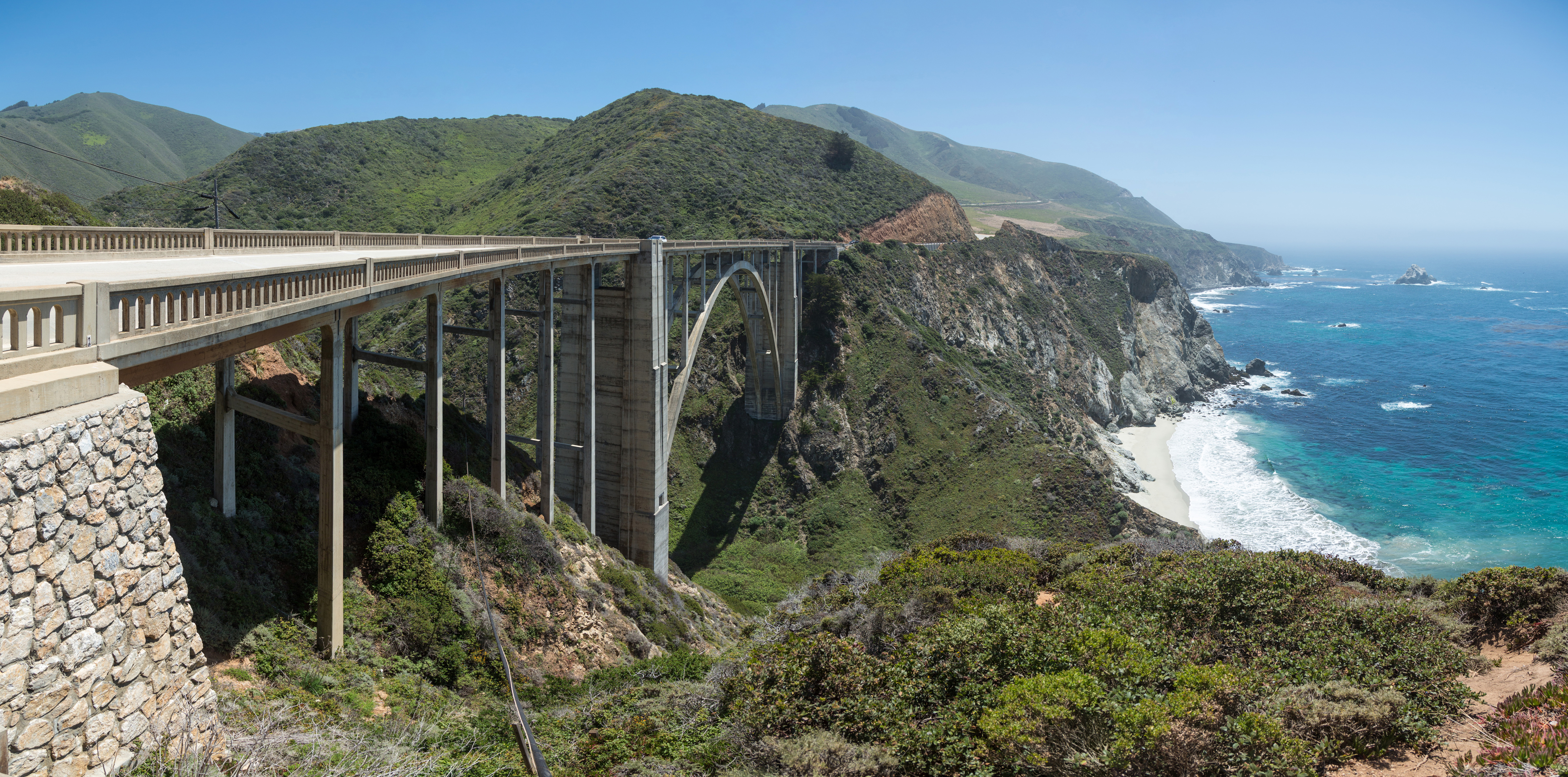
Bixby Bridge
The concrete blends so seamlessly with the coastal cliffs that you almost miss the bridge until you are crossing it. That was intentional. When California engineers designed Bixby Bridge in the early 1930s, they chose concrete specifically because it would echo the color and composition of the natural rock formations along the Big Sur coast. The result, completed in 1932, is an open-spandrel arch bridge that has become one of the most photographed structures on the West Coast, its graceful parabolic curve suspended above Bixby Creek Canyon where Highway 1 makes its dramatic journey along the Central California coastline.
Breaking Isolation
Before 1932, residents of Big Sur lived in genuine isolation. The Old Coast Road wound miles inland to circumvent the deep canyon, and every winter, blockages made it impassable. A trip from Carmel could take three days by wagon or stagecoach. Coast residents depended on an annual schooner from Monterey and San Francisco for supplies that could not be transported overland. The bridge changed everything. Built under budget for $199,861, the structure connected communities that had been cut off for months each year. At the ribbon-cutting ceremony, Dr. John L.D. Roberts, who had first conceived the need for the coastal highway, celebrated a new era of accessibility along one of America's most rugged coastlines.
Engineering Against the Elements
Building across a deep canyon exposed to Pacific storms required extraordinary measures. Workers transported over 300,000 board feet of Douglas fir timber from Monterey over narrow, one-way roads to construct the falsework that would support the arch during construction. The temporary scaffolding rose high above the creek bed, constantly battered by high winds. Some of the falsework timbers were massive. When high waves threatened the foundation, construction halted until winter storms abated. Crews transported 45,000 sacks of cement across the canyon on platforms using slings suspended from cables above the creek. The engineers designed the bridge to support more than six times its intended load, a margin of safety that has served the structure well for nearly a century.
Before the Bridge
Charles Bixby gave the creek its name. In the 1870s and 1880s, he ran a sawmill on the creek, then known as Mill Creek, harvesting timber and producing shakes, shingles, railroad ties, and fence posts. He also harvested tanbark oak bark for tanning cow hides and discovered lime deposits on Long Ridge above the canyon. Since building a wharf from the sheer cliffs was impossible, Bixby constructed a doghole port with a hoist and chute. Barrels of powdered lime were attached to cables strung from the coastal cliff, hoisted in slings about 50 yards out into the Pacific, and loaded onto coastal schooners moored to deadeyes embedded in the adjacent rocks. The landing operated until roads made such precarious methods unnecessary.
The Rainbow Lodge Era
In 1919, Army Captain Howard Sharpe and his wife Frida bought the Bixby Creek canyon property after timber harvesting was no longer profitable. They operated the Rainbow Lodge resort upstream from what would become the bridge site. When the bridge opened, their lodge was no longer on the tourist route, so in 1931 Sharpe built a new stone Rainbow Lodge on the highway shoulder immediately north of the bridge. In 1938, Sharpe made a discovery that changed conservation history: he found a colony of California sea otters, thought to be extinct. Tourists flocked to see the otters, and Sharpe added cabins and renamed his establishment the Bixby Inn. A fire in 1941 burned what remained of the original ranch on the canyon floor.
Preserved Against Development
The land surrounding Bixby Bridge faced repeated threats from development. In 1986, a logging company obtained permits to harvest over a million board feet of redwood north of the bridge, but the savings and loan crisis derailed the plan. The Big Sur Land Trust acquired the property for $1.2 million in 1987, made possible by a bridge loan from the David and Lucile Packard Foundation. South of the bridge, Allen Funt, creator of Candid Camera, owned the Brazil Ranch from 1977 until his death in 1999. After developers subdivided the property, the Trust for Public Land purchased it for $26.25 million in 2001. Today, both properties are protected: the northern land as part of Mill Creek Redwood Preserve, the southern land as part of Los Padres National Forest. In 1966, First Lady Lady Bird Johnson led the official scenic road designation ceremony at Bixby Bridge.
From the Air
Bixby Bridge spans Bixby Creek Canyon at coordinates 36.3714N, 121.9019W along the Big Sur coast. The bridge is best viewed from the south or west at altitudes between 1,000 and 3,000 feet AGL for the full perspective of the arch against the Pacific Ocean. The nearest airport is Monterey Regional (KMRY), approximately 25 nautical miles north. Morning flights often encounter coastal fog that can obscure the bridge; afternoon visibility is typically better. The Rocky Creek Bridge and Malpaso Creek Bridge, similar concrete arch structures, are visible a few miles to the north along Highway 1.