Black Eagle Dam
On June 14, 1805, Meriwether Lewis stood before a 26-foot cataract on the Missouri River and noticed something remarkable: on a cottonwood tree growing from a small island in the churning mist, an eagle had built her nest. "A more inaccessible spot I believe she could not have found," Lewis wrote, "for neither man nor beast dare pass those gulphs which separate her little domain from the shores." That black eagle gave the falls its name, and nearly a century later, the falls gave Montana its first taste of industrial power. The timber-and-rock dam that opened here in 1890 was the first hydroelectric dam built in Montana and the first on the Missouri River - a distinction that would transform Great Falls from a frontier settlement into the "Electric City."
Gibson's Gamble
Paris Gibson had a vision. The sheep rancher and Minneapolis flour mill operator saw the five waterfalls of the Missouri not as obstacles but as engines waiting to be harnessed. In 1887, with railroad magnate James J. Hill organizing investors from the Great Northern Railway, the Great Falls Water Power & Townsite Company was formed with five million dollars in capital. Gibson promoted his dreamed-of city on the promise of abundant, cheap electricity - but that promise required actually building dams. When the Boston and Montana mining company signed an agreement in September 1889 requiring delivery of power by the following year, the race began. GFWPTC engineers designed a rock-and-timber crib weir dam on the upstream brink of the falls. Workers who built it helped found the adjacent town of Black Eagle; earthen foundations from their shantytown remain visible today.
Ropes and Pulleys
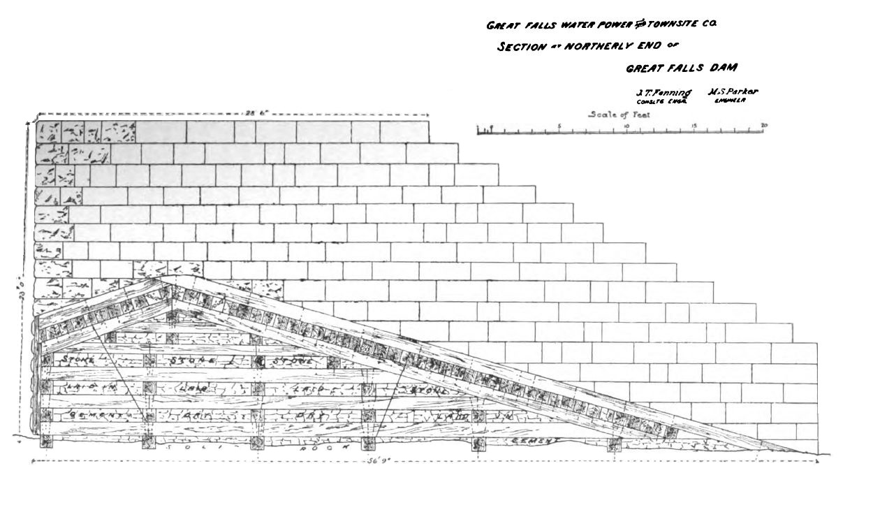
The 1890 dam represented an earlier age of power transmission. Water turned turbines in two powerhouses flanking the river, but the mechanical energy wasn't primarily converted to electricity. Instead, an elaborate system of ropes and pulleys transferred power directly to the Boston and Montana smelter's equipment. Thomson-Houston generators transformed only some of this mechanical energy into electrical current. By 1892, more than a thousand workers labored at the smelter complex, which grew to include concentrators, furnaces, converters, and an electrolytic refinery. The dam's engineers estimated a fifty-year lifespan for their timber structure - optimistic, perhaps, but not unreasonable given the technology of the era.
Concrete Replaces Timber
In 1926, the Montana Power Company announced a million-dollar reconstruction. The new concrete dam, completed in 1927, rose over the submerged remains of the original timber structure, which was never removed. The rebuilt dam featured an ogee-shaped crest for improved water flow and a powerhouse containing three Allis-Chalmers turbines capable of generating seven megawatts each. The original south forebay was abandoned while the north forebay underwent significant rehabilitation. Workers once walked across the dam's top to reach jobs and schools on the opposite bank - a practice the Montana Power Company ended during World War II for security reasons and never resumed.
The River Remembers
Floods have tested Black Eagle Dam repeatedly. In June 1975, more than five inches of rain fell in the Rocky Mountains within 24 hours, forcing the evacuation of 5,000 Great Falls residents when the Sun River rose 18 feet above flood stage. In 1997, rapid snowmelt pushed the Missouri itself 10 feet above flood level. Ice poses different dangers: in December 2010, floating blocks overwhelmed the dam's crest, tearing handrails from the maintenance walkway. The dam's license requires it to release water over the falls between 9 AM and 8 PM on summer weekends and holidays - meaning Black Eagle Falls sometimes runs dry when power generation takes priority. Maintenance drawdowns have repeatedly exposed the Missouri's original channel near Giant Springs.
Black Eagle Memorial Island
The island where Lewis spotted that eagle's nest has been transformed. In 2001, Tailrace Island was renamed Black Eagle Memorial Island to honor workers who lost their lives building and operating the dam. The River's Edge Trail, opened in 1991 along former Burlington Northern Railroad tracks, now connects the island to riverside parks and viewing areas. The annual Lewis and Clark Festival in late June and the mid-July Luminaria Walk draw visitors who watch the falls illuminated by colored spotlights. Westslope cutthroat trout, first identified here by Lewis and Clark themselves, still swim these waters. Above the dam, the only two red oak trees in northcentral Montana grow on the hillside - though beavers have proven such persistent threats to local vegetation that officials now protect trees throughout the city's riverside parks.
From the Air
Black Eagle Dam sits at coordinates 47.5197N, 111.2631W on the Missouri River within the city limits of Great Falls, Montana. The dam and its reservoir (Long Pool) are clearly visible from altitude as a linear structure crossing the river with distinct spillway patterns. The historic smelter smokestack on the adjacent industrial site provides an additional landmark. Great Falls International Airport (KGTF) lies approximately 5 nautical miles southwest. The dam is part of a series of five falls and dams on this stretch of the Missouri; Black Eagle is the easternmost. Best viewed at 1,500-3,000 feet AGL to appreciate the dam structure, the island, and the urban context of Great Falls surrounding the river corridor.