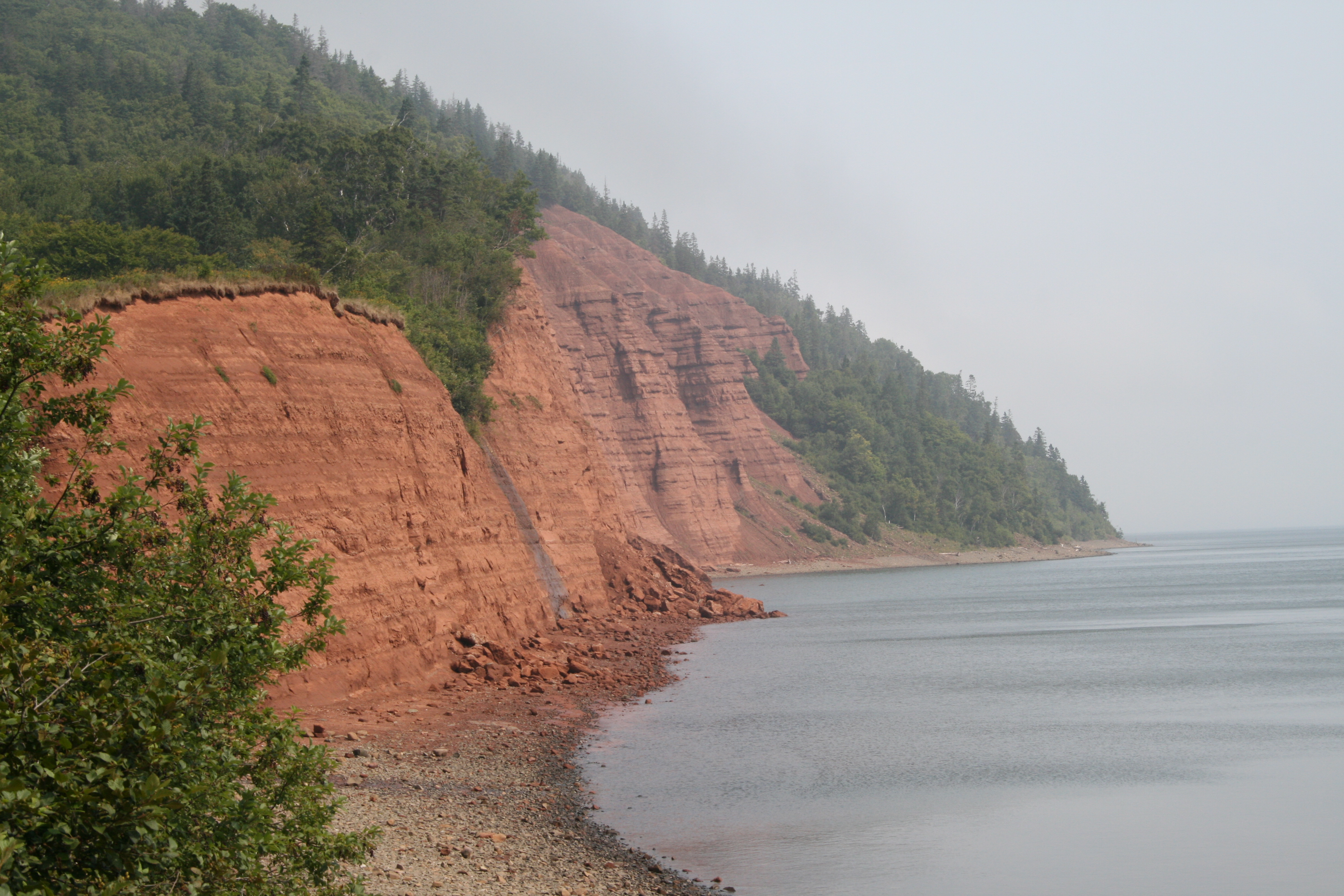
Blomidon Provincial Park
Twice a day, the ocean vanishes. Where waves crashed against the base of the cliffs just hours ago, a vast mudflat stretches toward the horizon, glistening and strange. Then the tide returns, filling the Minas Basin with roughly one hundred billion tonnes of seawater in a single cycle, a volume greater than the combined flow of all the world's freshwater rivers. Blomidon Provincial Park occupies 759 hectares of clifftop land on Nova Scotia's Bay of Fundy coast, and everything about the place is defined by this tidal rhythm. The cliffs themselves rise 180 metres above the basin, their red sandstone faces striped with layers of geological time. From the top, the view alternates between ocean and exposed seabed in a cycle that has been running for thousands of years and shows no sign of stopping.
Where Glooscap Made His Home
Cape Blomidon, the headland that anchors the park, holds a central place in Mi'kmaq cosmology. According to tradition, it is the home of Glooscap, the powerful culture hero who shaped the landscape and taught the Mi'kmaq how to live. One version of the legend credits Glooscap with creating the Bay of Fundy's extraordinary tides after his enemy, Beaver, built a dam that flooded the Annapolis Valley. Glooscap struck the dam with a bolt of lightning, shattering it and releasing the waters. In another telling, the tides began simply because Glooscap decided he wanted a bath. The red soil that washes into the basin with each tidal cycle is said to be the stain from that first great flood. Whether you come to the park for geology or legend, the land itself is the same: ancient basalt from the North Mountain range meeting soft sandstone that the tides are slowly carving away.
The Fourteen-Kilometre Loop
The park's trail system links eight paths into a fourteen-kilometre loop that traverses forest, clifftop, and ravine. An interpretive trail introduces the geology and ecology of the area, while lookout points along the cliff edge offer views across the Minas Basin that change character with every shift of the tide. A waterfall drops through one of the ravines, fed by streams that cut through the red earth on their way to the basin below. The campground offers a hundred sites split between open field and sheltered woodland, and the beach at the base of the cliffs, accessible at low tide, is a destination in its own right. Beachcombers find agates, amethysts, and zeolites tumbled from the basalt cliffs by centuries of wave action, gems that Mi'kmaq legend says Glooscap scattered across the region.
The Name That Stuck
The cape has had many names. Samuel de Champlain, exploring the Bay of Fundy in the early seventeenth century, called it Cap Poutrincourt. Local Acadian settlers knew it as Cap Baptiste. English-speaking arrivals tried Cape Porcupine. But the name that endured was Cape Blowmedown, a blunt description of the winds that rake the headland, which over time softened into Blomidon. The name was officially approved on October 1, 1959, though by then it had been in common use for generations. Poet Charles G. D. Roberts immortalized the cape in verse, and the landscape has drawn painters and writers ever since. The park sits twenty kilometres north of Wolfville, the university town at the heart of the Annapolis Valley, and roughly a hundred kilometres west of Halifax.
Living on the Edge
The cliffs at Blomidon are actively eroding. The soft sandstone and the relentless tides conspire to undermine the headland, and chunks of cliff face calve into the basin with unpredictable regularity. What appears to be a trail near the edge may actually be a line of erosion leading to a steep drop with loose footing. The park is open from mid-May to October, and the nearby Grand-Pre National Historic Site and Fort Edward National Historic Site add historical depth to a visit. But the essential draw remains the tides. Standing on the clifftop as the basin empties, watching the water pull back to reveal a landscape that was invisible an hour before, you understand why the Mi'kmaq placed their most powerful stories here. Some forces are too large to explain without myth.
From the Air
Located at 45.27N, 64.34W on the north shore of the Minas Basin in Nova Scotia. The park's 180-metre red sandstone cliffs are a striking visual landmark from the air, especially at low tide when the vast exposed mudflats of the Minas Basin create a dramatic contrast. Nearest airports are Halifax Stanfield International (CYHZ), approximately 100 km east, and Greenwood (CYPD) in the Annapolis Valley to the west. Best viewed at 2,000-4,000 feet to appreciate the cliff formations and tidal patterns.