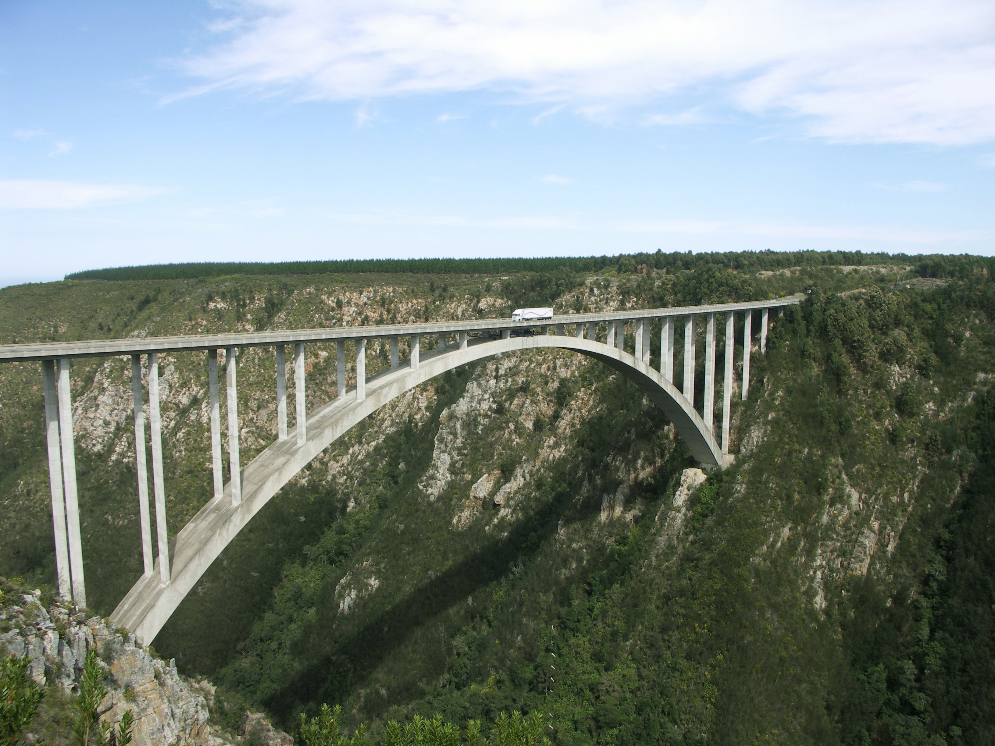
Bloukrans Bridge
For most of the 30,000 vehicles that cross it each month, the Bloukrans Bridge is a few seconds of elevated highway, a flash of gorge, and then gone. For the people who stop, clip in, and step off the catwalk beneath the road deck, it is the longest 7 seconds of their lives. At 216 meters above the Bloukrans River, this concrete arch carries both the N2 national highway and the world's highest commercial bridge bungee operation -- a combination of infrastructure and adrenaline that has made it one of the most recognizable structures on South Africa's Garden Route.
Engineering Above the Gorge
The bridge was designed by the South African firm Liebenberg and Stander (known as Bergstan SA) and built by Concor between February 1980 and June 1983. Its central arch spans 272 meters, and the entire structure stretches 451 meters from abutment to abutment. The design is a deck arch -- the roadway sits above the arch, supported by vertical columns that transmit the load down into the curved concrete span beneath. Construction in this location presented its own challenges: the Bloukrans River gorge is steep-sided and densely forested, with the Tsitsikamma Mountains rising behind. The bridge carries the N2, the main coastal highway connecting Cape Town to Port Elizabeth, making it a critical piece of national infrastructure as well as a tourist attraction.
The Highest Jump
Since 1997, Face Adrenalin has operated the Bloukrans Bridge Bungy from a platform accessible via a catwalk beneath the road deck. The jump itself covers 216 meters of free fall before the bungee cord catches, making it the highest commercial bridge bungee in the world. Jumpers walk along a metal catwalk suspended under the arch, the river visible through the grating beneath their feet, before reaching the jump platform at the center of the bridge. The experience takes only a few seconds of actual falling time, but the walk out -- with traffic rumbling overhead and the gorge yawning below -- is its own form of controlled terror. The operation draws tens of thousands of jumpers annually, from first-time thrill-seekers to repeat visitors who collect jumps the way others collect stamps.
A Border in the Air
The Bloukrans River flowing beneath the bridge serves as more than scenic backdrop. It marks the boundary between the Western Cape and Eastern Cape provinces, making the bridge one of the few structures in South Africa that literally spans a provincial border. The gorge sits within the Tsitsikamma region of the Garden Route, surrounded by indigenous forest and fynbos. From the bridge, the views extend down the river valley to the Indian Ocean, where the coastline wraps eastward toward Storms River Mouth and the start of the Otter Trail. The bridge sits roughly 20 kilometers east of Nature's Valley and 40 kilometers west of Storms River, positioning it at the heart of the Tsitsikamma's adventure tourism corridor.
More Than a Leap
What makes the Bloukrans Bridge compelling is the collision of the ordinary and the extraordinary. The N2 is a working highway, carrying trucks, tour buses, and commuters along the coast. The bridge is a piece of functional engineering, built to move traffic efficiently across a gorge that would otherwise require a long descent and climb. Yet beneath that same road surface, people voluntarily step into empty space for the pure sensation of falling. The surrounding landscape adds to the contrast: this is Tsitsikamma country, where ancient yellowwood forests grow at a pace measured in centuries, where the Otter Trail demands five days of patient walking, and where the forest edge advances by meters over lifetimes. Against all that slow accumulation, the bungee jump offers something instantaneous -- seven seconds of gravity, a rush of blood, and a view of the river that no one who has experienced it forgets.
From the Air
Coordinates: 33.97S, 23.65E. The Bloukrans Bridge is a distinctive arch bridge crossing a deep gorge along the N2 highway in the Tsitsikamma region. The concrete arch is clearly visible from the air, especially at altitudes of 2,000-5,000 ft. The gorge and river below provide strong visual contrast. Nearest airports: George (FAGE), approximately 120 km west; Port Elizabeth (FAPE), approximately 180 km east. The N2 highway corridor and surrounding forest make orientation straightforward.