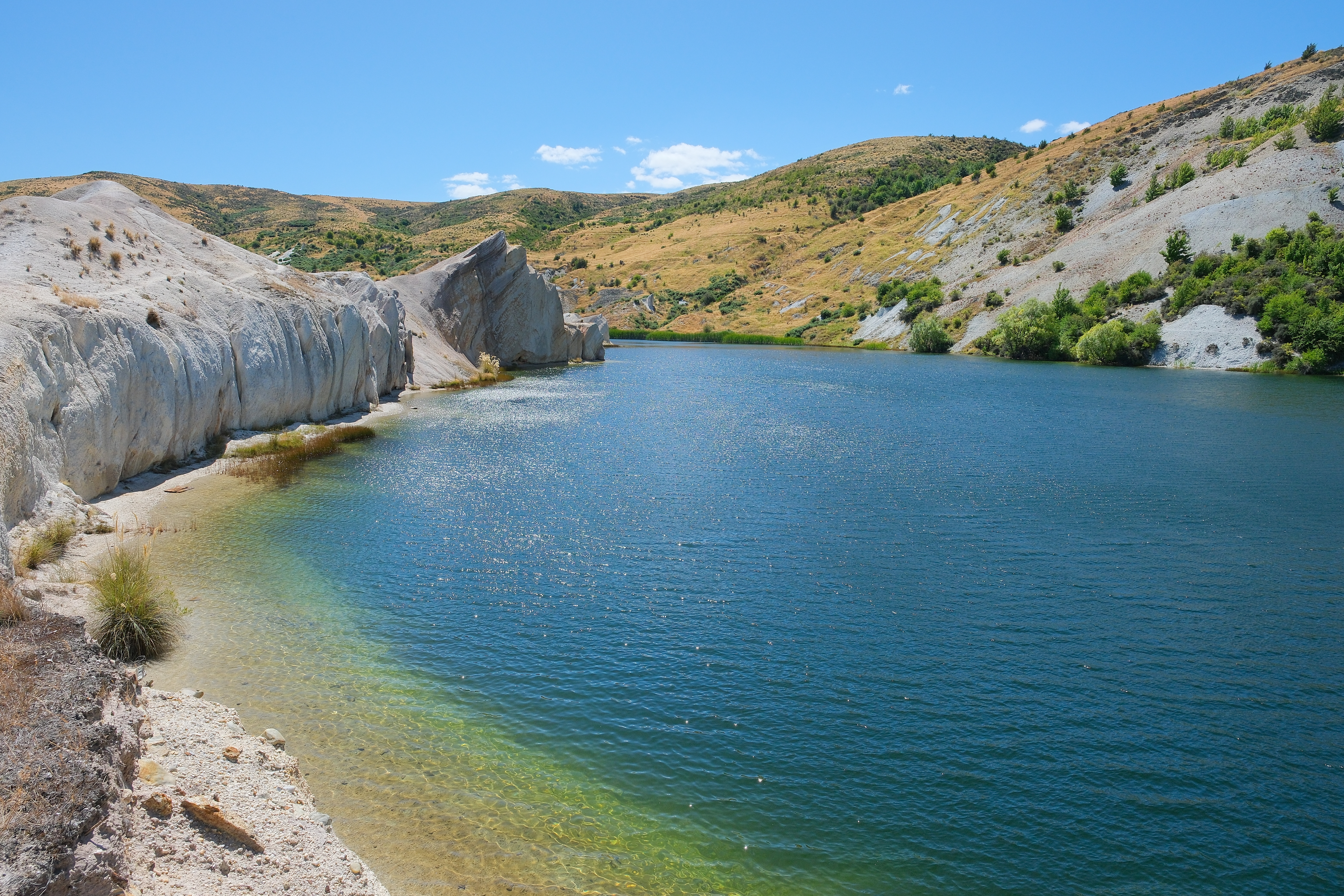
Blue Lake (Otago)
There used to be a hill here. Kildare Hill rose 120 metres above the Central Otago plateau near Saint Bathans, an unremarkable bump in a landscape of tawny tussock and schist outcrops. Then, in 1873, a man named John Ewing pointed high-pressure water cannons at it and started washing it away. Sixty years later, the hill was gone. In its place sat a hole 68 metres deep - the deepest hydraulic mining excavation in the world at the time. When the miners finally walked away in 1932, groundwater and rain did what water does: filled the void. The result is Blue Lake, a startlingly vivid turquoise pool that looks like it belongs in a tropical postcard, not in the dry, golden hills of inland Otago. It is a lake that exists because someone removed a mountain, and it is beautiful in the way that only accidental things can be.
The Man Who Ate a Hill
John Ewing was not a patient prospector with a pan and a dream. He was an industrialist. Born in 1844, he formed the St. Bathans Channel Company and introduced hydraulic elevating to the Kildare Hill Gold Claim - a technique that used pressurized water to blast gold-bearing gravel from hillsides and sluice it through channels where the heavy metal settled out. The scale was unprecedented in New Zealand. His company constructed a tailings channel to carry away the waste rock and pushed the excavation deeper year after year. The operation became the deepest hydraulic elevating site in the world, chewing through Kildare Hill from the top down, turning solid earth into slurry and slurry into profit. It worked until 1902, when a simple problem of physics intervened: the hole had grown so deep that the tailings channel no longer had enough fall to carry the waste material away. The water couldn't climb out of the pit it had dug.
Bankruptcy and the Second Company
Ewing's story did not end well. By 1905 he was bankrupt, undone not by the Kildare Hill claim itself but by poor investments elsewhere. The claim passed to the Scandinavian Water Race Company, which restarted operations with fresh capital and a new approach to the tailings problem. For another 27 years they worked the site, extracting gold from the ever-deepening crater where Kildare Hill had stood. The work finally stopped in 1932, and the reason was more interesting than exhaustion of the gold: engineers feared that further digging would undermine the foundations of nearby Saint Bathans itself. The town that had grown up to serve the mine was now threatened by it. The miners walked away, leaving behind a void shaped like an inverted mountain - a negative space where a positive one had been.
The Accidental Jewel
What happened next required no human effort at all. Rainfall and natural drainage from the surrounding hills slowly filled the abandoned pit with water. The resulting lake took on a vivid blue-green color - a product of the minerals in the exposed rock and the clarity of the groundwater-fed pool. The name "Blue Lake" is descriptive rather than imaginative, but the color itself defies adequate description. Depending on the light and season, the water shifts from deep sapphire to pale turquoise to an almost electric azure that looks artificially enhanced in photographs but isn't. The lake has no inlet stream and no outlet. It simply sits in its hole, reflecting the Central Otago sky, ringed by the raw earth walls that hydraulic mining carved. Today, visitors swim in it, fish in it, kayak across it, and bodyboard in its surprisingly clear water. Saint Bathans, the tiny settlement that nearly lost its foundations to the mine, has gained an unlikely tourist attraction - a swimming hole made of absence, beautiful because of what was taken away.
From the Air
Located at 44.87°S, 169.81°E near the hamlet of Saint Bathans in the Maniototo district of Central Otago. The lake is a distinctive blue-green water feature visible from altitude, sitting in an excavated pit surrounded by bare earth walls - easily identifiable against the surrounding tussock grassland. The nearest airfield is Alexandra Airport (NZLX), approximately 45 km to the south. Queenstown Airport (NZQN) is about 120 km to the west. The Lindis Pass highway (SH8) runs to the west, connecting Wanaka to the Mackenzie Country. From cruising altitude, the lake's vivid color contrasts sharply with the dry, golden terrain of the Maniototo. Elevation approximately 600 m. Central Otago has a continental climate with extreme temperature ranges; clear skies are common, especially in winter.