Blue Ledge Mine
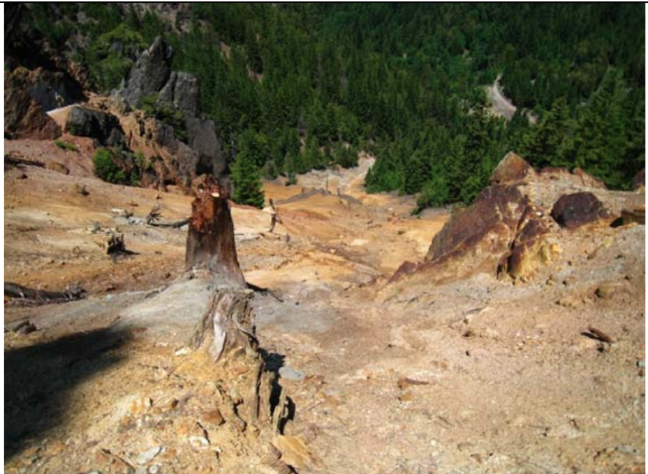
No fish swim in Joe Creek. The stream runs through the Siskiyou Mountains with water so contaminated by cadmium, copper, lead, arsenic, and zinc that nothing can survive in it. The source of this poison sits at 4,800 feet elevation, three miles south of the California-Oregon border: the Blue Ledge Mine, one of the largest mining operations in the region's history, now a Superfund site where more than 70,000 tons of toxic waste rock once lay scattered across steep hillsides and narrow drainage channels.
Gold Seekers Find Copper
Three miners panning for gold in Joe Creek discovered the Blue Ledge deposit in 1898. They had come looking for placer gold but found something the new century would hunger for: copper. Mining operations began in 1905, ramping up dramatically as World War I drove demand for the metal used in shell casings, electrical wire, and machinery of war. Between 1917 and 1920, the mine produced 9,000 tons of high-grade sulfide ore. Workers hand-sorted the ore at the mine site, then loaded it onto a tram that carried it down the mountain. From there, wagons hauled the copper ore to the Rogue Valley, where it was shipped to Tacoma, Washington for smelting.
Brief Boom, Long Silence
The mine fell quiet after 1920, a victim of peacetime economics. For nearly a decade, the tunnels stood empty and the tramway rusted. Then in 1930, operations briefly resumed, extracting another 2,600 tons of ore before shutting down permanently. The underground excavations stretched more than two miles, a labyrinth of passages carved into the mountain's sulfide-rich rock. When the miners left, they abandoned their waste rock in four discrete piles on the steep slopes, the deepest pile reaching 30 feet thick. No one considered then what rain and time would do to those heaps of pulverized stone.
Acid Bleeds from Stone
Sulfide deposits react with air and water in a process called acid mine drainage. Weathering oxidizes sulfur minerals to sulfate and acid, a reaction accelerated by naturally occurring microbes that feast on reduced minerals. The resulting sulfuric acid leaches metals from waste rock into groundwater and streams. At Blue Ledge, the waste was particularly dangerous because it consisted of fine particles with enormous surface area, maximizing the rate of metal release. The mine had operated with a waste-to-ore ratio of 6:1, leaving behind a chemical time bomb that would poison Joe Creek for generations.
Superfund Intervention
In 2006, the Environmental Protection Agency authorized $484,302 for emergency response at Blue Ledge, classifying it as a Superfund site requiring Time-Critical Removal Action. Workers relocated waste rock from drainage channels, constructed an open limestone channel to neutralize acid, and built log dams to retain debris. These short-term fixes bought time for a permanent solution. The long-term plan called for something more ambitious: consolidating all four waste piles into a single underground repository, essentially reburying the mine's toxic legacy.
Entombed in Plastic
Engineering/Remediation Resources Group completed the permanent repository in 2010. Workers excavated a containment area below the mine surface and lined it with high-density polyethylene, then covered that liner with gravel for drainage and a clean soil cushion to prevent punctures. They moved all 70,000-plus tons of waste rock into this engineered tomb, then sealed it with additional soil, gravel, a linear low-density polyethylene cover, and three feet of cover soil. The site was reclaimed as wildlife habitat, roads were reconditioned, and the mountain began to heal. Whether fish will ever return to Joe Creek remains an open question, one that may take decades to answer.
From the Air
Blue Ledge Mine sits at 41.96N, 123.11W in the Siskiyou Mountains, approximately 3nm south of the California-Oregon border within the Rogue River-Siskiyou National Forest. The site occupies a ridge near 4,800 feet elevation. From the air, look for cleared areas and access roads on the forested mountainside; the remediated waste repository lies below surface and is not directly visible. Joe Creek drainage runs north toward Oregon. Nearest airports include Happy Camp (36S) approximately 20nm south and Grants Pass (3S8) about 35nm north. Exercise caution in this mountainous terrain with ridges exceeding 5,000 feet.