Bodie Island Lighthouse
Locals will correct you on the pronunciation: it is "body," not "boh-dee." The name has nothing to do with drowned sailors, despite the grim reputation of this coastline as the Graveyard of the Atlantic. Bodie Island takes its name from the Body family, who once owned the land when it was still a true island, separated from the Currituck Banks by Roanoke Inlet until that passage closed in 1811. The distinction matters here, because this lighthouse has always been tangled up in stories people tell about it that turn out to be slightly wrong -- and the real history is more interesting than the folklore.
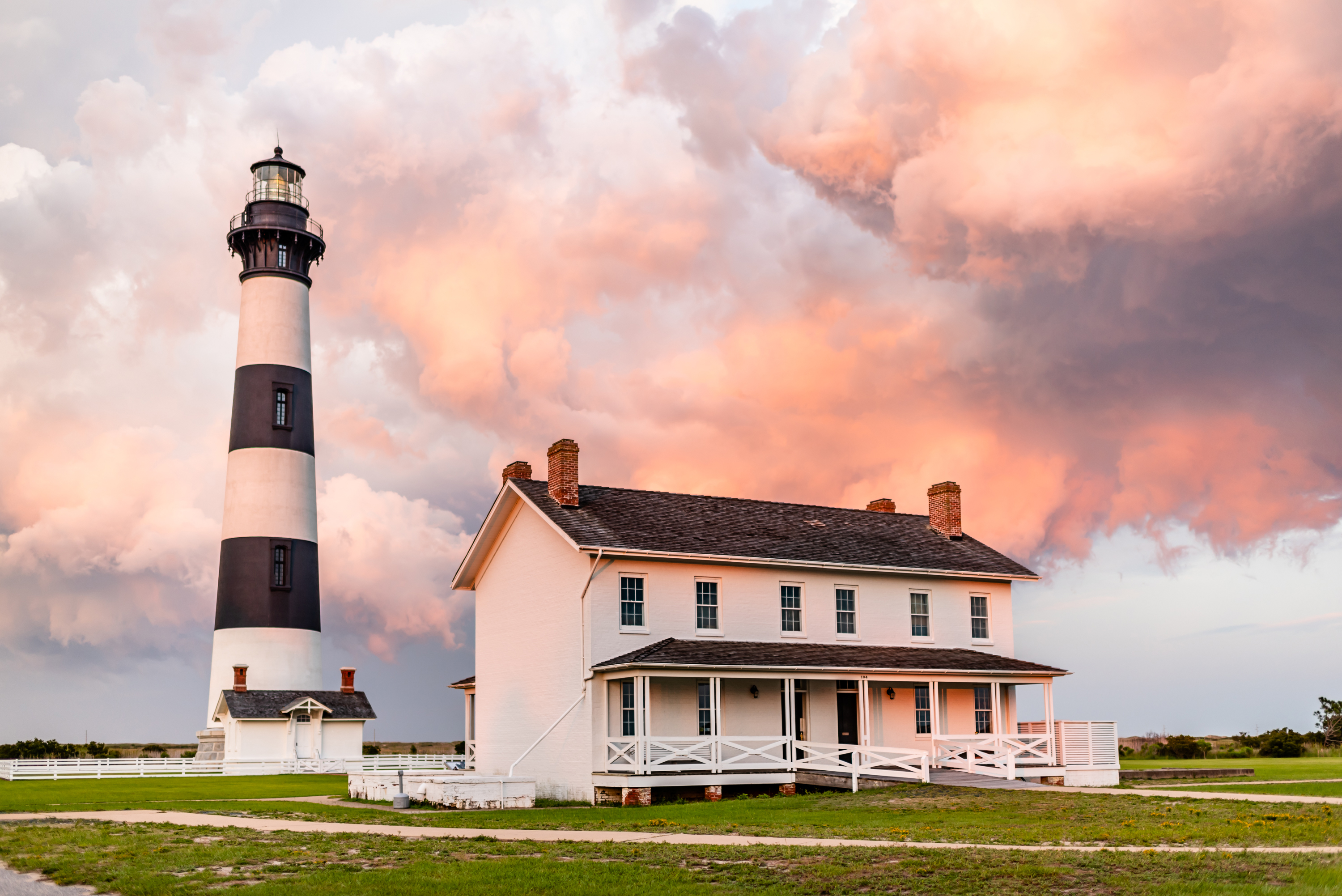
Third Time Standing
The first Bodie Island Lighthouse went up in 1847, south of Oregon Inlet on Pea Island. It lasted twelve years before its poor foundation forced abandonment. The second, built in 1859, stood for just two years before retreating Confederate troops destroyed it in 1861, fearing the Union Army would use it as an observation post during the Civil War. The third attempt, completed in 1872, was placed further north and further inland on a 15-acre site. This time, the builders got it right. The 156-foot tower of brick and iron has stood for over 150 years, its horizontal black-and-white bands unmistakable against the flat coastal landscape. It still holds its original first-order Fresnel lens, one of only a handful of such lenses still in operation at American lighthouses.
The Graveyard at Its Feet
The waters off Bodie Island have claimed ships for centuries. Storms, shallow shoals, and shifting sandbars made navigation treacherous long before anyone built a light here. During both World Wars, German U-boats added to the toll, hunting Allied merchant ships silhouetted against the shore lights. Local gift shops still sell maps of the wrecks scattered across the ocean floor, a cottage industry built on catastrophe. The lighthouse itself became a minor celebrity in 1963 when it appeared in the background of the Federal Duck Stamp, an unlikely intersection of maritime history and waterfowl conservation that speaks to the strange, layered character of the Outer Banks.
Automation and Abandonment
For sixty years, keepers climbed the 219 steps to tend the light. In 1932, the Bodie Island Lighthouse was automated, its flame replaced by an electric lamp powered by oil-fueled generators. The keepers stayed on until 1940, when full automation made them redundant. By 1953, the National Park Service had taken custody and the generators gave way to the commercial power grid. The keeper's quarters stood empty, and the tower itself was closed to the public -- an artifact more than a working aid to navigation, though the light still turned every night.
A Long Restoration
The effort to restore the lighthouse took years of fundraising and suffered repeated setbacks. Scaffolding went up in August 2009. By March 2010, the exterior work was complete, but in spring 2011 inspectors discovered serious structural problems in the support beams beneath the balcony, and work stopped. Then Hurricane Irene arrived in August 2011, blowing out newly restored lantern room glass and tearing away the protective shroud. Flooding buckled the floors in the Double Keepers Quarters. Additional funding was secured, work restarted in 2012, and the restoration was finally completed in March 2013. On April 18, 2013, the light was ceremonially relit, and the next day the public was allowed to climb the tower for the first time, ascending 219 iron steps to a view that stretches from Roanoke Sound to the open Atlantic.
From the Air
Located at 35.82N, 75.56W on the Roanoke Sound side of the Outer Banks, just south of Nags Head and a few miles north of Oregon Inlet. The black-and-white horizontal banding on the 156-foot tower is distinctive from the air. Nearest airports include Dare County Regional Airport (KMQI) near Manteo and First Flight Airport (KFFA) at Kill Devil Hills. Fly at 1,000-2,000 feet along the barrier island chain for the best perspective on the lighthouse, the keeper's quarters, and the marshland surrounding it.