Bogibeel Bridge
Four prime ministers laid claim to it before a single vehicle crossed. The foundation stone was placed by H. D. Deve Gowda in January 1997. The construction was inaugurated by A. B. Vajpayee in 2002. National project status was granted under Manmohan Singh in 2007. And on December 25, 2018, Narendra Modi finally cut the ribbon on the Bogibeel Bridge, a 4.94-kilometer double-decker crossing over the Brahmaputra River in upper Assam. The date was chosen to coincide with Vajpayee's birth anniversary and Good Governance Day, a title that must have carried a certain irony for the five million people who had waited two decades for the bridge to connect their lives.
A Promise Born from Accord
The Bogibeel Bridge traces its origins to the Assam Accord of 1985, a political agreement that ended a six-year anti-immigration movement in Assam and promised major infrastructure development for the state's neglected northeast. Among the commitments was a bridge over the Brahmaputra to connect Dhemaji district on the north bank with Dibrugarh district on the south. The government sanctioned the project in 1997-98, expecting completion within the Ninth Five Year Plan. That optimism proved spectacularly premature. Though the foundation was laid in January 1997, actual construction did not begin until 2002, and even then the work stalled almost immediately. By 2007, not a single pier had risen from the riverbed, and the government was forced to designate Bogibeel a national project to unlock dedicated funding.
Sixteen Years in the Making
Construction consumed 200 months from its 2002 start to the December 2018 opening. The delays had compounding causes: insufficient funding, bureaucratic inertia, the logistical nightmare of building in a floodplain that becomes an inland sea during monsoon season. The Northeast Frontier Railway contracted Gammon India for the substructure in 2008, while a consortium led by Hindustan Construction Company, the German firm DSD Bruckenbau GmbH, and VNR Infrastructures took on the superstructure. The Union Ministry of Finance covered 75% of costs, with the Ministry of Railways financing the remainder. None of this prevented the budget from spiraling. The original estimate escalated dramatically by 2014, and the final cost climbed further as the bridge's total length grew from the planned 4.31 kilometers to 4.94 kilometers. The bridge became a case study in how India's infrastructure ambitions collide with its implementation challenges.
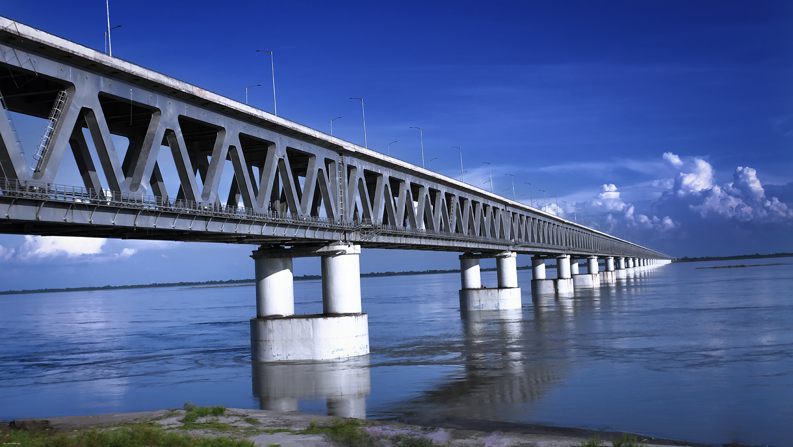
Steel and Strategy Over the Brahmaputra
The finished bridge is an engineering achievement regardless of how long it took. Forty-one spans of 125 meters each carry a superstructure of composite welded steel truss and reinforced concrete in a double-decker configuration: three lanes of road highway on the upper deck and a double broad-gauge rail line below. It is India's longest combined rail-and-road bridge. But the design serves more than civilian traffic. The bridge was built to support the movement of military tanks and aircraft, reflecting its strategic importance in a region where India's border with Tibet runs through Arunachal Pradesh, just 20 kilometers to the north. Before Bogibeel, the nearest Brahmaputra crossing was the Kolia Bhomora Setu at Tezpur, 270 kilometers to the west, leaving upper Assam and Arunachal Pradesh connected to the rest of India by a single, distant link.
Connecting Five Million Lives
The first freight train crossed Bogibeel on December 2, 2018, three weeks before the official inauguration. Modi flagged off the Tinsukia-Naharlagun intercity express during the opening ceremony, establishing a direct rail link between upper Assam and the Arunachal Pradesh capital region. The bridge joins the Rangiya-Murkongselek railway section on the north bank to the Lumding-Dibrugarh section on the south, stitching together a rail network that had been split by the river for as long as it existed. For the nearly five million residents of upper Assam and Arunachal Pradesh, Bogibeel collapsed distances that had shaped daily life for generations. A journey that required a ferry crossing or a 270-kilometer detour through Tezpur now takes minutes. The bridge has a designed lifespan of 120 years. Whether it will be remembered more for its engineering or for the decades its absence cost the region remains an open question.
From the Air
Located at 27.41°N, 94.76°E over the Brahmaputra River in upper Assam, northeast India. The bridge is 4.94 km long and clearly visible from the air as a linear structure crossing the wide Brahmaputra floodplain between Dhemaji (north bank) and Dibrugarh (south bank). Nearest airports are Dibrugarh (VEMN) on the south bank and Lilabari (VELR) to the west. The Brahmaputra here is several kilometers wide during monsoon season. The double-decker steel truss structure is distinctive from moderate altitude. The Assam-Arunachal Pradesh border lies approximately 20 km to the north.