Bolan Pass
A British artillery officer described it in 1841: the road was a mountain torrent's bed, loose shingly gravel that receded underfoot, hemmed by rocky chasms a hundred feet high from which robbers hurled stones at travelers below. Flash floods came without warning -- "an almost perpendicular volume" of water that swept away men, horses, and camels in an instant. Thirty-seven people drowned in one such surge that the officer witnessed. This was the Bolan Pass, and for anyone trying to move between the Indian subcontinent and the highlands of Central Asia, it was one of the only ways through.
Where Continents Collide
The Bolan Pass cuts through the Toba Kakar range south of the Hindu Kush, connecting the city of Quetta on the highland plateau with Sibi on the Indus plains below. Geologically, it marks something profound: the southern boundary between the Indian Plate and the Iranian Plateau, a seam where subcontinental crust grinds against the ancient landmass of Central Asia. The pass's southern entrance near Dhadar sits at the western edge of the Indus Valley -- a crossroads with strategic sight lines toward Pakistan, Afghanistan, Iran, and the Arabian Sea. South of the pass, Brahui tribes extend their territory all the way to Cape Monze on the coast. To the north live Pashtuns; to the west, Baloch. Every power that sought to control the traffic between these worlds had to reckon with the Bolan.
The Southern Gate of Invasion
If the Khyber Pass is the famous front door to the subcontinent, the Bolan is the side entrance -- less celebrated but equally consequential. In 1748, the Afghan king Ahmad Shah Durrani used it to invade India, exploiting its proximity to his capital at Kandahar for faster access to the plains. When the British grew anxious about Russian ambitions in Central Asia, the Bolan became a strategic obsession. In February 1839, during the First Anglo-Afghan War, Sir John Keane marched 12,000 soldiers through the pass and into Kandahar, which the Afghan princes had already abandoned. The route they took was not the modern one but a rougher track further west at Siri Bolan, where limestone walls close in so tightly that three riders can barely pass abreast. In 1883, Sir Robert Groves Sandeman negotiated British control of the pass with the Khan of Kalat, Khudadad Khan, securing it in exchange for an annual fee -- the geography too valuable to leave in anyone else's hands.
Steel Through the Gorge
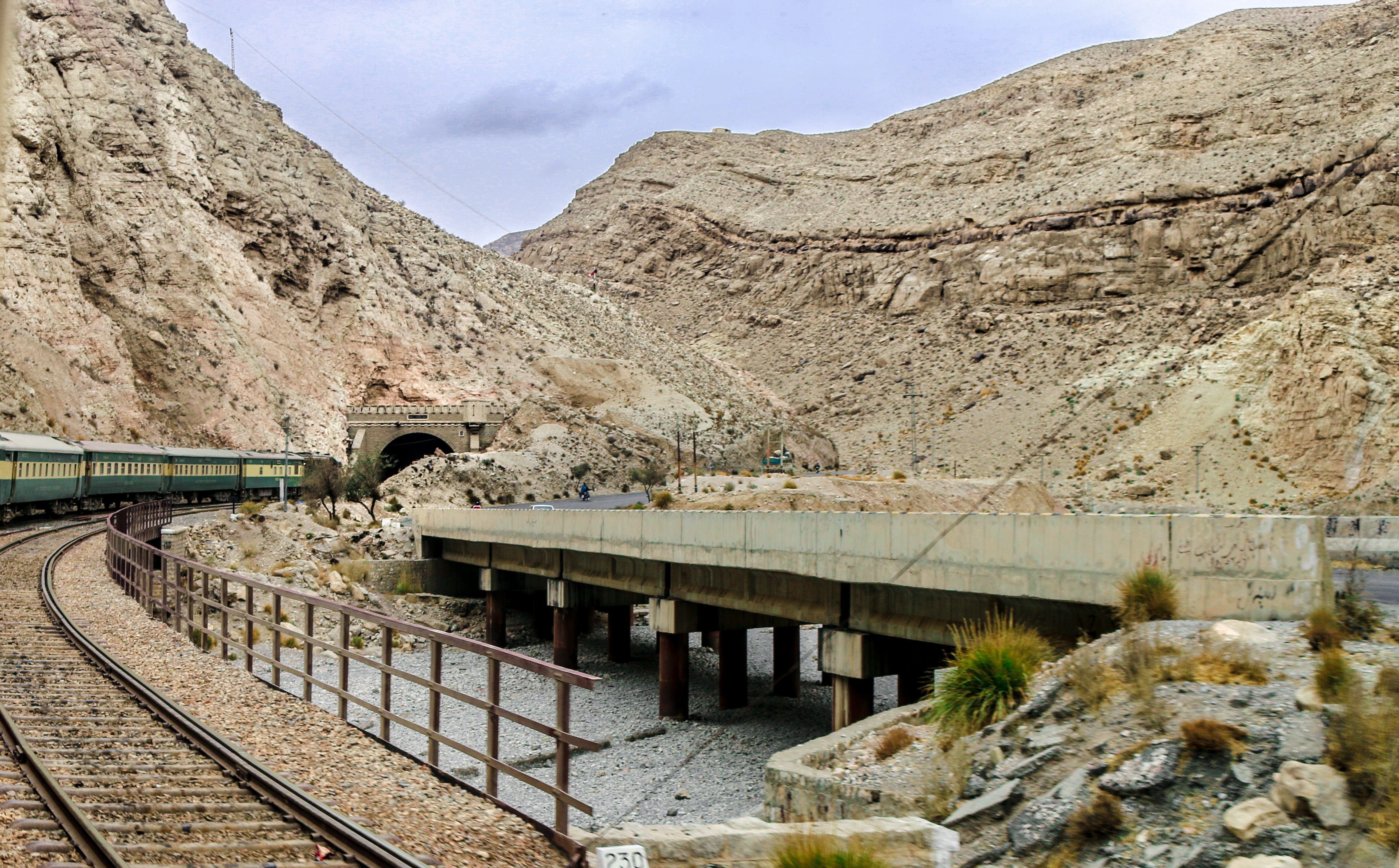
Building a railway through the Bolan was an act of engineering stubbornness. The original line from Sibi followed the Bolan stream to the plateau, but floods kept destroying it. Engineers rerouted through the Mashkaf valley, carrying the track from near the Mashkaf's head to a junction with the Bolan at Machh. An alternative route through the Harnai valley -- longer, starting in the opposite direction -- was tried for regular traffic, with the Bolan loop reserved for emergencies. But the Harnai line suffered its own floods and landslips. By 1895, the Bolan route was upgraded to carry all traffic. In 1942, catastrophic floods destroyed a large section, halting through service entirely. By the following year, bridges and track between Khost and Bostan had been recovered, but the line from Sibi to Khost remains out of service today. At the Khundilani gorge, conglomerate cliffs rise 800 feet on either side, enclosing the valley in a stone corridor where summer temperatures are brutal and winter winds funnel through with life-threatening force.
A Pass That Refuses Quiet
The Bolan has never been a place that permits safe passage without negotiation -- with the terrain, with the weather, with whoever controls the heights. Since 1877, when the Quetta agency was established, the British secured the pass using militias drawn from Baloch tribesmen, chiefly Marris. That arrangement held for decades but did not eliminate the underlying tension between those who built the road and those who lived above it. The pass remains contested ground. In 2025, the Jaffar Express passenger train was hijacked by the Balochistan Liberation Army within the Bolan, a reminder that the geography that made the pass strategically vital in the age of cavalry and cannon still shapes conflict in the age of rail. Empires change. The narrow defile between the mountains does not.
From the Air
Coordinates: 29.45N, 67.49E. The pass connects Quetta (elevation ~5,500 feet) with Sibi on the Indus plains, cutting through the Toba Kakar range. Dramatic terrain with gorges up to 800 feet deep -- the Khundilani gorge and Siri Bolan narrows are visible from above. Nearest major airfield: Quetta International Airport (OPQT) to the north. Extreme temperatures: dangerously hot in summer, ice-cold funneling winds in winter. Turbulence common in the confined valleys. Best viewed from 12,000-15,000 feet AGL to see the full length of the pass and the railway threading through it.