Bonaire
The license plates give it away. On Bonaire, every vehicle carries the slogan "Diver's Paradise" -- not as tourism branding but as a statement of civic identity, the way other places might display a state bird or motto. This small island in the Leeward Antilles, 80 kilometers off the Venezuelan coast, has built its entire modern existence around the reef that rings its shore. Ninety-seven dive sites encircle the island, many of them accessible by simply walking into the water from the road. The reef starts at the tideline and drops away, following the underwater contours of an island that is, at its geological core, nothing more than ancient coral pushed above the surface by the collision of two tectonic plates some 90 million years ago.
Islands of the Giants
The Caquetio people, a branch of the Arawak, arrived on Bonaire from South America around 500 AD, though archaeological evidence places the earliest human habitation on the island at approximately 1450 BC. The Caquetio left their mark in rock paintings and petroglyphs preserved in caves at Spelonk, Onima, Ceru Pungi, and Ceru Crita-Cabai. They also left an impression on the Spanish, who encountered them and -- struck by their height -- named the ABC islands las Islas de los Gigantes, "the islands of the giants." The name Bonaire itself likely derives from the Caquetio word Bonay, meaning "low country," though a competing theory traces it to the Spanish buen aire, "good air." Spain colonized the island beginning in 1499. The Spanish settled in Rincon, an inland town whose geography protected it from pirate raids, and used the island primarily for cattle ranching, raising livestock for hides rather than meat.
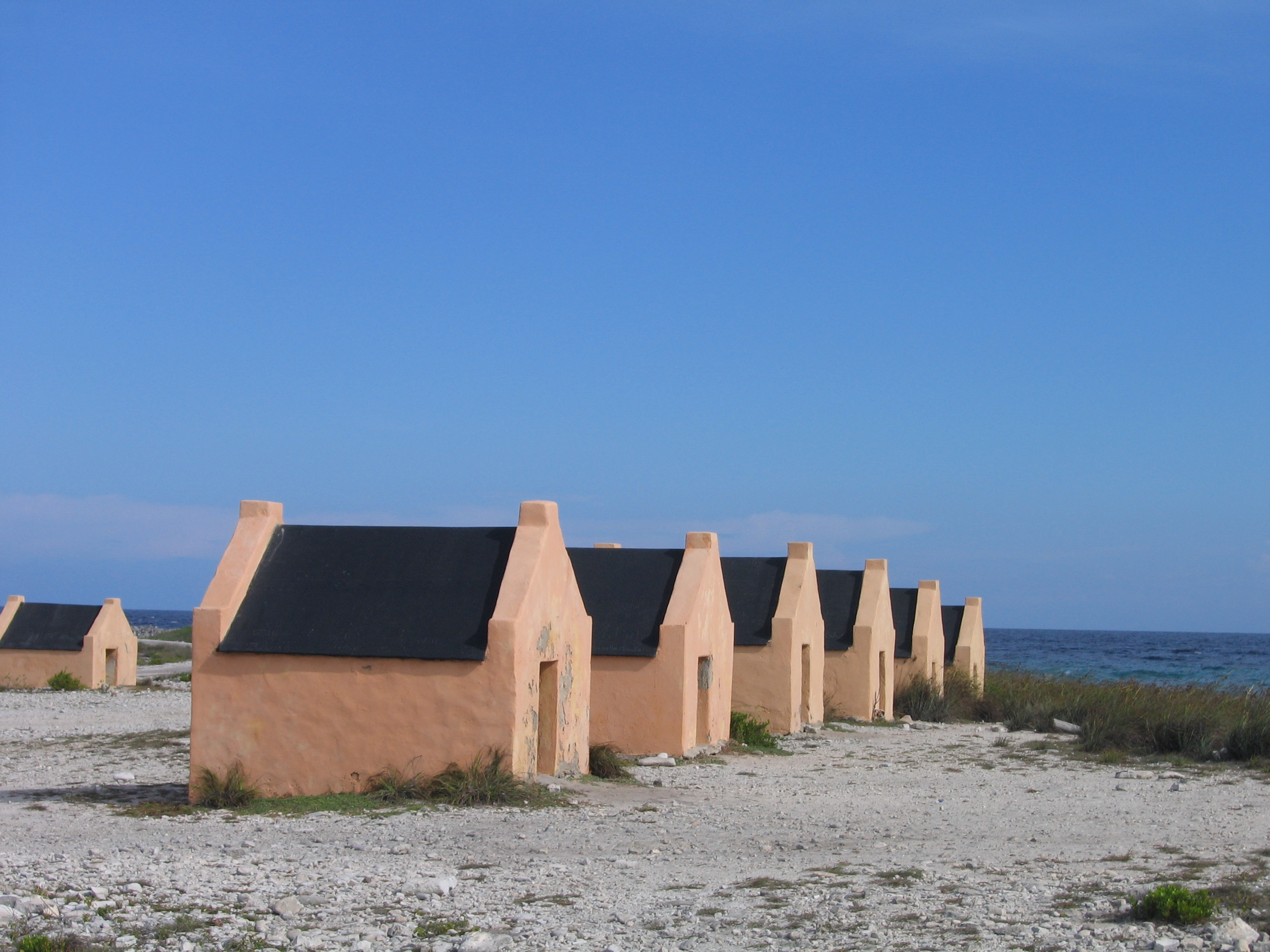
Salt, Stone, and Suffering
When the Dutch took control, Bonaire became a plantation of the Dutch West India Company, and salt became the island's primary export. Enslaved Africans were put to work alongside Indigenous people and convicts, harvesting solar salt around Blue Pan, cultivating dyewood, and growing maize. The stone quarters built to house enslaved workers still stand near Rincon and along the salt pans -- structures built entirely of stone, too short for a person to stand upright in. The slave population grew in the 1710s when famine and unrest on Curacao prompted the Dutch to relocate large numbers of enslaved people to Bonaire. From 1816 until 1868, Bonaire remained a government plantation. Emancipation came on 30 September 1862, when 607 government-held and 151 privately held enslaved people were freed. The stone quarters remain, a blunt and physical reminder of what the salt industry was built upon.
Where the Reef Begins at the Road
Bonaire's reefs are home to over 57 species of coral and more than 350 recorded fish species, and they start closer to shore than almost anywhere else in the Caribbean. The island's fringing reef system begins at the low-tide line, following the underwater topography downward. Tidal variations here are slight -- about 1.8 feet -- driven more by wind and pressure systems than by the moon. This means the coral grows right to the water's edge, and a diver can enter from the beach and be swimming over pristine reef within minutes. The Bonaire National Marine Park, established in 1979 with World Wide Fund for Nature support, protects the entire coastline of both Bonaire and nearby Klein Bonaire, from the high-water mark to a depth of 200 feet. STINAPA, the national park foundation, manages 89 officially named dive sites. In 2011, biologists discovered a new species of jellyfish in these waters -- the Bonaire banded box jellyfish, Tamoya ohboya, highly venomous and named with what appears to be a deliberate exclamation.
Pink, Wind, and Salt
Bonaire is home to one of only four nesting grounds for the Caribbean flamingo, located in the Pekelmeer at the island's southern tip, where no human entry is permitted. The flamingos are drawn by the same thing that has defined the island's economy for centuries: salt. The large condensing ponds that ring the crystallizer basins harbor brine shrimp, and the shrimp feed the flamingos, turning the industrial landscape of the salt works into a wildlife sanctuary. Salt production resumed in 1966 after a long hiatus, and part of the modern facility extends into the sea as Salt Pier, now one of the island's most popular dive sites. On the windward side, Lac Bay draws windsurfers from around the world with its shallow water and relentless trade winds. Five of the Professional Windsurfers Association's ten highest-ranked freestyle competitors are from Bonaire. At the bay's northern end, one of the best-preserved mangrove forests in the Caribbean provides habitat for kayakers and snorkelers alike.
A Dutch Municipality in the Tropics
Since 2010, when the Netherlands Antilles dissolved, Bonaire has been a special municipality of the Netherlands -- a public body with its own mayor, aldermen, and municipal council, governed under Dutch law but retaining its own culture and creole language. The majority of the island's 26,552 residents speak Papiamentu as their primary language, a creole born from the blending of Portuguese, Spanish, Dutch, and West African languages. Dutch is official but spoken as a first language by only about 15 percent of the population. In 2024, Bonaire's insular council voted to declare Papiamentu a regional language under the European Charter for Regional and Minority Languages. The island uses the US dollar rather than the euro, a pragmatic choice driven by Caribbean trade patterns. Washington Slagbaai National Park, a 5,643-hectare preserve on the northern tip, was the first nature park in the Netherlands Antilles when established in 1969. Its highest point, Mount Brandaris at 241 meters, offers a complete view of the island -- reef, salt pans, flamingos, and all.
From the Air
Bonaire sits at approximately 12.18N, 68.26W, about 80 km north of Venezuela's coast. The island is roughly 40 km long and 11 km wide, oriented north-south. From altitude, the southern salt pans and condensation ponds are the most striking visual feature -- geometric pink and white rectangles along the coast. Klein Bonaire, a small uninhabited islet, sits just offshore to the west. Flamingo International Airport (TNCB/BON) is located on the southern coast near Kralendijk. Approach from the west for the best view of the leeward reef system and the contrast between turquoise nearshore water and deep blue ocean. Recommended viewing altitude: 5,000-10,000 ft to see the full island geography. Conditions are typically clear with steady easterly trade winds.