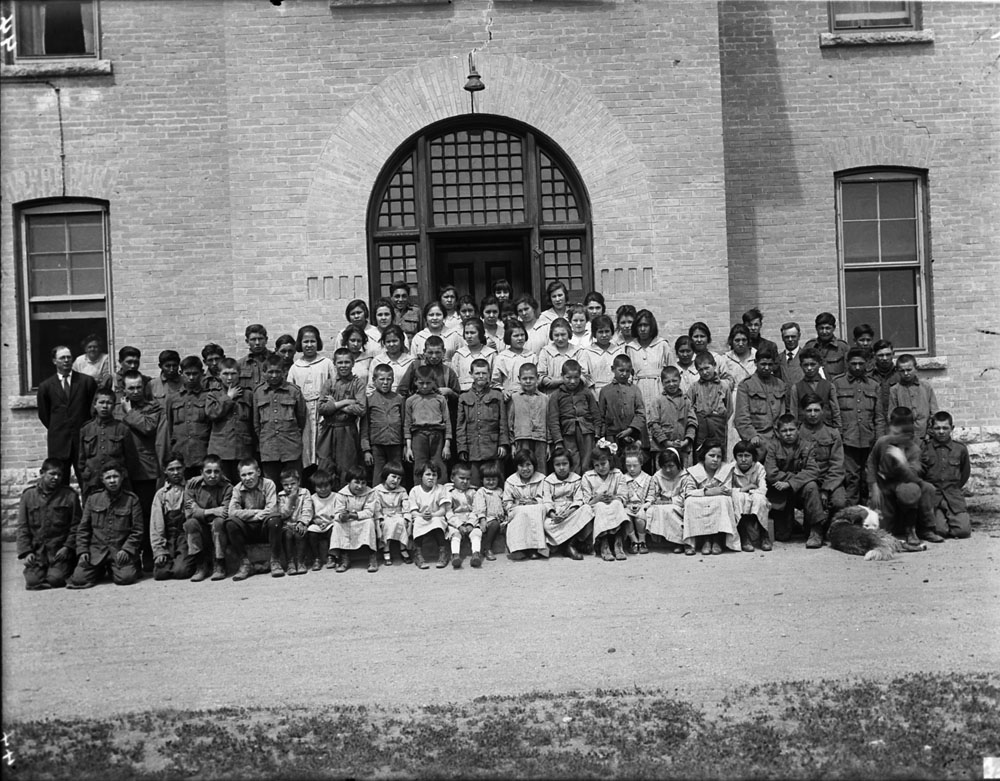
Brandon Indian Residential School
One of the burial grounds is now an RV campground. That single fact distills the complicated, painful history of the Brandon Indian Residential School, a place where Indigenous children were sent for seventy-seven years, where official records accounted for only nine registered deaths, and where ground-penetrating radar has since revealed scores of unmarked disturbances beneath the soil. Five kilometres northwest of Brandon, Manitoba, this institution operated from 1895 to 1972, part of the Canadian Indian residential school system that the Truth and Reconciliation Commission found responsible for the deaths of between 3,200 and 6,000 children nationwide over 120 years.
Seventy-Seven Years Behind Closed Doors
The Brandon Indian Institute opened in 1895, established by the Department of Indian Affairs to educate Indigenous children brought from communities north of Lake Winnipeg. The Mission Board of the Methodist Church managed the school for its first three decades, from 1895 to 1925. When the Methodist Church merged into the United Church of Canada, the new denomination took over operations until 1969. The Missionary Oblates of Mary Immaculate ran the school during its final three years before it closed in 1972. Across those seventy-seven years, the institution cycled through religious organizations, but the experience for the children inside followed the same grim pattern documented at residential schools across Canada: removal from families, suppression of language and culture, and conditions that too often proved fatal.
The Gap in the Records
The 1905 annual report of the Department of Indian Affairs noted five deaths at the Brandon school in that year alone. Methodist Church records from the same period counted three. Yet across the entire seventy-seven-year life of the institution, only nine deaths were ever registered with the Manitoba Vital Statistics Agency. The discrepancy speaks to a systemic failure of documentation that the Truth and Reconciliation Commission exposed on a national scale. Across all residential schools, the Commission found that the vast majority of deaths were caused by tuberculosis, concentrated in the decades before the TB vaccine became widely available in the 1950s. After vaccination programs were implemented, deaths at the schools dropped to near zero. But for the families of those earlier decades, the question of what happened to their children went unanswered for generations.
Searching Beneath the Surface
In 2012, the Sioux Valley Dakota Nation partnered with researchers from Simon Fraser University, Brandon University, and the University of Windsor to investigate the cemeteries at the Brandon school site. Their goal was straightforward and painful: identify the children buried there. Using ground-penetrating radar and archival research, the team identified 104 ground disturbances that may represent potential graves across three cemeteries. Historical cemetery and burial records account for only seventy-eight of these. Two cemeteries were previously known, but the investigation uncovered a possible third burial site. Whether the additional twenty-six anomalies detected by radar represent actual graves can only be confirmed through excavation. The project received funding to continue in April 2019, but the COVID-19 pandemic delayed further work.
What Stands There Now
The site of the Brandon Indian Residential School has been transformed by time and development. One of the burial grounds now lies beneath an RV campground, a fact that drew national attention when the Sioux Valley Dakota Nation's findings became public. Chief Jennifer Bone of the SVDN described the investigation as essential work, driven by the need to bring closure to families who never learned where their children were laid to rest. The juxtaposition of a recreational campground atop a children's cemetery captures something about how Canada's residential school history was, for decades, literally paved over. The ongoing investigation at Brandon stands as part of a larger national reckoning, one that the Truth and Reconciliation Commission set in motion and that communities across the country continue to carry forward.
From the Air
Located at 49.87N, 99.99W, five kilometres northwest of Brandon, Manitoba, Canada's wheat city and the province's second-largest urban centre. The nearest significant airport is Brandon Municipal Airport (CYBR). From the air, Brandon sits at the junction of the Assiniboine River and the surrounding agricultural prairie. The former school site is on the northwest outskirts of the city. Look for the broad, flat agricultural landscape of the Westman Region stretching in every direction.