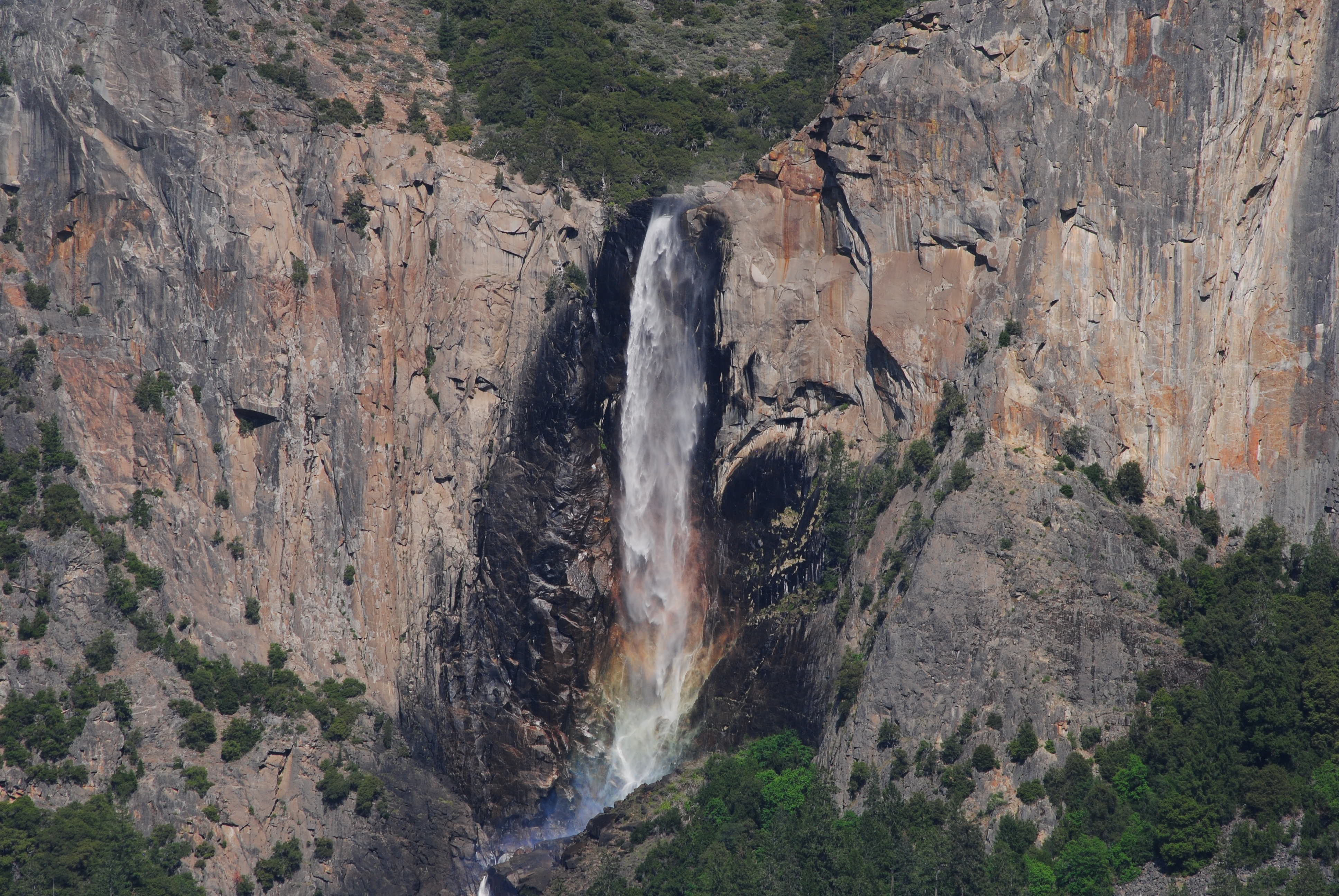
Bridalveil Fall
On a windy day, Bridalveil Fall does not fall. It drifts. Six hundred and twenty feet of water peel off the lip of a granite hanging valley and immediately lose their argument with the air. Gusts catch the stream and shove it sideways, shredding it into veils and curtains that twist against the cliff face. When the flow runs light in late summer, the water may dissolve into mist before it ever touches the rocks below - a waterfall that evaporates on the way down. The Ahwahneechee people, who lived in Yosemite Valley for centuries before European contact, understood this behavior perfectly. They named the fall Pohono: Spirit of the Puffing Wind. A newspaper editor from the mining town of Mariposa, arriving in 1856, saw something different in the delicate spray and offered the name Bridalveil. Both names are accurate. Both miss something the other catches.
Carved by Ice, Fed by a Distant Lake
Bridalveil Fall exists because of a geological mismatch. When Pleistocene glaciers ground through what is now Yosemite Valley, they carved the main canyon far deeper than the smaller tributary valleys feeding it from the sides. These side valleys were left stranded hundreds of feet above the valley floor - hanging valleys, in geological terms - and their streams had no choice but to leap off the edge. Most of Yosemite's waterfalls have since carved their hanging valleys into steep cascades, the water gradually eroding a staircase down to the main valley. But Bridalveil Creek still makes the full plunge, launching from a precipice that has retreated only slightly into an alcove from the original valley rim. The creek's primary source is Ostrander Lake, sixteen kilometers to the south, a glacially carved basin high in the backcountry that feeds the fall through a network of meadows and granite channels. Unlike many Yosemite waterfalls that dry to a trickle by August, Bridalveil flows year-round.
The Spirit and the Veil
The Ahwahneechee did not see Bridalveil as merely scenic. Pohono carried spiritual weight - the puffing wind was a presence, not just a weather pattern. The mist that swirls at the base of the fall, shifting and reforming with each gust, gave rise to stories of spirits inhabiting the spray. For centuries before the Mariposa Battalion marched into the valley in 1851, the Ahwahneechee lived among these waterfalls and granite walls, reading the landscape as text. Pohono was one chapter. When settlers arrived, they brought their own vocabulary. Warren Baer, a newspaper editor, suggested the name Bridalveil on August 5, 1856, struck by the lacy, translucent quality the water takes on when the flow drops in late summer. The name stuck, layering a Victorian sensibility over an indigenous understanding. Both framings respond to the same phenomenon - water made strange by wind - but the Ahwahneechee version centers the invisible force, while the settler version describes the visible result.
A Waterfall You Can Walk To
Bridalveil Fall is one of the first major sights visitors encounter when entering Yosemite Valley from the south. A short trail - roughly half a mile round trip - leads from a parking area to the base of the fall, making it one of the most accessible waterfalls in the park. This accessibility means it is also one of the most crowded, but the crowds thin as you approach the viewing area, where the mist that gives Pohono its name soaks anyone who stands too close. In spring, when snowmelt swells Bridalveil Creek, the fall thunders with a force that makes conversation difficult and the spray reaches visitors a hundred feet away. By September, the same waterfall whispers. The stream narrows to a silver thread that the wind toys with, pulling it apart and reassembling it against the granite. Photographers know this is the better season - the light plays through the thinned water in ways that the spring torrent obscures. Ansel Adams photographed it in both moods. The valley's changing character, season by season, is written most legibly in its waterfalls, and Bridalveil is the one you meet first.
The Hanging Valley's Edge
From the air, the geological story becomes legible in a way it never can from the valley floor. The main valley is a deep U-shaped trough, its walls sheared clean by ice. Bridalveil Creek approaches from the south through a shallower, gentler valley - the hanging valley - and then simply runs out of ground. The lip where the creek launches into space is visible as a sharp line where green meadow meets vertical granite. Yosemite Falls, on the north side of the valley, appears to follow the same pattern, but its original course actually ran down a gorge to the west of its current location. Bridalveil is the purer example: a stream that still leaps from the original edge of the glacial architecture, making it one of the best illustrations of hanging valley geology in the world. Stand at the base and look up, and you are seeing the exact line where a tributary glacier stopped and the main glacier kept digging. The waterfall is a diagram of deep time, annotated by wind.
From the Air
Located at 37.7168°N, 119.6465°W on the south wall of Yosemite Valley. The waterfall drops 620 feet (189 m) from a hanging valley into the main valley. Clearly visible from the air as a white streak on the granite south wall, especially in spring when flow is strongest. Nearest airports: Fresno Yosemite International (FAT), 65 miles south; Mariposa-Yosemite Airport (MPI), approximately 30 miles west. Best viewed at 3,000-5,000 ft AGL. El Capitan is visible to the northwest, and Cathedral Rocks frame the fall on either side.