The Longest Span
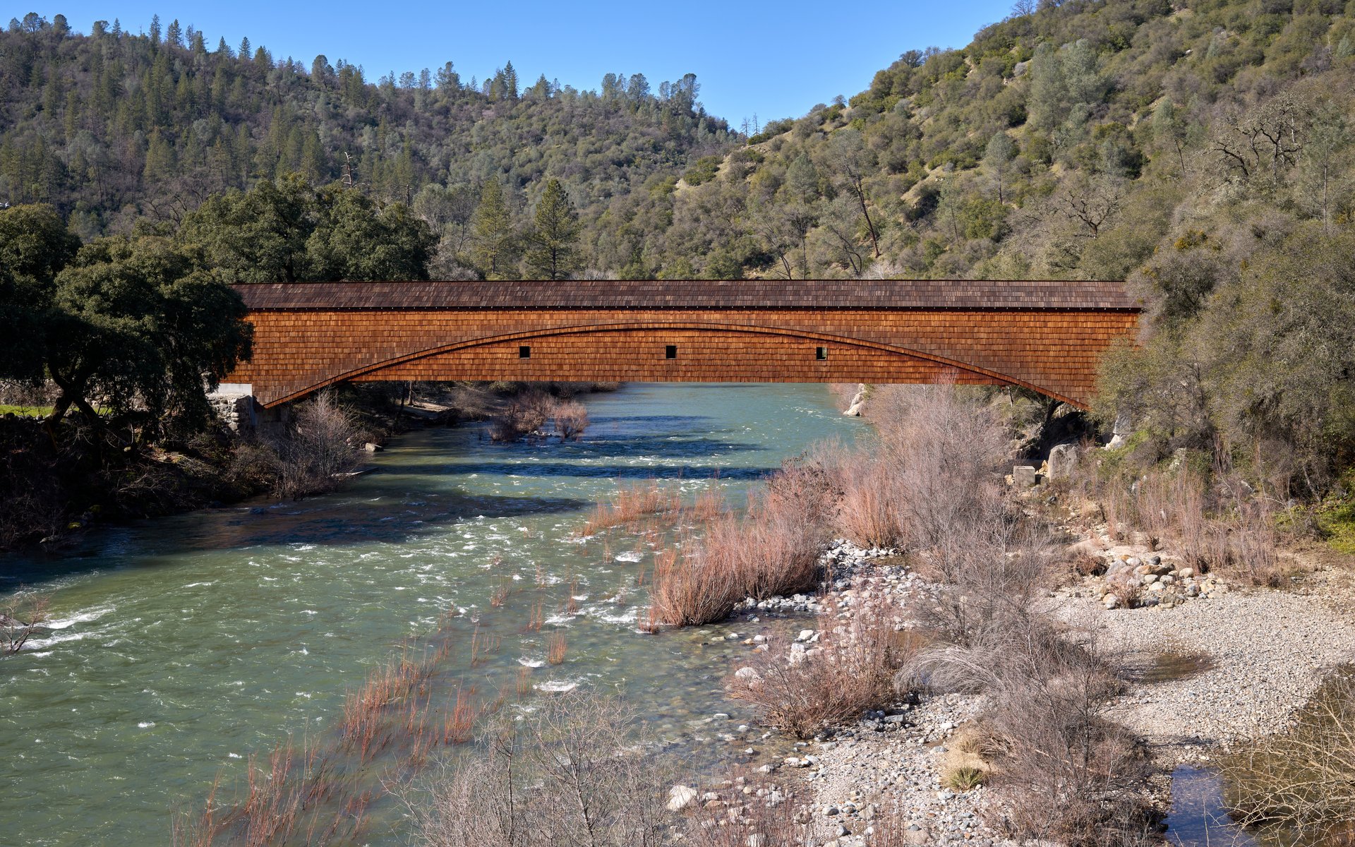
Two hundred and ten feet of timber, and not a single pier beneath it. The Bridgeport Covered Bridge hangs over the South Yuba River on nothing but geometry -- a combination truss-and-arch design that David John Wood devised in 1862, using lumber he milled himself in Plum Valley up in Sierra County. It is the longest clear single span of any surviving wooden covered bridge in the world, and it exists because silver was discovered three years earlier and sixty miles east, in a place called the Comstock Lode.
The Road to Virginia City
When the Comstock Lode erupted in 1859, the rush to Virginia City, Nevada created an urgent problem: how to move freight across the Sierra Nevada. The solution was a chain of roads, rivers, and bridges. Steamboats carried goods from San Francisco Bay up the Sacramento River to Marysville. There, teamsters loaded wagons and pushed east along the Virginia Turnpike and Henness Pass Road, climbing through the foothills and over the mountains. The Bridgeport crossing was a critical link in this chain -- the South Yuba River ran deep and fast through a steep gorge, and without a bridge, the route broke. Wood's covered bridge solved the problem with an elegance that outlasted the route itself. By 1868, the transcontinental railroad reached Reno via Donner Pass, and the wagon road began to fade. But the bridge endured, serving foothill communities long after the freight wagons stopped rolling.
Engineering Without Precedent
The bridge's claim to the world record is undisputed now, though it wasn't always. For decades, the Old Blenheim Bridge in New York matched it -- a U.S. Department of the Interior report documented Bridgeport's clear spans at 210 feet on one side and 208 feet on the other, while Old Blenheim measured 210 feet in the middle. Hurricane Irene destroyed Old Blenheim in 2011, though the bridge was later rebuilt and reopened in 2018 with a comparable span — the two structures now share the distinction of longest surviving wooden covered bridges. Historically, Pennsylvania's McCall's Ferry Bridge held the all-time record with a claimed clear span of 360 feet, but that structure lasted only two years before an ice jam destroyed it in 1817. What makes Bridgeport remarkable is not just the span but the survival. Its unique combination of truss and arch construction distributes load in a way that has withstood more than 160 years of Sierra weather, river floods, and human neglect.
Rescued from Ruin
By the early 1970s, the bridge could no longer support vehicles, and it was closed to car traffic in 1972. For nearly four decades it served pedestrians, its timbers slowly deteriorating. In 2011, structural problems forced a full closure -- even walking across became unsafe. The bridge sat silent over the Yuba, its future uncertain. Then in 2014, Governor Jerry Brown signed a state budget that included $1.3 million for restoration, a remarkable allocation for a single rural bridge. The work proceeded in two phases: first stabilization to halt the collapse, then full restoration to rebuild what had decayed. In November 2021, the bridge reopened to foot traffic, and California State Parks celebrated what they called 'a place of connection' -- linking not just the two banks of the river but the present to a Gold Rush past that most of California has paved over.
A Landmark in the Gorge
The bridge carries California Registered Historical Landmark designation number 390, a plaque first placed in 1964 and rededicated fifty years later during the restoration campaign. The inscription tells the story plainly: built in 1862, part of the Virginia Turnpike toll road, a lifeline across the Sierra Nevada. Today the bridge sits within the South Yuba River State Park, surrounded by oak woodlands and exposed granite, the river running clear below. It is one of the oldest housed spans in the western United States, and its survival is something like a minor miracle -- a wooden structure built during the Civil War, still standing in a state that has earthquakes, wildfires, and a habit of tearing down the old to build the new. From the bridge's deck, the only sounds are the river and the wind moving through the timbers.
From the Air
Located at 39.293N, 121.195W in the South Yuba River gorge, Nevada County, California. The covered bridge is visible at lower altitudes as a narrow wooden structure spanning a steep canyon. Best viewed below 3,000 feet AGL. Nearest airport is Nevada County Air Park (GOO, approximately 12 nm east). Auburn Municipal Airport (KAUN) is about 25 nm south. The South Yuba River canyon and surrounding oak-covered foothills are the primary visual landmarks.