Bright Angel Trail
For the better part of three decades, anyone who wanted to hike from the South Rim of the Grand Canyon to the Colorado River had to pay a dollar to a future United States senator. Ralph H. Cameron settled on the canyon rim in 1890, improved an old Havasupai trail all the way down to the river, and promptly began charging tolls, including extra fees for drinking water and the use of outhouses. The trail he named Bright Angel became the stage for one of the canyon's most colorful power struggles, involving a railway company, two entrepreneurial brothers, and the newly created National Park Service. More than a century later, the Bright Angel Trail remains the most popular route from rim to river, carrying hikers and mule trains 4,380 vertical feet through two billion years of exposed rock.
A Path Built by Water Seekers
The upper portion of the trail was originally constructed by the Havasupai people to reach the perennial water source of Garden Creek. The Havasupai settled seasonally in the area, farming and drawing from the creek in a green oasis now known as Havasupai Gardens. In 1903, President Theodore Roosevelt ordered the Havasupai to leave to make way for a park, but the last families were not forced out by the National Park Service until 1928. For decades the site was called Indian Garden, a name the Havasupai regarded as offensive and a painful reminder of displacement. In November 2022, the U.S. Board on Geographic Names approved the name change to Havasupai Gardens, and a public ceremony at the South Rim on May 5, 2023, with tribal members and park leaders, formally restored the name.
Toll Roads and Turf Wars
When Cameron took control of the trail, he charged a one-dollar toll that rankled everyone from tourists to the powerful Atchison, Topeka and Santa Fe Railway. In 1911, the railway fought back by improving an existing horsethief route in Hermit Canyon, creating the Hermit Trail as a free alternative. But Cameron held firm. In 1924, the newly established National Park Service began constructing the South Kaibab Trail near Yaki Point as yet another bypass around Cameron's fees. Legal battles dragged on until 1928, when the Bright Angel Trail was finally turned over to public control. Cameron, who served as a U.S. senator from Arizona between 1921 and 1927, lost both his political seat and his trail in quick succession.
The Brothers on the Rim
Ellsworth Kolb arrived at the Grand Canyon in 1901 to work as a bellboy at the Bright Angel Hotel. The next year he invited his brother Emery, lured by the prospect of mine work. When John Hance's asbestos mine closed before Emery arrived, the brothers pivoted. Emery bought a photography business in Williams, Arizona, and moved it to the canyon. They set up a tent studio on land leased from the Cameron family and began photographing visitors on mule rides down the trail. The business thrived. Within a few years they blasted rock from the canyon rim to lay the foundation for a permanent studio perched just below rim level. Ellsworth departed in 1924, but Emery operated the studio until his death in 1976. Today the Kolb Studio serves as a gift shop, art gallery, and history center run by the Grand Canyon Association.
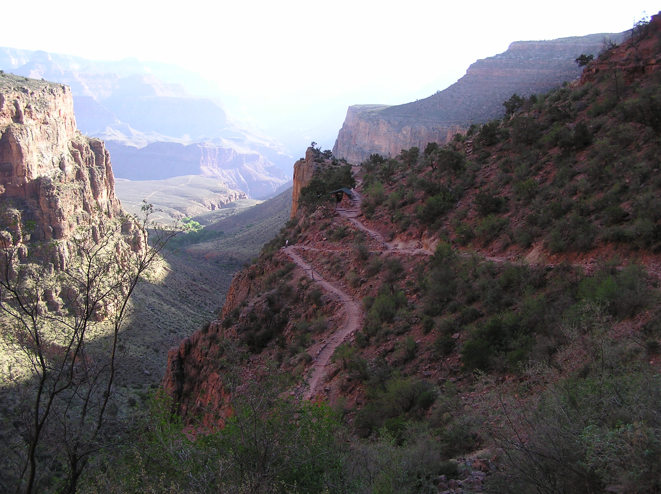
The Descent Itself
From Grand Canyon Village on the South Rim, the trail drops 4,380 feet to the Colorado River at an average grade of 10 percent, though more than two-thirds of the elevation change occurs in the first stretch down to Havasupai Gardens. Water flows from the trans-canyon pipeline at the Mile-and-a-Half Resthouse, the Three Mile Resthouse, and Havasupai Gardens, although the upper resthouses shut off during cooler months to prevent freezing. Below Havasupai Gardens, Garden Creek and Pipe Creek flow year-round. The trail intersects the Tonto Trail, which connects westward and eastward across the canyon's midsection, eventually reaching the South Kaibab Trail. At the river, the River Trail continues to Bright Angel Campground and Phantom Ranch. Together these two trails form the most common rim-to-river route for hikers and mule trains alike.
Respect the Canyon
The National Park Service classifies the Bright Angel Trail as a corridor trail, meaning it receives regular maintenance and ranger patrols. That designation does not make it safe for the unprepared. Hazards include dehydration, extreme heat that can exceed 110 degrees Fahrenheit at the river, flash flooding, bootpacked ice in winter, loose footing, and rockfall. The Colorado River itself adds risks of hypothermia from its consistently cold temperatures and drowning in rapids. Mule trains have right of way on the narrow switchbacks. Overnight camping requires a free backcountry permit, available up to four months in advance, with group sizes capped. The canyon demands planning, water discipline, and the humility to turn around when conditions say so.
From the Air
Located at 36.06N, 112.14W on the South Rim of the Grand Canyon. The trailhead is at Grand Canyon Village, clearly visible from altitude near the canyon's widest section. Nearest airport is Grand Canyon National Park Airport (KGCN), about 7 miles south of the rim. Phantom Ranch and the Bright Angel Campground sit at the canyon floor near the Colorado River and the Silver Bridge crossing. The trail's switchbacks are visible on the canyon walls. Elevation drops from approximately 6,860 feet at the rim to 2,480 feet at the river.