Buffalo Bill Dam
In 1937, two workers tunneling through rock for the Heart Mountain Canal project were overcome by fumes from explosives and hydrogen sulfide seeping from nearby geothermal vents. Disoriented in the toxic haze, they were struck by construction equipment and killed. Building in Shoshone Canyon has always come with risks. The dam that towers here today began as the Shoshone Dam, designed by engineer Daniel Webster Cole and constructed between 1905 and 1910. When completed, it stood as the tallest dam in the world. In 1946 it was renamed to honor William F. Cody, the showman and town founder who had championed development of this region. The structure earned a place on the National Register of Historic Places in 1971.
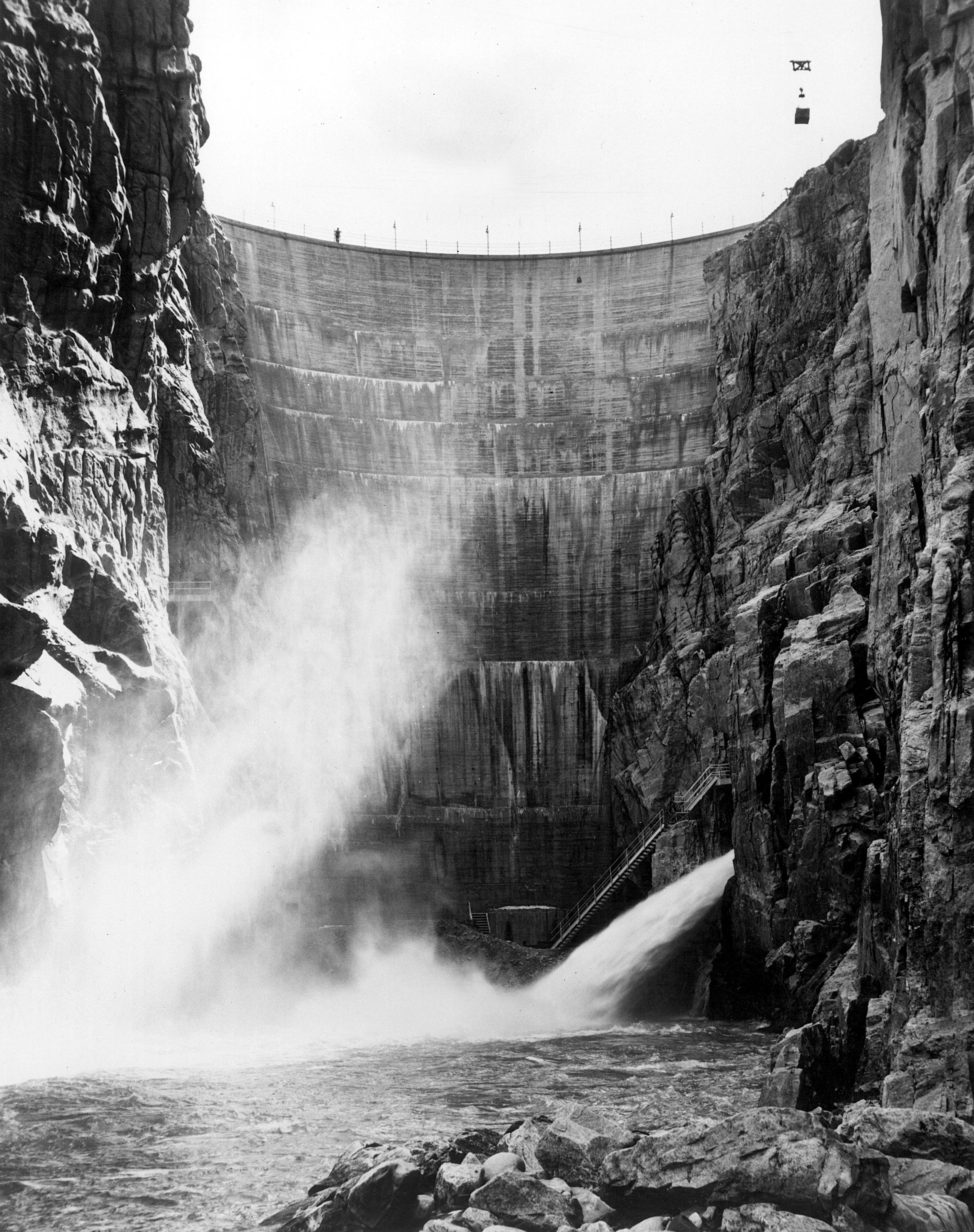
Anchored in Ancient Rock
The dam is a concrete arch-gravity design, its curved face transferring the weight of billions of gallons of water into the Pre-Cambrian granitic walls of the canyon on either side. These rocks are among the oldest exposed formations in North America, providing an anchor point that has held for over a century. The spillway, an uncontrolled overflow weir on the south side, drops through a tunnel blasted through the south abutment. When the reservoir fills beyond capacity, water simply sheets over the weir and plunges into the tunnel, emerging downstream in a controlled rush. The land around the reservoir is maintained as Buffalo Bill State Park, where the high desert gives way to water sports and camping.
Power from the Canyon
Work on the Shoshone Power Plant began in 1920. Located downstream from the dam on the north side of the canyon, it was operational by 1922 following delays caused by spring flooding. The power plant marked the beginning of hydroelectric development that would eventually see three separate generating facilities draw energy from these waters. The Heart Mountain Canal project, which claimed those two lives in 1937, required the Shoshone Canyon Tunnel to direct irrigation water to suitable elevations for distribution. Workers from the Utah Construction Company had to cross a natural cave by constructing a concrete flume, built under difficult conditions in an environment thick with dangerous gases. The tunnel was completed in 1939.
Making a Tall Dam Taller
Between 1985 and 1993, engineers returned to raise the dam's crest by 25 feet. The project increased the reservoir's capacity substantially and added 25.5 megawatts of generating capacity. New spillways were equipped with radial arm gates for better flood control. A visitor center was constructed at the north end of the dam's crest, offering views down the canyon face. The rising waters flooded facilities at Buffalo Bill State Park, requiring their relocation and reconstruction. Today you can stand at the visitor center and look down at more than a century of engineering ambition, the original 1910 structure visible beneath the 1993 addition like geological strata recording human determination.
Three Power Plants
The Buffalo Bill Power Plant was built in 1992 alongside the dam heightening project. Located in Shoshone Canyon downstream from the original Shoshone Powerplant, it operates three Francis turbines with generators rated at 6 megawatts each. Two years later, in 1994, the Spirit Mountain Powerplant came online. This facility serves a different purpose: it receives pressurized water through a conduit and primarily functions to dissipate that pressure before the water enters an open canal. Generating 4.5 megawatts on a seasonal basis is essentially a byproduct of the pressure reduction. Together with the original 1922 Shoshone Power Plant, these three facilities represent nearly a century of extracting energy from water that flows from Yellowstone's high country toward the Great Plains.
From the Air
Buffalo Bill Dam is located at 44.50N, 109.18W in Shoshone Canyon approximately 6 nm west of Cody, Wyoming. The dam is highly visible from the air, a white concrete arc spanning the narrow canyon with Buffalo Bill Reservoir extending upstream to the west. US Highway 14/16/20 crosses directly over the dam crest. The dramatic canyon walls and the contrast between blue reservoir water and brown desert terrain make this an unmistakable landmark. Yellowstone Regional Airport (KCOD) is approximately 8 nm east. The Absaroka Range rises to the west beyond the reservoir.