Bushrod Island
The island is named for a man who never set foot on it. Bushrod Washington, nephew of George Washington and first president of the American Colonization Society, lent his name to a flat slab of mangrove and mud at the edge of Monrovia where the Saint Paul River, the Mesurado River, and the Atlantic Ocean all converge. The ACS had a singular mission in the early nineteenth century: relocate free and enslaved African Americans to West Africa. The island that carries Washington's name became one of the places where that fraught experiment in repatriation played out, layered on top of centuries of indigenous habitation and reshaped by commerce, war, and the constant pressure of water on all sides.
Before the Name
Long before the American Colonization Society drew its maps, the Dei people held Bushrod Island. They occupied the low-lying mangrove swampland from the sixteenth century onward, building their chief settlement at Gawulun, which served as the capital of the Dei confederation. In 1819, a leader known as King Peter, whose Dei name was Zolu Duma, was selected as chief spokesman for the island's Dei chiefs. The Dei were among the indigenous groups who watched the arrival of the ACS-sponsored settlers with a mixture of commerce and caution, their own political structures already well established on land that the newcomers would eventually claim and rename. The encounter between the Dei and the settlers was not a simple displacement but a long, uneven negotiation whose terms kept shifting as the colony of Liberia took shape around them.
Freed Twice, Settled Once
In the late 1820s, a community called New Georgia appeared on Bushrod Island. Its founders were people who had been rescued from a slave ship in 1820, then held in the U.S. state of Georgia for seven years before being sent to Liberia. The name they chose honored the American state that had sheltered them, even as they crossed an ocean to build something new. By 1878, New Georgia had grown to about five hundred residents, coexisting on the island with a community of Vai people whose settlement, known as Vai Town, sat across the Mesurado River from Monrovia proper. The arrangement was a small-scale model of Liberia's larger complexity: indigenous groups, formerly enslaved Americans, and people freed from slave ships all occupying the same territory, each with different claims to belonging.
Port and Pulse
Today, Bushrod Island's defining feature is the Freeport of Monrovia, Liberia's principal deepwater port and the commercial artery through which most of the country's imports and exports flow. The port shares the island with four distinct towns: Vai Town, New Kru Town, Logan Town, and Clara Town, each with its own character and history. Residential neighborhoods crowd against government buildings and small businesses. End Point, a geographical feature at the island's northern tip, marks where the Saint Paul River widens toward the sea. The proximity to Monrovia's city center, connected by bridges across the Mesurado River and Stockton Creek, makes Bushrod Island an extension of the capital rather than a separate entity. Much of the island sits barely above sea level, and the tidal influence of Stockton Creek, which links the Saint Paul and Mesurado rivers, keeps the boundary between land and water perpetually negotiable.
The Weight of a Name
Bushrod Washington never traveled to Liberia. He served as a U.S. Supreme Court justice and managed Mount Vernon after his uncle's death, but his most consequential legacy may be the organization he led. The American Colonization Society operated from a tangle of motivations: some members genuinely sought to offer formerly enslaved people a path to self-governance, while others wanted to remove free Black Americans from a society that refused to grant them equality. Liberia itself was the result, a nation whose capital, Monrovia, is named for another ACS-affiliated president, James Monroe. The island that bears Bushrod Washington's name sits at the literal foundation of that project. Its mangrove roots hold the sediment in place while the rivers shift around them, a geography that mirrors the island's history: layered, contested, and stubbornly present.
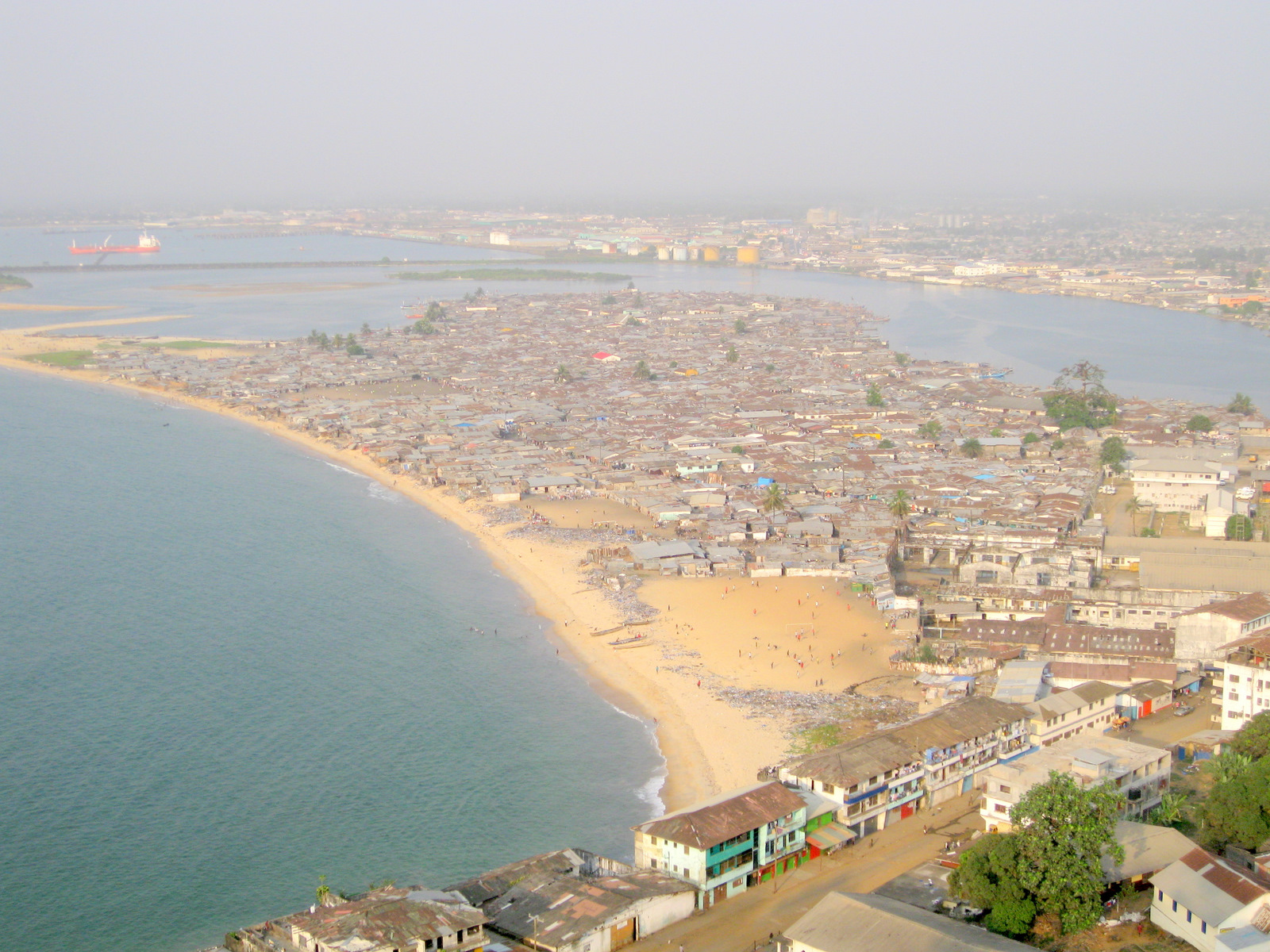
From the Air
Located at 6.358N, 10.783W, Bushrod Island is clearly visible from altitude as the landmass north of central Monrovia, bounded by the Atlantic Ocean to the west, the Saint Paul River to the north and east, the Mesurado River to the south, and Stockton Creek connecting the two rivers. The Freeport of Monrovia's docks and container facilities are prominent landmarks on the island's western shore. Nearest airport is Spriggs Payne Airport (GLSP), approximately 3 km south across the Mesurado River. Roberts International Airport (GLRB) is about 56 km southeast. Recommended viewing altitude: 2,000-3,000 feet to see the island's shape and river boundaries. Low-lying terrain; tidal flooding possible.