Busselton Jetty
Walk to the end of Busselton Jetty and you are nearly two kilometers from shore. The timber planks stretch behind you in a narrowing line toward the coast, the rails of a small train track running between your feet. Below, eight meters down through the water, an underwater observatory offers windows into a coral reef that has colonized the jetty's pilings. It is a strange and wonderful structure -- 1,841 meters of timber reaching into Geographe Bay -- and it exists today only because the people of Busselton fought cyclones, fires, wood borers, government indifference, and their own fundraising limitations to keep it standing.
From Vasse Jetty to the Longest Pier
The jetty began as a practical necessity. In 1839, Governor John Hutt designated the spot in Geographe Bay opposite the Vasse settlement as the legal place for loading and unloading goods. Construction did not start until 1864, after persistent lobbying by settlers including timber merchant Henry Yelverton and magistrate Joseph Strelley Harris. Yelverton's company won the construction tender, and the first 176-meter section opened in 1865. Extensions came steadily over the following century as the port's commercial importance grew. By the 1960s the jetty had reached its full length of 1,841 meters -- the longest timber-piled jetty in the Southern Hemisphere. A rail line connected it to the broader railway network running into Busselton from Bunbury, and for more than a hundred years ships called at its end to take on timber, dairy products, and other goods from the fertile southwest.
Cyclone, Fire, and Neglect
The last commercial ship docked at Busselton Jetty on 17 October 1971. On 21 July 1972, a Governor's Proclamation in the Western Australian Government Gazette officially closed the jetty to shipping after more than a century of use. Government maintenance ceased immediately, and the structure began to deteriorate. Wood borers attacked the pilings. Rot crept through the timbers. Fires broke out periodically, some blamed on fishermen's cigarettes, others on sparks from the old train. Then, on 4 April 1978, Cyclone Alby swept south down the coast from the northwest -- a rare track for a tropical cyclone -- and destroyed a large section of the shore end. The damage was devastating, but it also galvanized the town. Residents banded together and pressured the state government and shire council to fund repairs. When that money ran out, a Jetty Preservation Committee formed in 1987 to take on the task. In December 1999, fire burned 65 meters of the jetty to the waterline, causing $900,000 in damage.
A Community Saves Its Jetty
By 2001, the Preservation Committee had raised just A$14,000 -- roughly A$1,000 per year since its founding. That year, a new community organization called The Busselton Challenge stepped in and helped the committee redesign its fundraising approach. The results were extraordinary: A$220,000 raised in six months, a rate 440 times what had come before. An Interpretive Centre and museum opened near the shore end in April 2001. On 13 December 2003, the underwater observatory opened at the jetty's far end, descending eight meters below sea level into a 9.5-meter-diameter observation chamber with eleven viewing windows looking out onto the reef. It cost A$3.6 million and became one of only six natural underwater observatories in the world. A full A$27 million refurbishment brought the jetty into the State Register of Heritage Places, and in 2011 the restored pier and railway reopened. The old diesel train was replaced with a solar-powered electric vehicle in 2017.
Below the Surface
The jetty's most recent chapter involves what grows beneath it. The wooden pilings, submerged for over a century and a half, have become an artificial reef supporting rich marine life -- corals, sponges, fish communities that thrive in the sheltered waters of Geographe Bay. In 2023, thirteen underwater sculptures by Western Australian artists were installed beneath and alongside the jetty, creating a diving trail that doubles as habitat. A Marine Discovery Centre opened onshore in July 2024, offering interactive exhibits about Australia's offshore marine parks. Plans for a A$32 million whale-shaped Australian Underwater Discovery Centre were shelved in 2022 after pandemic-era cost blowouts, but the jetty continues to evolve. From above, it is a thin line of timber crossing turquoise water. From below, it is a living reef. From the story of its survival, it is proof that a community's attachment to a structure can be more durable than the structure itself.
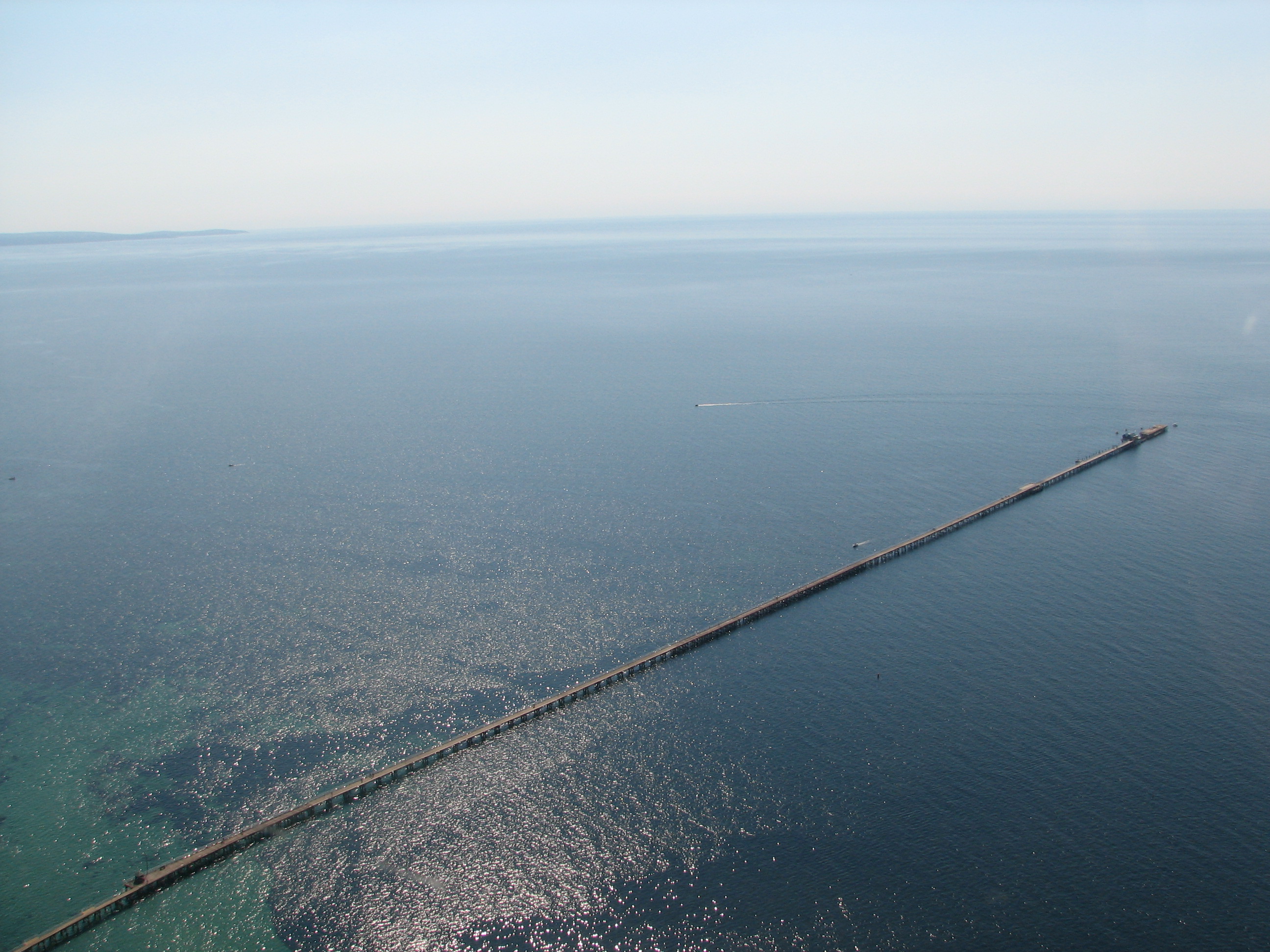
From the Air
Located at 33.64S, 115.34E in Geographe Bay, Busselton, Western Australia. The jetty is unmistakable from the air -- a thin line extending 1,841 meters into the bay from the Busselton foreshore. At low altitude, the underwater observatory structure is visible near the jetty's end. Busselton Margaret River Regional Airport (YBLN) is approximately 10 km to the east. The broad sweep of Geographe Bay, the town grid of Busselton, and Cape Naturaliste to the northwest are prominent visual landmarks. Best viewed at 1,000-3,000 ft for the full length of the jetty against the turquoise water.