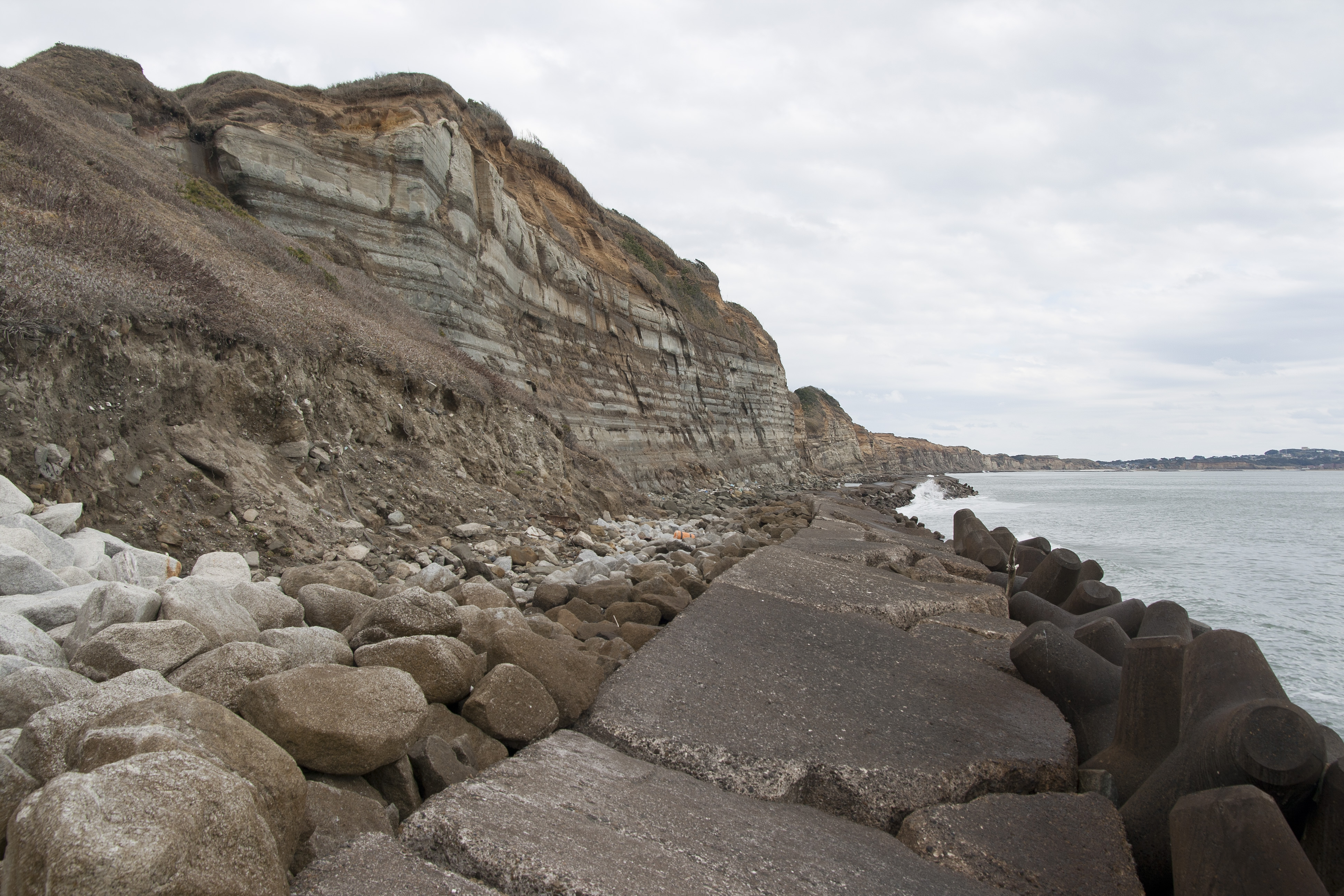
Byōbugaura
The Japanese call them byōbu -- folding screens, those elegant painted panels that divide rooms in traditional homes. Stand at the water's edge on the northeast coast of Chiba Prefecture and the name makes instant sense. For 10 kilometers, from Cape Inubō in Chōshi south to Cape Gyōbumi in Asahi, a wall of striped cliffs rises up to 50 meters above the Pacific surf, its banded face as layered and ornamental as any painted screen. The resemblance to another famous coastline earned Byōbugaura a second nickname: Tōyō no Dōbā, the Dover of the East. But unlike the chalk cliffs of the English Channel, these cliffs carry the geological fingerprints of Japan's most famous volcanoes -- and the Pacific Ocean is steadily dismantling them.
Volcanoes on a Cliff Face
The stripes tell the story. Four distinct geological strata are stacked across the cliff face like chapters in a textbook. At the top, the reddish Kantō Loam Stratum glows warm in afternoon light -- this layer is composed of volcanic ash deposited by eruptions of Mount Fuji and Mount Hakone, carried east on prevailing winds and settled over millennia. Beneath it sits the Katori Stratum, a middle band of transitional material. The most striking layer is the chalky-white Iioka Stratum that dominates the cliff face, giving Byōbugaura its Dover comparison. At the base, the Naarai Stratum meets the churning waterline. Each layer records a different era of deposition, each mineral composition shaped by different geological events. From the air, the color banding is unmistakable: red to brown to white to gray, a cross-section of the Kantō region's volcanic and sedimentary past laid open for inspection.
The Retreating Shoreline
Byōbugaura is beautiful, and Byōbugaura is vanishing. The white Iioka Stratum that gives the cliffs their dramatic appearance is composed of soft, easily eroded clay, and the Pacific Ocean exploits this weakness with relentless efficiency. Over the past 700 years, roughly 6 kilometers of land have been lost to marine erosion along this coast. Modern measurements sharpen the picture: between 1888 and 1951, 30 meters of shoreline retreated into the sea -- a pace of nearly half a meter per year. Current erosion rates run between 50 and 100 centimeters annually. The near-constant violent waves of the open Pacific pound the cliff base, undercutting the soft strata until gravity brings the upper layers crashing down. Since 1966, wave-dissipating levees and rows of concrete tetrapods have been installed along the base of the cliffs to slow the retreat, and they have softened the pace of land loss. But the ocean's work continues.
Folding Screen, Open Book
Byōbugaura forms the southernmost boundary of Suigō-Tsukuba Quasi-National Park, connecting the dramatic headlands of Chōshi to the long arc of Kujūkuri Beach, which stretches down much of the prefecture's Pacific coastline. Above the cliffs, the flat terrain tells a quieter story. The headland around Cape Inubō is cultivated for cabbage production, and the farmland extending inland from the cliff edge supports the agricultural economy that has sustained communities here long before tourists came to admire the view. The name itself captures the dual nature of this coast: byōbu for the visual spectacle, ura for the inlet's sheltering geography. Visitors can reach the cliffs by bus from JR Chōshi Station, alighting at the Chōshi Marina stop where the full sweep of the striped wall opens before them.
A Coastline Against the Clock
Byōbugaura poses a question that coastal communities worldwide increasingly face: how do you protect a landscape whose beauty depends on the very process that destroys it? The erosion that sculpts the dramatic cliff faces is the same force consuming the land above them. The tetrapod barriers and levees installed since the 1960s represent a compromise -- slowing the retreat enough to protect roads and farmland while accepting that the coastline will continue to evolve. For now, the striped cliffs still stand tall enough to earn their comparison to Dover, their volcanic reds and sedimentary whites catching the Pacific light. But the clock is always running, and each winter storm reshapes the screen a little more.
From the Air
Located at 35.703°N, 140.788°E on the northeast coast of Chiba Prefecture, Japan. The 10-kilometer cliff wall is a striking visual feature from the air, running roughly north-south with distinctive color banding (red-brown-white) visible from moderate altitudes. The cliffs extend from Cape Inubō southward to Cape Gyōbumi. Look for the rows of concrete tetrapods along the cliff base as a confirming landmark. Nearest airport: Narita International Airport (RJAA) approximately 50 km to the west-northwest. Kujūkuri Beach extends south from the cliff system along the coast. Winds off the Pacific can be strong and turbulent along this exposed coastline.