Cabo da Roca
Stand at Cabo da Roca and everything east of you is continent -- the entirety of Europe and Asia stretching unbroken to the Pacific coast of Kamchatka. Everything west is ocean. This is the westernmost point of mainland Portugal, of continental Europe, and of the entire Eurasian landmass. The Romans called it Promontorium Magnum -- the Great Promontory -- and they were not exaggerating. The headland marks the final western plunge of the Sintra Mountain Range, where ancient eruptive rock meets the Atlantic in cliffs of rose-colored granite and syenite.
Geology at Land's End
The rocks at Cabo da Roca tell a story of volcanic violence. The promontory represents the extreme western immersion of the ancient Sintra massif, an eruptive formation that pushed through the surrounding sedimentary layers millions of years ago. Rose-colored granite dominates the northern exposures, while syenite -- a coarse-grained rock similar to granite but without quartz -- characterizes the Ribeira do Lourical to the south. Between and around these formations, geologists find gabbro-diorite, volcanic breccia, and granite in various states of coastal erosion. Some granite faces have been carved smooth by wind and spray, while in other areas limestone deposits sit embedded within the igneous rock, a geological layer cake compressed and tilted by forces operating on timescales that make human history seem trivial.
The Invasion Nobody Planned
Cabo da Roca's native vegetation was once diverse -- low-lying plants adapted to salt spray and relentless wind, species shaped by the Atlantic's moods over millennia. Then someone introduced Carpobrotus edulis, a creeping succulent from South Africa, as ornamental ground cover. The ice plant, as it is commonly known, was a member of the Aizoaceae family, and it thrived in exactly the conditions that challenged native species. It spread with the determination of an occupying army, forming dense mats that smothered everything beneath. Today, much of Cabo da Roca's arable land lies beneath this invasive carpet. The original plant communities survive in patches, but the landscape that the Romans saw when they named this place is largely gone. Migratory and marine birds still roost along the cliffs and in protected coves, indifferent to the botanical transformation happening on the headland above them.
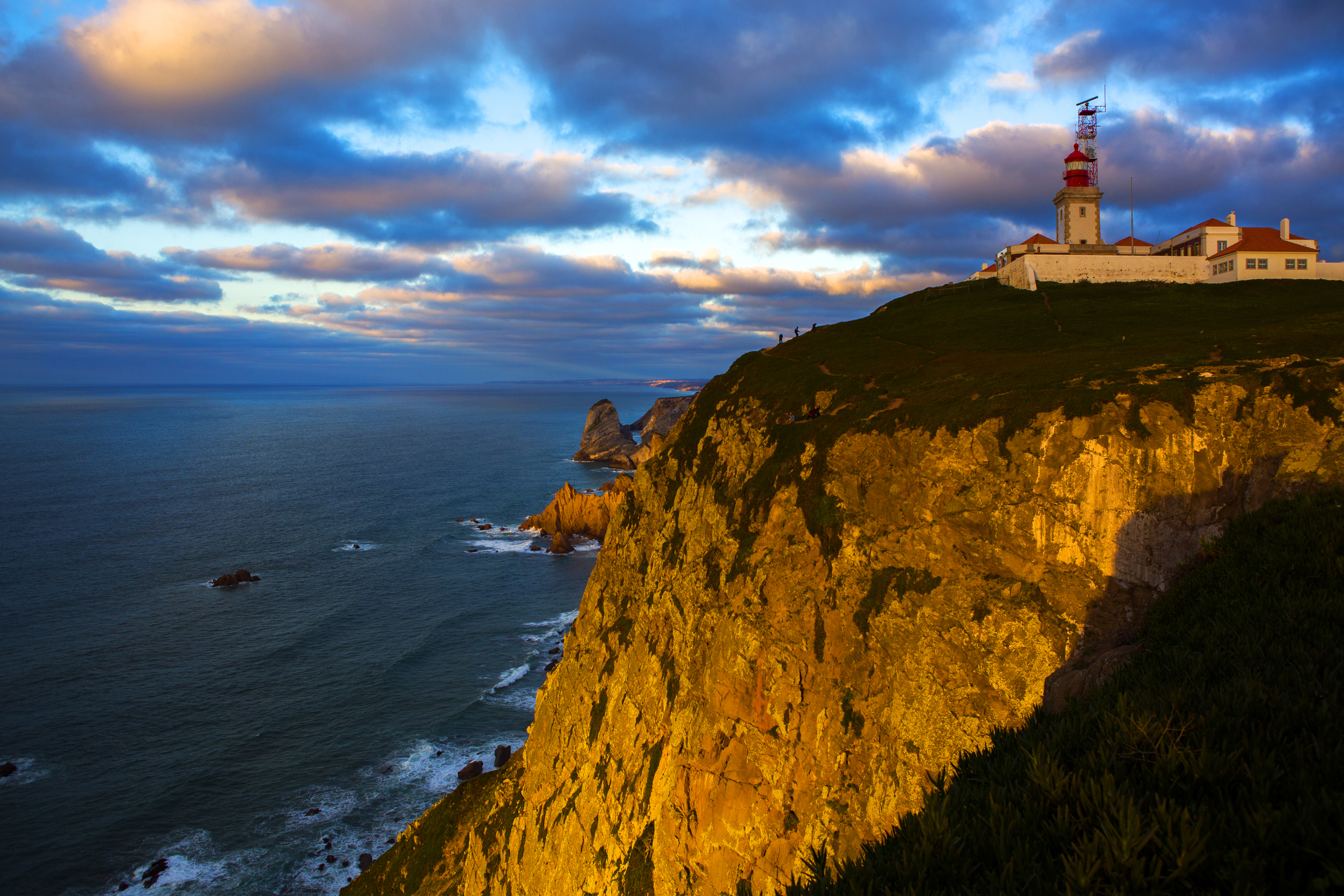
Where Fog Defeats Summer
The climate at Cabo da Roca defies the expectations that most visitors bring to Portugal. Summers are cool and stable, with little rainfall but near-constant fog generated by seasonal upwelling of cold water from the ocean depths. July and August bring the year's strongest winds, averaging around fifteen kilometers per hour, and the humidity remains high even when the sun never breaks through. September is warmer than July -- a counterintuitive consequence of seasonal lag in the ocean's temperature cycle. Winters bring rain and mild nighttime temperatures, though rainfall amounts are modest compared to the Sintra Mountains just a few kilometers inland, which can receive triple the precipitation. The lighthouse that stands at the cape has operated since 1772, its beam cutting through the fog that defined this headland's character long before anyone thought to measure it.
The Edge of the Known World
Every geographic extreme carries symbolic weight, and Cabo da Roca has accumulated more than most. For the Romans, it was as far west as land went. For medieval European cartographers, it was the boundary between the mapped and the imagined. For the Portuguese navigators who launched the Age of Discoveries, this cape was the last glimpse of home -- the final European headland visible from the deck of a caravel sailing south toward Africa or west toward Brazil. Today the cape sits within the municipality of Sintra, near the village of Azoia, about forty kilometers west of Lisbon. Visitors come for the views and the certificate -- the local tourist office issues documents confirming that the bearer has stood at continental Europe's westernmost point. The cliffs drop precipitously to the ocean below, and on clear days the light has a quality that painters and photographers have tried to capture for centuries: sharp, Atlantic, clarifying. On foggy days, which are frequent, the promontory disappears into whiteness, and the continent simply stops.
From the Air
Located at 38.78N, 9.50W, the westernmost point of mainland Europe. The cape is a prominent headland with a lighthouse, easily identifiable from the air as the Sintra Mountains' final plunge into the Atlantic. Sheer cliffs and the lighthouse tower make it unmistakable. Recommended viewing altitude: 2,000-4,000 feet for dramatic coastal perspective. Nearest airports: Lisbon Humberto Delgado (LPPT), approximately 20 nm east; Cascais aerodrome (LPCS) is closer at about 10 nm southeast. Fog is extremely common, especially in summer mornings. Strong winds year-round.