Cabo de Hornos National Park
The wind at Cape Horn averages 30 kilometers per hour with gusts regularly reaching 100. In storms, it can exceed 150. Waves build across the unbroken Southern Ocean, gathering force from 30,000 kilometers of fetch, then slam into this jutting headland where two oceans collide. For centuries, every ship traveling between Atlantic and Pacific had to round this rock - and thousands failed. The sailors who drowned here have no graves; their ships went down in waters too deep, too cold, too violent for recovery. Now Cape Horn lies within Chile's southernmost national park, protected land at the uttermost end of the Earth, where an albatross sculpture commemorates the dead and a lighthouse keeper's family lives in one of the loneliest postings on the planet.
The Uttermost Cape
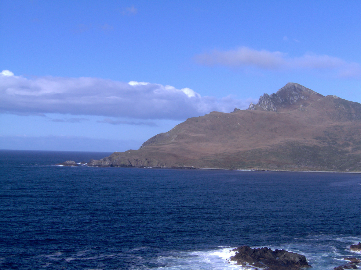
Cape Horn is not, technically, the southernmost point of South America - that honor belongs to Diego Ramírez Islands, 100 kilometers further south. But Cape Horn is where the land ends in a way that matters. The 425-meter cliffs of Isla Hornos rise from the sea like a wall, and beyond them lies only the Drake Passage - 800 kilometers of the roughest ocean on Earth before Antarctica's ice begins.
The first European to round the cape was Dutch explorer Willem Schouten in 1616, who named it for his hometown of Hoorn. The discovery transformed global trade: ships could now sail between Atlantic and Pacific without navigating the treacherous Strait of Magellan. But the cape extracted its toll. The constant westerlies, the mountainous seas, the cold that numbed hands and minds - rounding Cape Horn became the ultimate test of seamanship. The Flying Dutchman legend was born here, in stories of ghost ships forever trying to beat into the wind.
The Sailors' Graveyard
No one knows how many ships went down at Cape Horn. Estimates range from 800 to over 10,000 vessels, with perhaps 100,000 lives lost over the centuries. The currents here collide - Pacific pushing east, Atlantic pushing west - creating standing waves that can reach 30 meters. Add hurricane-force winds, freezing spray, icebergs drifting up from Antarctica, and fog that appears without warning, and you have conditions that sank ships of every era and design.
The wrecks lie in water too deep and too turbulent for recovery. The sailors have no monuments except the sea itself - and the sculpture that now stands near the lighthouse: an albatross in flight, wings spread wide, silhouetted against the sky. A poem engraved in stone remembers those who died rounding the Horn: 'I, the albatross that waits for you at the end of the world.'
The Lighthouse Keepers
On Isla Hornos, a Chilean naval family maintains the lighthouse - one of the most isolated postings in any military service. They stay for a year at a time: a naval officer, his wife, often children. Their home is a small complex of buildings on the island's eastern side, facing the Horn itself. They monitor weather, assist the rare expedition cruise that lands in calm weather, and tend the light that still guides ships through the passage.
The isolation is profound. Supply ships visit rarely. The weather confines them indoors for days at a time. The nearest town - Puerto Williams, on Navarino Island - lies 160 kilometers away across open ocean. And yet families volunteer for the posting. There is something about living at the edge of the world, about being the final human presence before the ice, that draws a certain kind of person. The lighthouse keepers are the last to see ships heading south, the first to welcome them back.
The Park
Cabo de Hornos National Park protects not just the cape itself but the cluster of islands at the foot of South America. The terrain is brutal: rock and moss, wind-stunted trees, tundra that survives more than thrives. The wildlife is hardy: sea lions, elephant seals, penguins on the outer islets, and the seabirds that give the Southern Ocean its character - albatrosses, petrels, shearwaters riding the eternal winds.
The park is open only in summer, roughly October through April. There are no public ferries. The only way to visit is by expedition cruise, typically as part of a journey around Cape Horn that begins in Ushuaia or Punta Arenas. Landing is weather-dependent - even in summer, conditions often prevent going ashore. But when the wind drops and the Zodiacs can land, visitors climb the wooden steps to the albatross monument, stand at the edge of the continent, and look south toward the ice.
Beyond Panama
The opening of the Panama Canal in 1914 transformed Cape Horn from a vital shipping route into a historical curiosity. Today, only vessels too large for the canal's locks - supertankers, aircraft carriers, the largest container ships - still round the cape. Recreational sailors still attempt it, testing themselves against the same winds and waves that challenged their ancestors. And expedition cruises make the journey for the sake of the journey itself, for the bragging rights and the photographs.
But the cape remains what it always was: indifferent to human ambition. The wind that sank the Flying Dutchman still blows. The waves that killed 10,000 sailors still build across the Southern Ocean. The albatrosses still circle, riding currents that have existed since the continents separated. Stand at Cape Horn, if you can land, and you feel the weight of all that history, all that loss, all that wild unconquerable geography bearing down on the uttermost south.
From the Air
Located at 55.76°S, 67.42°W at the southern tip of Isla Hornos in the Hermite Islands group. Cape Horn itself is the dramatic 425m cliff at the island's southern edge. No airstrip - access is exclusively by sea, typically expedition cruises from Ushuaia (145km NE) or Punta Arenas (430km NNW). The park encompasses several islands; look for the distinctive hooked shape of Isla Hornos. The lighthouse complex is visible on the eastern side of the island, a cluster of small buildings. The Drake Passage stretches south toward Antarctica 800km away. Expect some of the world's harshest flying conditions: constant strong westerly winds (160+ km/h typical), severe turbulence, low cloud, and rapidly changing visibility. Puerto Williams on Navarino Island (55.03°S, 67.62°W) is the nearest settlement with an airstrip (SCGZ). The entire region experiences virtually no calm weather; even summer brings storms and gales.