Cabot Trail
John Cabot almost certainly never set foot on Cape Breton Island. Modern historians agree his 1497 landfall took place in Newfoundland, not here. But Nova Scotia Premier Angus L. MacDonald had a vision: rebrand his province as a Scottish destination, and never let geography get in the way of good marketing. So in 1932, when this 298-kilometer loop road around the northern tip of Cape Breton Island was completed, it received the explorer's name anyway. The irony only adds to the charm. The Cabot Trail has become one of the most celebrated drives in North America, not because of who walked here first, but because of what the road reveals: a coastline where mountains plunge into the Atlantic, salmon rivers wind through deep valleys, and Acadian and Gaelic cultures persist in villages that feel centuries removed from the mainland.
Where the Highlands Meet the Sea
The trail begins and ends in the south, but most drivers start clockwise from Baddeck, on the shores of Bras d'Or Lake. This is where Alexander Graham Bell spent the last decades of his life, drawn by the landscape's resemblance to his native Scotland. The road follows the lake before turning west into the Margaree River valley, one of Atlantic Canada's premier salmon rivers. At Cheticamp, the route strikes the coast of the Gulf of Saint Lawrence, and the character of the drive changes entirely. Acadian flags flutter from fishing boats in the harbour, and the smell of salt and spruce sharpens in the air. From here north, the Cabot Trail climbs into Cape Breton Highlands National Park, tracing cliff edges where the road seems carved from the rock face itself.
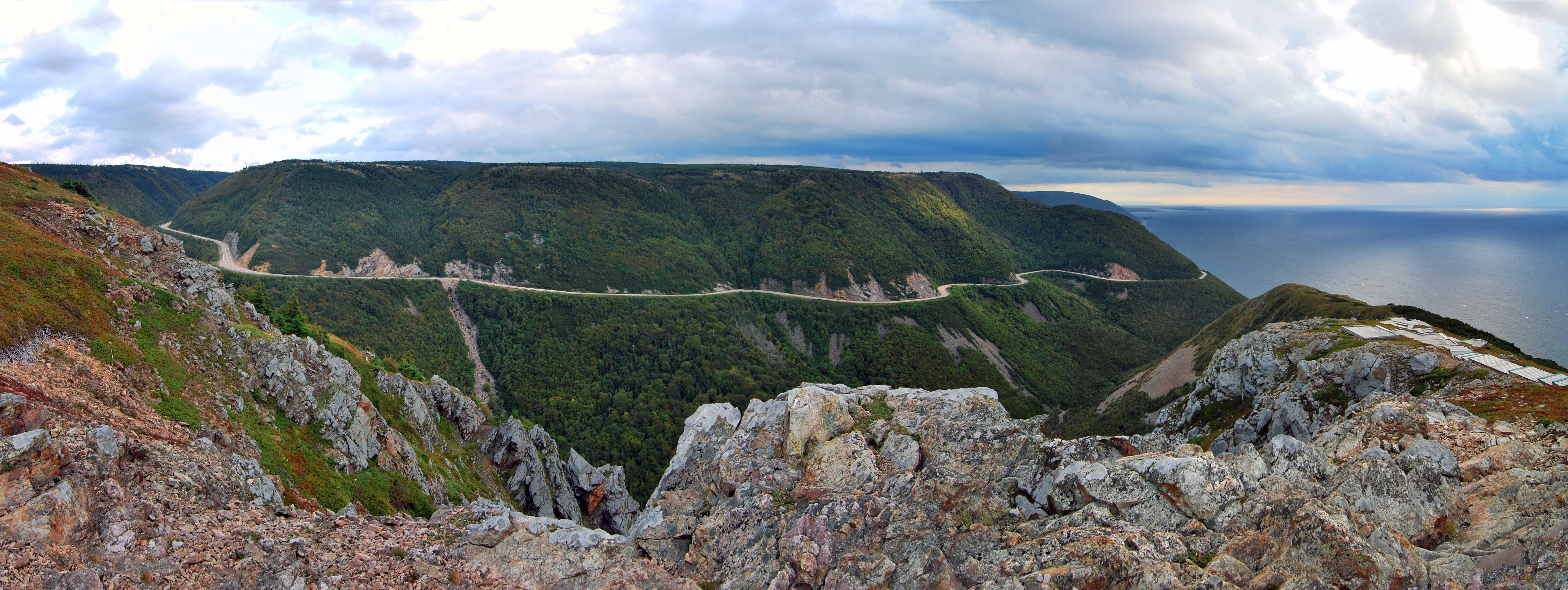
The Skyline and the Plateau
The Skyline Trail is the Cabot Trail's most famous stop, and for good reason. A boardwalk leads hikers to the edge of a headland that drops hundreds of meters to the Gulf of Saint Lawrence. Pilot whales surface in the waters below. Moose browse along the trail's margins, unfazed by visitors. The vantage point looks south along the coast, where the road ribbons between green ridgelines and blue water as far as the eye can follow. Above the Skyline, the Cape Breton Highlands plateau stretches inland, a tundra-like expanse of boreal forest and exposed rock that feels more like northern Labrador than Maritime Canada. The plateau holds Nova Scotia's highest point, White Hill, and supports an ecosystem where lynx, black bear, and snowshoe hare navigate terrain shaped by ice ages.
Villages Along the Loop
What makes the Cabot Trail more than a scenic drive is the human texture along its route. Cheticamp is the cultural heart of Cape Breton's Acadian community, where French is still the language of kitchens and wharves, and hooked rugs have been an art form for generations. Pleasant Bay, on the northwest coast, offers whale watching where humpbacks, minkes, and pilot whales feed in the nutrient-rich waters where the Gulf meets the open Atlantic. Cape North marks the trail's northernmost reach, a headland where the wind never fully relents. On the eastern descent, Ingonish anchors a stretch of beach and resort country, home to the Keltic Lodge and Highlands Links, an 18-hole golf course designed by Stanley Thompson that Golf Magazine once ranked among the world's top 100. Further south, St. Anns hosts the Gaelic College of Celtic Arts and Crafts, where Cape Breton's Scottish heritage is taught and celebrated.
A Road Built for Looking
Driving the Cabot Trail demands patience. The western and eastern sections hug coastlines where every switchback opens a new composition of rock, water, and sky. The road crosses the counties of Victoria and Inverness, two of Nova Scotia's least populated, and long stretches pass without a building in sight. Fog rolls in from the Gulf without warning, shrouding the cliffs in grey and making the occasional break of sunlight feel like a revelation. In autumn, the highlands erupt in color as sugar maples, birch, and tamarack turn shades of red, orange, and gold against the dark green of spruce. The loop takes most drivers a full day, though many spread it over two or three, stopping to hike, kayak, or simply sit on a headland and watch the weather change.
The Name That Stuck
Premier MacDonald's marketing gambit worked better than he could have imagined. The names he invented, Cape Breton Highlands and Cabot Trail, have become so synonymous with Nova Scotia tourism that most visitors assume they carry centuries of history. In truth, they date to the 1930s, when the province was looking for a way to attract Depression-era travelers. The road itself was a feat of engineering for its time, blasted through granite and laid across terrain that had previously been accessible only by boat or footpath. Nearly a century later, the Cabot Trail remains what MacDonald intended: a reason to come to Cape Breton. That the drive delivers far more than any tourism slogan could promise is the road's own doing.
From the Air
Located at 46.49°N, 60.75°W on the northern tip of Cape Breton Island, Nova Scotia. The 298 km loop is clearly visible from above, tracing the coastline around the Cape Breton Highlands. Best viewed from 3,000-8,000 ft AGL for full appreciation of the road's relationship to the cliffs and plateau. The nearest airports include Stephenville (CYJT) to the west across the Cabot Strait and Sydney/J.A. Douglas McCurdy Airport (CYQY) to the southeast. Look for the distinctive highland plateau dropping sharply to the Gulf of Saint Lawrence on the western side.