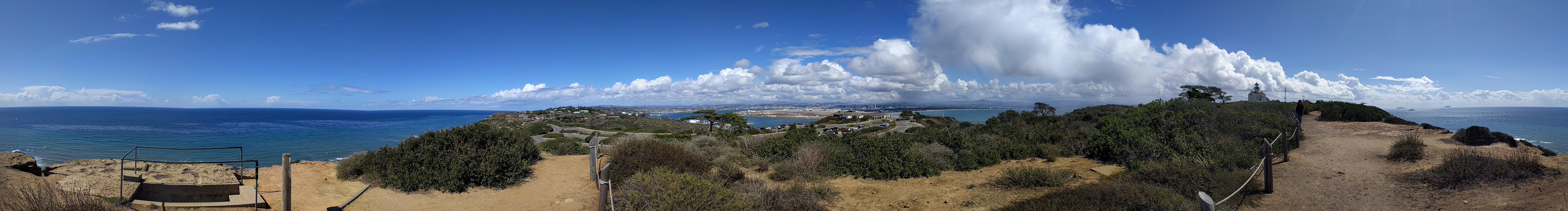
Cabrillo National Monument
On September 28, 1542, three small ships dropped anchor in a harbor the Kumeyaay people had known for millennia. Aboard the flagship San Salvador, a Portuguese navigator named Juan Rodriguez Cabrillo ordered his men ashore, becoming the first European to set foot on what would become the West Coast of the United States. He found a land of coastal sage scrub and rocky promontories, where gray whales migrated past in winter and tide pools teemed with life between the surges. Four hundred years later, that same windswept point at the tip of the Point Loma peninsula became Cabrillo National Monument, a sliver of wild California surrounded by one of America's largest naval complexes. From here, you can see Tijuana to the south, Coronado Island across the bay, and on clear days, the Pacific stretching unbroken to the horizon Cabrillo once sailed.
The Navigator's Gamble
Juan Rodriguez Cabrillo was not searching for San Diego Bay. He was looking for a passage to China, the fabled Strait of Anian that cartographers of his era drew with hopeful certainty on maps of lands they had never seen. What he found instead was a natural harbor so protected that it would later become home to the largest naval fleet on the Pacific coast. Cabrillo explored the bay, traded with the Kumeyaay, and claimed the land for Spain before sailing north along the California coast. He would die that winter from complications of a broken leg suffered on San Miguel Island, never knowing that his brief landing would be commemorated as the moment European and American histories converged on these shores.
A Light Too High
In 1851, surveyors from the U.S. Coastal Survey climbed to the crest of Point Loma and declared it the perfect location for a lighthouse. The logic seemed sound: at 422 feet above sea level, a light here could serve as both harbor beacon and coastal landmark, visible for 25 miles in clear weather. Construction began in 1854, and on November 15, 1855, the keeper climbed the winding stairs to light the oil lamp for the first time. For 36 years, the Old Point Loma Lighthouse welcomed sailors to San Diego harbor. But the surveyors had miscalculated. Fog and low clouds rolled in from the Pacific and wrapped around the clifftop, rendering the light invisible to the ships it was meant to guide. In 1891, the flame was permanently extinguished, replaced by a new lighthouse at the base of the cliff where the marine layer could not reach.
Between the Tides
The rocky shore below the monument holds one of the most diverse intertidal communities on the California coast. At low tide, visitors can explore pools crowded with purple sea urchins, orange bat stars, and the brilliant garibaldi fish that California named as its state marine fish. Hermit crabs scuttle between aggregating anemones while chitons grip the rocks with muscular feet. Coralline algae paints the stone pink and lavender. The Monument advises that the best viewing comes in late fall and winter, when negative tides expose the deepest pools during daylight hours. Above the tide line, the Bayside Trail winds through coastal sage scrub where Argentine ants have displaced native species, causing the coast horned lizard to vanish from areas it once inhabited.
The Whale Watch
In 1950, the National Park Service established the Whale Overlook at Cabrillo, creating the world's first public whale-watching station. Ten thousand people came that first year to scan the winter seas for the spouts and flukes of migrating gray whales. Each December through March, these 40-ton creatures pass Point Loma on their 12,000-mile journey from Alaskan feeding grounds to the breeding lagoons of Baja California. From the overlook, 100 yards south of the old lighthouse, visitors can watch them surface and blow, their breath hanging briefly in the salt air before the wind carries it away. The whales travel the same route Cabrillo sailed nearly 500 years ago, following a coastline that looks much as it did when his three ships first rounded the point.
What Remains
The monument that exists today is larger than what Woodrow Wilson first proclaimed in 1913, expanded by Eisenhower and Ford to encompass more than 160 acres. The old lighthouse stands restored, its tower open to visitors on two special days each year. Coastal artillery batteries from World War II dot the landscape, silent reminders of when the entire southern tip of Point Loma was closed to civilians and the guns faced seaward watching for enemy ships. A statue of Cabrillo gazes across the bay toward downtown San Diego and the naval air station on Coronado. Each fall, the Cabrillo Festival reenacts his landing at Ballast Point, complete with Kumeyaay, Portuguese, and Mexican performers celebrating the cultures that shaped this corner of California. The view from the monument encompasses everything Cabrillo could not have imagined: a city of millions, aircraft carriers at anchor, jets descending toward Lindbergh Field. Yet the tide pools still fill and drain with the moon, and the gray whales still pass, indifferent to the centuries.
From the Air
Cabrillo National Monument sits at the southern tip of Point Loma at coordinates 32.6731N, 117.2386W. Best viewed from 2,000-4,000 feet AGL approaching from the south or west. The Old Point Loma Lighthouse at 422 feet elevation is visible on the ridge. The monument is surrounded by Naval Base Point Loma and Fort Rosecrans National Cemetery. Nearest airports: San Diego International (KSAN, 5nm northeast), North Island NAS (KNZY, 3nm east), Brown Field (KSDM, 14nm southeast). Note: Restricted airspace R-2503 covers portions of Point Loma; verify NOTAMs before overflying the naval facilities.