Caguana Ceremonial Ball Courts Site
The stones have faces. Carved into the monoliths that line the ball courts at Caguana, petroglyphs stare out with expressions that have watched the mountain valley for more than seven centuries. A heron. A woman's form known as atabeyra. Moons, stars, planets. The Taino people who built these thirteen courts and plazas around 1270 AD were not simply playing games here -- they were marking the sky, aligning their architecture with astronomical events, and inscribing their understanding of the cosmos into rock hauled from the nearby Tanama River. This is the largest and most important pre-Columbian archaeological site in the West Indies, and it is alive with meaning that scholars are still working to decipher.
Courts Aligned with the Stars
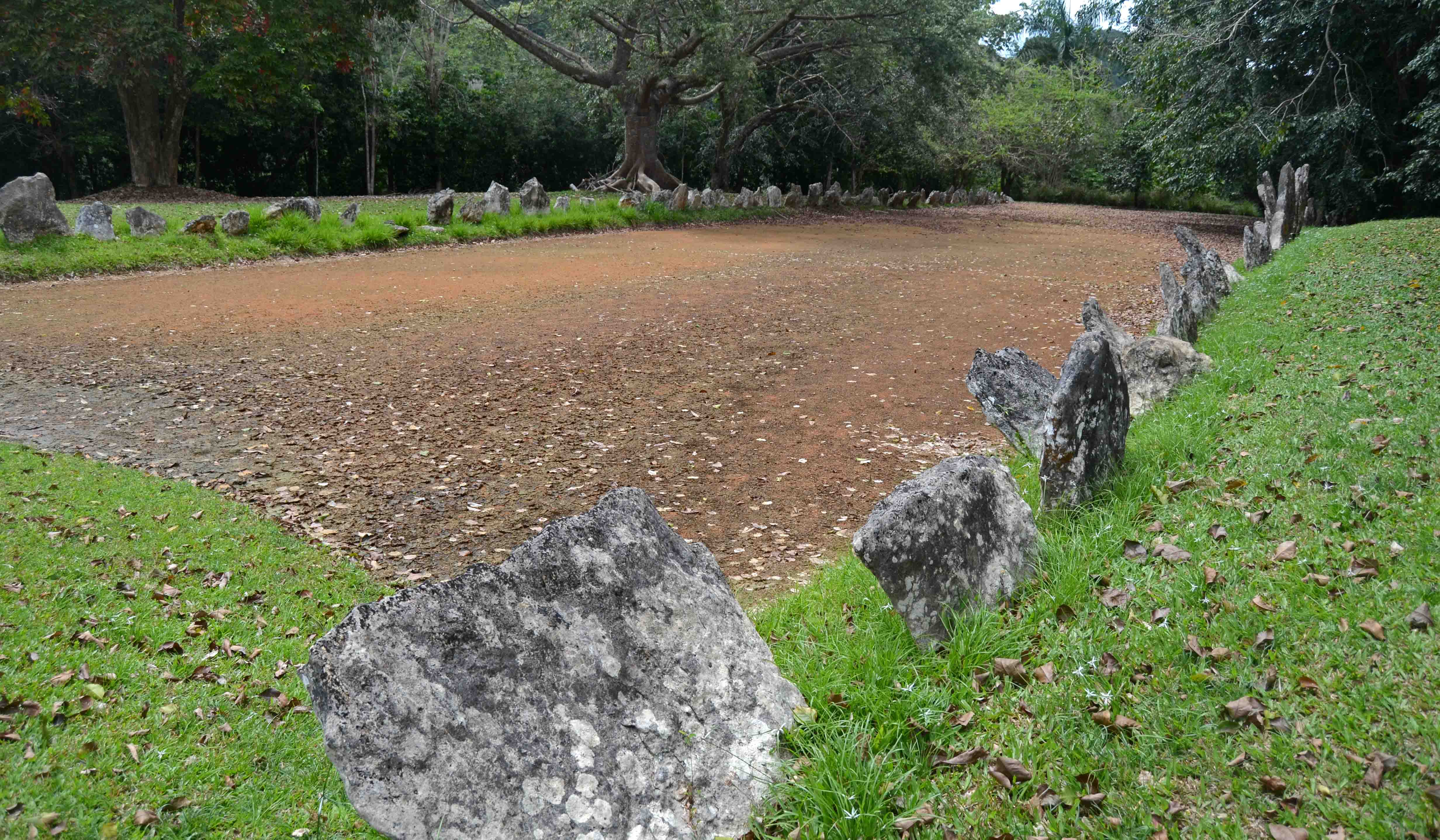
Approximately thirteen ball courts and plazas, called bateyes, have been identified at the Caguana site, many restored to their original configurations. The courts are bordered by stone monoliths -- some weighing more than a ton -- that were likely transported from the adjacent Tanama River. What makes Caguana exceptional is not just the number or preservation of its courts but their positioning. The layout of the site indicates deliberate alignment with specific astronomical events: planetary transits, stellar conjunctions, alignments of celestial bodies. Numerous petroglyphs depict the moon, stars, and planets, suggesting the site functioned as an observatory as well as a ceremonial and athletic ground. UNESCO's Astronomy and World Heritage Initiative has recognized these archaeoastronomical features, though the site has not been listed as a World Heritage Site.
Voices in Stone
The Caguana site holds the largest concentration of petroglyphs in the Antilles. These carvings are not decoration -- they are communication. Among the most famous is the figure called atabeyra, sometimes known as the "Caguana woman," and a heron-like bird whose form appears across multiple monoliths. The petroglyphs are carved into the same stones that form the boundaries of the bateyes, meaning the courts themselves are texts to be read as well as spaces to be used. Each monolith was placed with intention, its carved surface oriented to face specific directions. For the Taino, who did not use written language in the European sense, these stone inscriptions carried cultural knowledge across generations -- genealogies, cosmologies, astronomical observations encoded in images that their descendants can still interpret.
Rediscovery and Recognition
Local residents had long known the site as Corrales de los Indios -- "Indian corrals" -- named for the corral-like outlines of the stone-bordered courts visible on the surface. The first formal archaeological exploration was led by American anthropologist John Alden Mason in 1914, and continuous study has followed since the 1930s. Archaeologists from Yale University, including Irvin Rouse, conducted early excavations. Dr. Ricardo Alegria and the Institute of Puerto Rican Culture (ICP) later took stewardship, and the ICP acquired the site in 1965, investing in restoration and building an interpretive park and museum that opened the same year. The site was designated a National Historic Landmark and listed on the Puerto Rico Register of Historic Sites and Zones in 2001. In 2024, the museum reopened after a four-year closure with an expanded collection of more than 200 archaeological pieces, and a digital version -- the Museo Digital de Caguana -- launched the same year.
A Living Heritage
The park surrounding the archaeological site is itself a kind of museum. A botanical garden features the plants the Taino cultivated -- sweet potatoes, cassava, corn, yautia -- alongside the trees they used to build their homes: mahogany and ceiba, the great silk-cotton tree that holds deep spiritual significance in Taino culture. Reconstructed bohios, the traditional thatch-roofed houses, stand in the park as reminders that this was a lived landscape, not merely a ceremonial one. It matters to say this clearly: the Taino are not a vanished people. Their descendants live in Puerto Rico today, and Caguana is not a relic of a dead culture but a living connection to an identity that colonialism tried to erase and could not. The ball game itself, known as batey, carries forward in cultural memory -- a tradition older than European contact, still claimed and celebrated.
The Mountain View
Caguana sits in the Utuado municipality, deep in Puerto Rico's mountainous interior, along the banks of the Tanama River in a valley surrounded by steep green peaks. From the air, the courts are not easily distinguished from the surrounding landscape -- they are subtle, ground-level features built to human scale rather than monumental ambition. What the aerial view reveals instead is the terrain itself: why the Taino chose this place. The valley is sheltered, fertile, and watered by a reliable river. The surrounding mountains frame the sky in a way that makes astronomical observation intuitive. The site was not accidental. It was chosen with the same precision that went into the carving of every petroglyph and the placement of every stone.
From the Air
Located at 18.30°N, 66.78°W in the mountainous interior of Puerto Rico, in the Utuado municipality along the Tanama River valley. The site is at ground level and not easily visible from high altitude -- the ball courts and plazas are stone-bordered clearings in a river valley surrounded by mountains. Best appreciated from lower altitudes (2,000-3,000 feet) where the valley and river are discernible. Nearest significant airports: Rafael Hernandez Airport (TJBQ) in Aguadilla, approximately 25 miles northwest, and Luis Munoz Marin International (TJSJ) in San Juan, approximately 45 miles east. The terrain is mountainous cordillera -- maintain adequate altitude clearance. Weather: tropical mountain conditions with frequent cloud cover and afternoon rain showers.