Cahokia Mounds: North America's Forgotten Metropolis
In 1100 AD, Cahokia was the largest city north of Mexico. Its population approached 20,000 - bigger than London at the time, comparable to major European cities. The Mississippian people who built it constructed over 120 earthen mounds, including Monks Mound, the largest prehistoric structure in the Americas. They aligned their buildings with celestial events. They traded goods from the Gulf of Mexico to the Great Lakes. Then they vanished. By 1400, Cahokia was abandoned. When European settlers arrived in the 1800s, they found grass-covered hills they assumed were natural. The greatest city in pre-Columbian North America had been forgotten. We still don't know why it collapsed.
The City
Cahokia sat at the confluence of the Mississippi, Missouri, and Illinois Rivers - the heart of North America's waterway system. The location offered transportation, trade routes, and the rich agricultural land of the American Bottom floodplain. At its peak around 1100 AD, the city covered roughly six square miles. A wooden palisade surrounded the central precinct. Grand plazas hosted ceremonies. Neighborhoods of thatched houses spread in all directions. The population density exceeded most European cities of the era. This was genuine urbanism, complex society, centralized authority - everything European colonizers would later claim Indigenous peoples were incapable of creating.
The Mounds
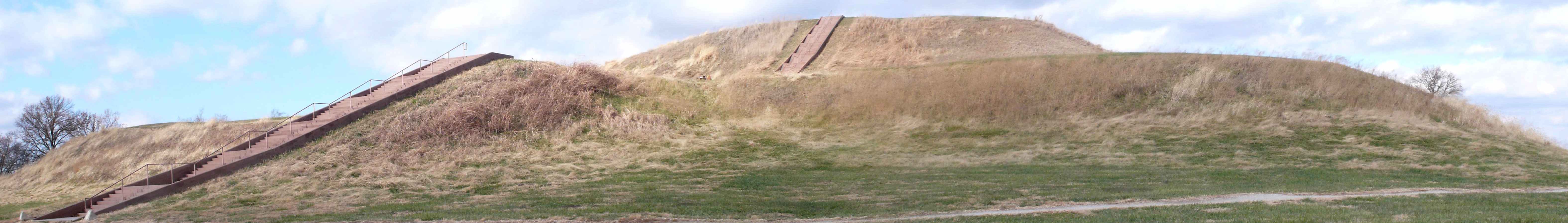
Cahokians moved approximately 55 million cubic feet of earth by hand - basket load by basket load - to construct their mounds. Monks Mound rises 100 feet, covering 14 acres, built in stages over centuries. Platform mounds supported buildings for elite residences and ceremonies. Conical mounds covered burials. Ridge-top mounds marked boundaries. The engineering is remarkable: Cahokians understood soil mechanics, drainage, and structural loading without written manuals or metal tools. Monks Mound has survived 900 years of erosion, testimony to its builders' competence. Over 120 mounds originally dotted the site; suburban St. Louis has destroyed most of them.
The Collapse
Cahokia began declining around 1200 AD and was abandoned by 1400. Nobody knows why. Theories include environmental degradation (deforestation, soil depletion), climate change (a prolonged drought), political instability, or epidemic disease. The population dispersed into smaller communities; no successor city arose. By the time Europeans arrived, Indigenous peoples in the region had oral traditions about the mounds but no direct connection to Cahokia's builders. The city's collapse illustrates the fragility of complex societies - Cahokia was North America's greatest urban achievement, and it lasted roughly three centuries before vanishing completely.
The Forgetting
European-American settlers didn't believe Indigenous peoples could have built the mounds. They invented 'Mound Builder' myths - attributing construction to lost tribes, Vikings, refugees from Atlantis, anyone but the ancestors of the people they were displacing. This willful ignorance served colonial purposes: if Indigenous peoples hadn't built anything permanent, they hadn't really occupied the land. Archaeological evidence eventually proved Native American construction, but the myth persisted. Cahokia's forgetting wasn't accidental; it was ideological, erasing Indigenous civilization to justify conquest.
Visiting Cahokia Mounds
Cahokia Mounds State Historic Site is located in Collinsville, Illinois, roughly 8 miles east of downtown St. Louis. The UNESCO World Heritage Site is open daily; admission is free, though donations support preservation. The Interpretive Center offers exhibits on Mississippian culture and the site's archaeology. Monks Mound is climbable via stairs; the view from the top surveys the entire site. Woodhenge, a reconstructed circle of wooden posts used for astronomical observations, demonstrates Cahokian solar alignments. Allow 2-3 hours for a thorough visit. St. Louis has extensive lodging and dining. Spring and fall offer comfortable temperatures for climbing the mounds.
From the Air
Located at 38.66°N, 90.06°W in the American Bottom floodplain of southwestern Illinois, immediately across the Mississippi from St. Louis. From altitude, Monks Mound is visible as a large rectangular earthwork rising above the flat terrain - clearly artificial, the largest prehistoric earthen structure in the Americas. The surrounding site preserves numerous smaller mounds, though suburban development has destroyed many. The St. Louis skyline, including the Gateway Arch, is visible across the river. The contrast is stark: the greatest city of pre-Columbian North America and the modern metropolis face each other across the Mississippi, separated by 900 years and almost complete cultural amnesia about what came before.