Cahokia: America's Forgotten First City
Before New York, before Boston, before any European set foot on North American soil, Cahokia thrived. In 1100 AD, this city on the Mississippi floodplain near present-day St. Louis housed 20,000 people - more than contemporary London. They built 120 earthen mounds, the largest covering 14 acres and rising 100 feet high. They established trade networks stretching from the Gulf Coast to the Great Lakes. They aligned their monuments with the stars. Then, around 1350, they vanished. When French explorers arrived centuries later, they found only silent mounds rising from the prairie. The people who built them were gone, their descendants scattered, their story lost. Cahokia is America's Pompeii - a great civilization that disappeared, leaving only earth shaped by human hands.
The Metropolis
At its peak around 1100 AD, Cahokia was the largest city north of Mexico. The population may have reached 20,000 in the central area, with thousands more in surrounding villages. The city covered six square miles, organized around a grand plaza larger than 40 football fields. The inhabitants - Mississippian culture ancestors of many modern tribes - built massive public works without metal tools, wheels, or draft animals. They moved millions of cubic feet of earth in baskets, one load at a time. The engineering was sophisticated: complex drainage systems, wooden palisades rebuilt multiple times, carefully oriented ceremonial structures. This was not a primitive village. This was a planned city.
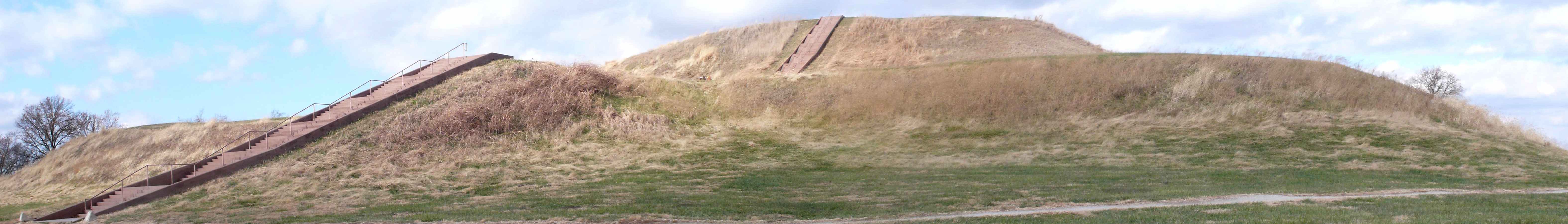
The Mounds
Monks Mound dominates the site - 100 feet tall, 14 acres at the base, the largest prehistoric earthwork in the Americas. Building it required moving 22 million cubic feet of earth over decades. The mound supported wooden structures on its terraced summit, likely residences for rulers or ceremonial buildings. Around it, 120 smaller mounds served various purposes: burial sites, platform mounds for buildings, marker mounds for celestial alignments. The mounds weren't random. They created a designed landscape, a statement of power and permanence that lasted 900 years after the people who built them disappeared.
The Mystery
Why did Cahokia collapse? By 1350, the city was essentially abandoned. Theories multiply: environmental degradation from deforestation, political instability, disease, warfare, climate change during the Little Ice Age. Archaeological evidence suggests all of these played roles. The palisade walls rebuilt multiple times hint at conflict. Declining nutrition in skeletal remains suggests resource stress. But no single catastrophe explains the abandonment. The Mississippians didn't die - their descendants became the historic tribes Europeans encountered. But they chose to leave their great city behind, dispersing into smaller communities that left less dramatic traces.
The Rediscovery
Early European settlers saw the mounds but couldn't believe Indigenous peoples had built them. They invented lost races, Welsh princes, wandering Israelites - anything except acknowledging Native American achievement. Scientific archaeology eventually established the truth: Cahokia was built by the ancestors of people still living when Europeans arrived. The site became a state historic site in 1925 and a UNESCO World Heritage Site in 1982. Today, Cahokia Mounds State Historic Site preserves 2,200 acres of the original urban area, including 80 surviving mounds. The interpretive center presents what archaeology has revealed - and acknowledges what remains unknown.
Visiting Cahokia
Cahokia Mounds State Historic Site is located in Collinsville, Illinois, 8 miles east of downtown St. Louis via Interstate 55/70. Admission is free; the interpretive center requests donations. Monks Mound is climbable via a modern stairway - 156 steps to the summit for panoramic views. The interpretive center includes a reconstructed village section, artifacts, and an award-winning orientation film. Walking trails connect major mounds. Woodhenge, a reconstructed solar calendar, offers sunrise alignments at equinoxes and solstices. Allow 2-4 hours for the interpretive center and mound exploration. The site rewards early morning visits when the mounds emerge from ground fog.
From the Air
Located at 38.66°N, 90.06°W on the Mississippi River floodplain near St. Louis. From altitude, Monks Mound is visible as a distinctive rectangular feature, much larger than surrounding terrain features. The mound complex occupies flat agricultural land, with the St. Louis metropolitan area visible to the west across the river. The Gateway Arch is approximately 8 miles west. The site's extent is difficult to appreciate from altitude - most mounds appear as subtle rises - but Monks Mound stands unmistakably, a human-made mountain on the floodplain that has dominated this landscape for 900 years.