Cahokia Woodhenge: America's Ancient Solar Observatory
A highway was about to pave over a thousand years of astronomical knowledge. In the early 1960s, archaeologist Warren Wittry was conducting routine salvage excavations ahead of interstate construction near Collinsville, Illinois, when he noticed something odd among the expected house foundations: unusually large post holes arranged in curving arcs. When he plotted them on a map, the arcs formed circles. Five of them, in fact, built one inside the other over two centuries, each larger and more elaborate than the last. Wittry realized he was looking at an American Stonehenge, a monumental timber calendar that the Mississippian people of Cahokia had used to track the sun across the sky.
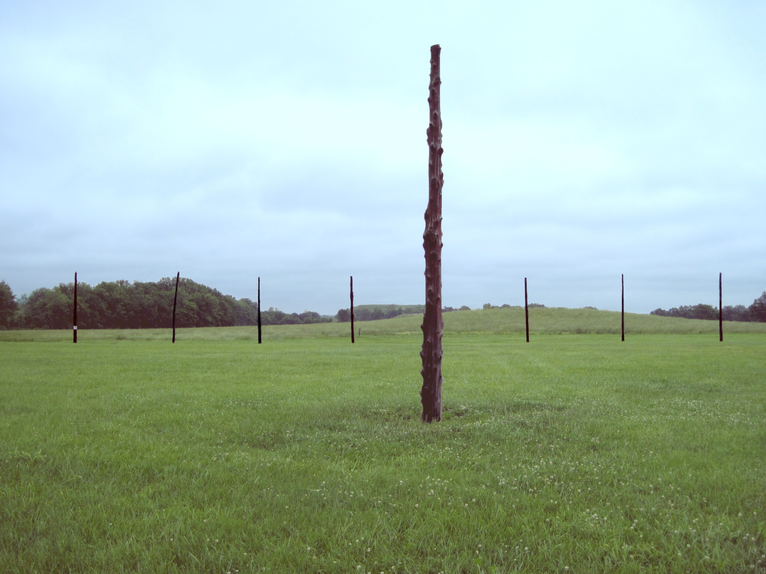
Circles in the Dirt
The five timber circles, designated Woodhenges I through V, were constructed between approximately 900 and 1100 CE, each iteration generally larger and containing twelve more posts than its predecessor. Woodhenge I, the earliest, had 24 posts. By Woodhenge III, the count had reached 48 posts, and the circle's diameter had grown substantially. Four of the five circles were built on the same spot, meaning each was dismantled before the next was erected, a pattern suggesting evolving astronomical understanding or changing ceremonial needs. Only Woodhenge I stood apart, built to the east of the others, and later deliberately dismantled when Mound 44 was constructed partially over its location.
Reading the Sunrise
From a central observation post within each circle, specific perimeter poles aligned with the sun's position on the horizon at the winter and summer solstices and the spring and fall equinoxes. The alignment was deliberate and precise. From the central pole of Woodhenge III, the sun appeared to rise directly from the top of Monks Mound at the winter solstice, a dramatic sight that would have been enhanced by the large temple structure that once stood at the mound's summit. This alignment between the solar calendar and the city's most important building was almost certainly by design, linking astronomical observation with political and spiritual authority. Ceremonial beakers found near the site depict the Woodhenge as a cross-in-circle motif with markers at the winter sunrise and sunset positions, confirming its sacred significance.
More Than a Calendar
The Woodhenges contained far more posts than needed to mark the four cardinal solar events. This surplus has led archaeoastronomers to speculate that the circles served additional purposes: tracking lunar cycles, monitoring the motion of the Pleiades star cluster, or observing other celestial bodies. Some researchers have proposed that the posts also helped align the construction of mounds and causeways throughout the greater Cahokia site, functioning as a kind of surveying tool for the city's ambitious building projects. The circles carried religious and ritual meaning beyond their practical function, reflected in their prominent placement west of Monks Mound and in the elaborate offerings found in pits near the solstice marker posts.
Salvaged from the Bulldozers
Wittry's discovery came just in time. The interstate highway construction that prompted the salvage excavation would have destroyed the post hole evidence entirely. Additional excavations by Robert L. Hall in 1963 confirmed the circles' existence, and Wittry returned in the late 1970s to complete the picture. In the 1980s, one of the circles was reconstructed at its original location using red cedar posts, giving visitors a tangible sense of the monument's scale. Today, the reconstructed Woodhenge hosts public sunrise observation events on mornings nearest the equinoxes and solstices, where an archaeologist explains the discovery and function of this ancient observatory. No rituals or ceremonies are performed, out of respect for American Indian beliefs.
Standing at the Center
To stand at the central observation post of the reconstructed Woodhenge on an equinox morning is to share an experience with people who lived a millennium ago. The sun rises behind a specific post, just as it did when Cahokia was the largest city on the continent. The timber circle sits on Collinsville Road, half a mile west of Monks Mound, in a flat expanse of the American Bottom floodplain. The setting is deceptively humble: a ring of wooden posts in an open field. But the precision of the alignments, the scale of the engineering, and the centuries of accumulated astronomical knowledge they represent make the Cahokia Woodhenge one of the most remarkable archaeoastronomical sites in North America, a place where ancient science and ceremony were inseparable.
From the Air
Located at 38.66N, 90.075W, roughly half a mile west of Monks Mound at the Cahokia Mounds State Historic Site near Collinsville, Illinois. From altitude, the reconstructed timber circle appears as a ring of posts in an open field within the larger 2,200-acre site. The nearest major airport is St. Louis Lambert International (KSTL), approximately 22 miles northwest. Interstate 55 runs nearby. The site sits in the Mississippi River floodplain known as the American Bottom. Best viewed at low altitude in clear weather.