Camas
The smell of pulp processing once defined Camas, the paper mill that gave the town its identity and economy filling the air with the distinctive scent of wood becoming paper. The Georgia-Pacific mill still operates on the Columbia's north bank, though cleaner technology has reduced what used to be an inescapable presence. Camas has evolved into something more than a mill town now - a bedroom community for Portland workers seeking Washington's lack of income tax, a gateway to the Columbia River Gorge, and a small city of 27,000 finding new identity as its industrial heritage recedes. The setting helps: the Columbia nearly a mile wide here, Mount Hood rising to the south, the Cascade foothills climbing to the north.
The Paper City
The Crown Willamette Paper Company established the mill that became Camas in 1883, drawn by the abundant timber and the Columbia's power potential. The mill grew through the twentieth century under various owners, becoming one of the largest paper producers on the West Coast. The town grew with it - worker housing climbing the hills, downtown serving the mill workers and their families, the economy rising and falling with paper prices.
Today the mill continues under Georgia-Pacific, though automation has reduced the workforce that once supported the town. Camas has diversified, its location on the eastern edge of the Portland metro making it attractive to commuters who work across the river but prefer Washington's tax structure. The transformation is visible downtown, where restaurants and shops have replaced some of the industrial-era businesses. But the mill remains, its smokestacks visible from everywhere in town, a reminder of what built this place.
Prune Hill
Much of residential Camas spreads across Prune Hill, an extinct volcanic vent that provides the elevated terrain where neighborhoods enjoy views of the Columbia and the Cascades. The hill is part of the Boring Lava Field, the volcanic province that dots northwest Oregon and southwest Washington with cinder cones and lava flows. The name comes not from boredom but from the town of Boring, Oregon, where geologists first studied the formation.
The views from Prune Hill take in Mount Hood across the river, the paper mill below, the Columbia stretching east toward the Gorge. Round Lake occupies a volcanic depression on the hill, providing a natural area surrounded by development. The terrain gives Camas its character - a town that climbs from industrial waterfront to hilltop residences, the layers of elevation reflecting the layers of the town's evolution from mill to suburb.
Gateway to the Gorge
Highway 14, the Lewis and Clark Highway, runs through Camas along the Columbia's north bank, continuing east into the Columbia River Gorge. This Washington-side route parallels the more famous Historic Columbia River Highway on the Oregon side, offering its own viewpoints and access to the dramatic scenery where the river cuts through the Cascades.
Cape Horn, a few miles east of town, provides one of the most dramatic viewpoints on either side of the Gorge. The overlook reveals the river curving through basalt cliffs, the walls of the Gorge rising steeply on both sides. In autumn the colors transform the scene; in spring waterfalls cascade from every cliff. Camas serves as a logical starting point for Gorge exploration, the last town of size before the highway enters the canyon proper.
Twin Cities
Camas and neighboring Washougal have grown together into a twin-city community, their borders blurring along the riverfront and in the subdivisions climbing into the hills. Washougal brings its own character - more outdoor-focused, known for the motocross events at Washougal MX Park and the river recreation along the Washougal River. Together the cities form an eastern anchor for Clark County, distinct from Vancouver's urban core while connected to the metropolitan economy.
The Columbia River defines both cities. Too wide for bridges here - the nearest crossings are at I-205 to the west and the Hood River Bridge far to the east - the river creates both barrier and attraction. Boat launches provide access; the waterfront offers views that include barges heading up and down the Columbia navigation channel. It's an industrial river here as much as a scenic one, the commerce and the beauty coexisting as they have since the first sawmills processed the timber that floated down from the mountains.
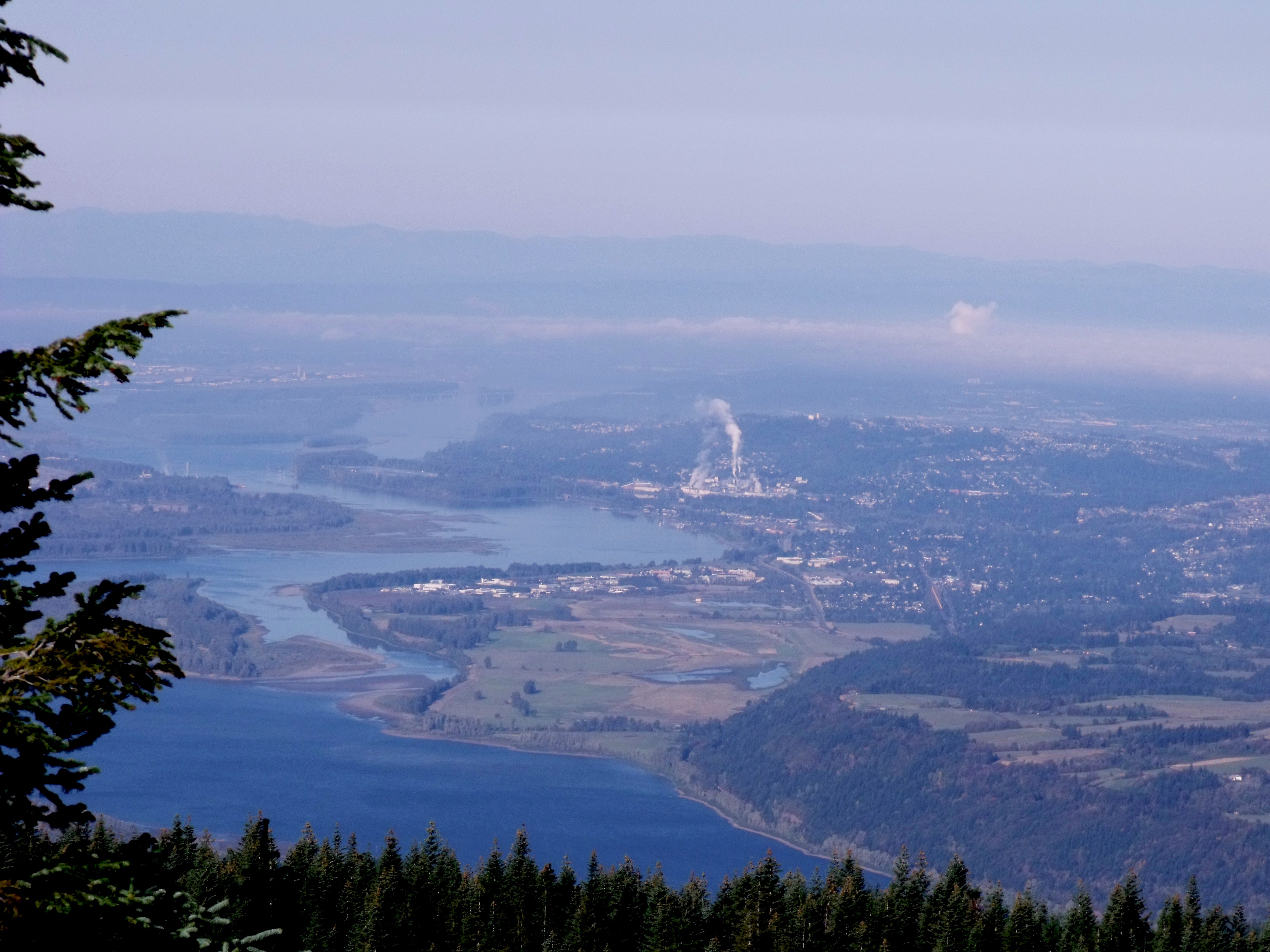
From the Air
Located at 45.59N, 122.41W on the north bank of the Columbia River in southwest Washington. The Georgia-Pacific paper mill is visible on the waterfront. Prune Hill rises behind the town, an extinct volcanic vent with residential development. The Columbia is nearly a mile wide here; the Glenn Jackson Bridge (I-205) is visible to the west in Vancouver. Highway 14 runs along the river through town, continuing east into the Columbia River Gorge. Mount Hood is visible to the south. Washougal is immediately east. Portland International Airport (KPDX) is approximately 15 miles west.