Canning Stock Route
Alfred Canning packed neck chains and handcuffs alongside his surveying equipment. Supplied by the Wiluna police, the restraints were not for criminals -- they were for the Aboriginal men Canning planned to capture and force to lead his party to water sources across some of the most unforgiving desert on Earth. The stock route he surveyed between 1906 and 1910, stretching 1,850 kilometres from Halls Creek in the Kimberley to Wiluna in the mid-west, would become the longest historic stock route in the world. Its construction required 51 wells sunk through desert that crosses the lands of nine different Aboriginal language groups. The water those wells tapped had sustained Indigenous life for 30,000 years.
The Beef Monopoly
At the turn of the twentieth century, east Kimberley cattlemen faced a problem that had nothing to do with the land. Their herds carried Boophilus ticks infected with babesiosis, a malaria-like parasitic disease, and were prohibited from being shipped south by sea for fear the ticks would spread. This gave west Kimberley cattlemen a monopoly on the beef trade to Perth and the goldfields, and prices climbed accordingly. East Kimberley pastoralists needed an overland route through the desert -- one long enough and hot enough that ticks could not survive the crossing. In 1905, a proposal for a stock route through the Great Sandy Desert, the Little Sandy Desert, and the Gibson Desert was put forward. Once the government confirmed that ticks would die during a desert crossing, the scheme won approval and funding. What sounded simple on paper -- a line of wells through the desert -- would require someone to find water in country that two previous expeditions had barely survived.
The Chains and the Wells
The Calvert Expedition of 1896, led by Lawrence Wells, had lost two members to thirst. David Carnegie's expedition later that year saw camels die from poisonous grass and a member accidentally shoot himself dead. Carnegie concluded the route was too barren to be practical. Both men had mistreated the Aboriginal people they encountered, tying them up and forcing them to find water. Carnegie is believed to have fed them salt to increase their thirst and compliance. Canning read both expedition accounts before setting out. He followed their example. During his survey from 1906 to 1910, Canning captured several Martu men, chained them by the neck, and forced them to reveal native water sources -- soaks that had sustained desert communities for millennia. A 1908 Royal Commission investigated his treatment of Aboriginal people, but Canning completed the route. Fifty-one wells were sunk along the 1,850-kilometre track.
Droving Through the Desert
The route fell into disuse almost immediately. By the time a 1928 Royal Commission into beef prices in Western Australia led to the wells being repaired and the route reopened, many had collapsed or been damaged. Around 20 cattle droves made the crossing between 1931 and 1959, when the final droving run was completed. Each drive was an extraordinary undertaking -- weeks of moving cattle through desert with no permanent water except the wells, relying on the skill of Aboriginal stockmen and women who knew the country in ways that European drovers never could. Successful droves depended on this Indigenous expertise, and Aboriginal workers were essential at every stage. Walkabout disease -- a condition affecting horses in the Kimberley -- was one of many hazards. The route crossed the territories of nine Aboriginal language groups, and the wells and stock movements inevitably disrupted traditional patterns of movement and connection to Country.
Out of the Desert
The stock route changed Aboriginal life along its length in ways that went far beyond the disruption of water sources. It became a path out of the desert. At different times and for different reasons, people moved to the outskirts of towns, to pastoral stations, and to church missions. Some sought more reliable food and water during drought. Others were drawn by the changes taking place around the desert's edges or wanted to join family members who had already left. Many found work with the droving parties. The Dreaming tracks that crisscross the Western Desert -- some contained within a single language group's Country, others spanning many -- often mark territorial boundaries, and the stock route cut across them all. Aboriginal communities have recorded this complex history through oral and artistic traditions. The Yiwarra Kuju exhibition, which opened at the National Museum of Australia and set attendance records, told the story of the stock route from an Indigenous perspective, drawing on a major art collection that the museum acquired in 2009.
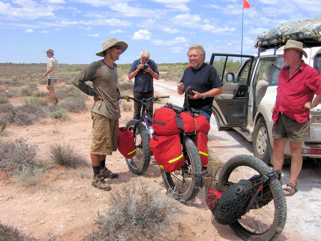
The Track Today
The Canning Stock Route is now considered one of the world's great four-wheel-drive adventures, though the word 'adventure' understates the commitment required. The track is not maintained beyond basic grading. Some wells have been restored; others are ruins. The 1,850-kilometre journey takes two to three weeks and demands a convoy of well-equipped vehicles, advance fuel drops, and careful timing for the cooler months. Two small settlements along the route -- Kunawarritji, roughly 1,000 kilometres north of Wiluna, and Billiluna, 173 kilometres south of Halls Creek -- offer fuel and limited supplies. A few travellers have crossed on foot, by bicycle, by motorcycle, and even in two-wheel-drive vehicles. The route was closed to tourists from March 2020 due to the COVID-19 pandemic and did not reopen until June 2022. For Aboriginal communities along its length, the stock route remains a contested line drawn through their Country -- a reminder of what was taken and, in the telling of its full story, what endures.
From the Air
Located at 18.32S, 127.55E (approximate midpoint near Well 33). The Canning Stock Route stretches 1,850 km from Halls Creek (YHLC) in the north to Wiluna in the south, crossing the Great Sandy Desert, Little Sandy Desert, and Gibson Desert. From altitude, the track appears as a faint line through vast red desert, with occasional cleared patches at well sites. The route is best appreciated from 15,000-25,000 ft where its extraordinary length through featureless desert becomes apparent. Nearest airports: Halls Creek (YHLC) at the northern end, Wiluna (not ICAO-listed) at the southern end.