Canyon de Chelly National Monument
Canyon de Chelly holds more continuous human history than almost anywhere in North America. For five thousand years, people have lived in this dramatic gorge in northeastern Arizona, leaving behind traces at every level: petroglyphs from prehistoric hunters, the elegant cliff dwellings of the Ancestral Puebloans who built here between 1100 and 1300 CE, the hogans and farms of the Navajo who arrived in the 1700s and never left. The canyon also witnessed one of American history's darkest chapters: in 1864, Kit Carson led U.S. troops through these narrows, burning crops and orchards, forcing the Navajo on the brutal Long Walk to captivity at Fort Sumner. Today the canyon remains Navajo land - the only National Park Service unit entirely on tribal trust territory - and Navajo families still farm and graze sheep on the canyon floor. This is not a preserved ruin but a living landscape, where ancient petroglyphs share space with pickup trucks and the descendants of those who survived the Long Walk maintain homes their ancestors defended with their lives.
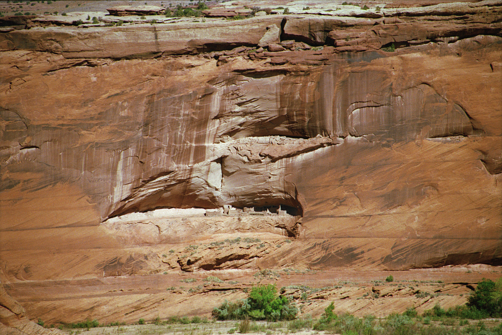
Ancient Inhabitants
The canyon's human story begins around 2500 BCE with archaic hunters who sheltered in its alcoves, leaving behind pictographs that predated the pyramids. The Basketmaker peoples followed, developing agriculture and settling more permanently in pit houses. By 1100 CE, the Ancestral Puebloans - once called Anasazi, though the Navajo consider that term disrespectful - had constructed the multistory cliff dwellings that still cling to ledges high above the canyon floor. White House Ruin, the most famous, rises four stories within an alcove that sheltered it from weather for nine centuries. The pueblo peoples departed around 1300 CE, likely driven by drought, their descendants probably among today's Hopi and Zuni. But they left their architecture behind, and the canyon walls bear their petroglyphs of spirals, bighorn sheep, and humanoid figures that scholars still debate.
The Long Walk
The Navajo arrived in Canyon de Chelly in the 1700s, establishing farms and orchards along the permanent water that flows through its narrows. For a century, they prospered here, using the canyon's defensible terrain to resist Spanish and later American incursions. But in 1863, the U.S. Army ordered the Navajo removed from their homeland. Kit Carson led a campaign of destruction: burning crops, killing livestock, cutting down the famous peach orchards that fed the community. Starving and desperate, most Navajo surrendered. In March 1864, over eight thousand began the Long Walk - a three-hundred-mile forced march to Bosque Redondo at Fort Sumner, New Mexico. Hundreds died along the way; hundreds more perished in the wretched conditions at their destination. After four years, the survivors were permitted to return. They rebuilt, replanted, and never forgot.
Three Canyons
The national monument encompasses three canyons: Canyon de Chelly proper (pronounced 'duh-SHAY,' from the Navajo Tséyi', meaning 'rock canyon'), Canyon del Muerto ('Canyon of the Dead,' named for ancient burials discovered there), and Monument Canyon, which joins them. The canyon system runs roughly 26 miles long, with walls that start modestly at the western entrance near Chinle and rise to over a thousand feet at the eastern reaches. Spider Rock, an 800-foot sandstone spire, stands where Monument Canyon meets Canyon de Chelly - in Navajo tradition, home to Spider Woman, who taught the people to weave. The canyon floor supports cottonwood groves, willows, and the irrigated fields where Navajo families grow corn, melons, and other crops using water rights that predate American occupation.
Living Canyon
Unlike most national monuments, Canyon de Chelly remains private land - Navajo Tribal Trust territory administered jointly by the tribe and the National Park Service. Several dozen Navajo families maintain summer residences on the canyon floor, farming and herding as their ancestors did. Their presence distinguishes this place from archaeological sites frozen in time; here, the past coexists with the present. Visitors see not just ancient ruins but modern hogans, not just petroglyphs but sheep grazing beneath them. This arrangement requires respect: the canyon floor cannot be visited without Navajo guides except via the White House Ruins Trail. Photography of residents requires permission. The canyon is home, not exhibit, and its people determine the terms of access.
Visiting the Monument
The monument offers two rim drives with spectacular overlooks: the South Rim Drive passes Spider Rock and several viewpoints over Canyon de Chelly, while the North Rim Drive follows Canyon del Muerto past Mummy Cave and Massacre Cave overlooks. Both drives are free and require no guides. To enter the canyon floor, visitors must hire authorized Navajo guides for hiking or four-wheel-drive tours - a regulation that both protects the land and supports the local economy. The exception is the White House Ruins Trail, a 2.5-mile round-trip hike descending 600 feet to one of the best-preserved pueblo ruins, accessible independently when seasonally open. The nearest town, Chinle, offers basic services. Remember: this is Navajo land, and alcohol is prohibited throughout the reservation.
From the Air
Located at 36.16°N, 109.51°W in northeastern Arizona within the Navajo Nation. The canyon system appears from altitude as a dramatic gorge cutting through the red sandstone plateau. Spider Rock is visible as a distinctive 800-foot spire at the junction of canyons. The town of Chinle sits at the western entrance. Albuquerque International Sunport (ABQ) is 190 miles east; Flagstaff Pulliam Airport (FLG) is 180 miles west. Monument Valley lies 90 miles north.