Canyon Sainte-Anne
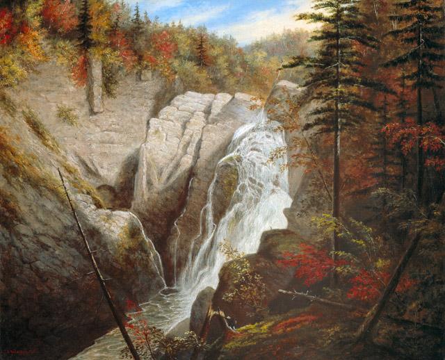
Henry David Thoreau came here in 1850, seeking wildness, and found it in the roar of water plunging through rock older than complex life itself. The Sainte-Anne-du-Nord River had been doing its patient work for millennia, carving a steep-sided gorge through granitic gneiss that formed 1.2 billion years ago in the Precambrian depths of the Canadian Shield. Today, three suspension bridges arc across that gorge, the highest swaying dizzyingly above the river, and visitors peer down at the same scene that stopped Thoreau mid-stride and moved the painter Cornelius Krieghoff to capture it on canvas. Canyon Sainte-Anne sits just 25 to 30 minutes east of Quebec City, but it feels like a crack in time itself.
Rock That Remembers the Precambrian
The geology of Canyon Sainte-Anne reads like a compressed history of the continent. The canyon walls are granitic gneiss, metamorphic rock forged under immense heat and pressure 1.2 billion years ago, then thrust upward through erosional uplift to become the bones of the Canadian Shield. This is the same ancient formation that stretches across northern Manitoba, Ontario, and Quebec, encircling Hudson Bay. Atop the gneiss sits a layer of slate, metamorphosed from marine mud that settled in shallow Paleozoic seas some 450 million years ago, then hardened during the Acadian orogeny. Two ice ages completed the sculpting. The glaciers advanced and retreated, their colossal weight depressing the Earth's crust so deeply that when the ice melted, Atlantic waters flooded inland to form the Champlain Sea. The rebound of the crust and the relentless erosion of the Sainte-Anne-du-Nord River produced the landscape visitors walk through today: a gorge where you can touch rock that predates every living thing.
A Logger's Secret
The canyon hid in plain sight for decades. Loggers had used the Sainte-Anne-du-Nord River as a highway at the start of the 20th century, floating timber downstream, but the gorge itself remained known only to those who worked the woods. In the summer of 1965, Jean-Marie McNicoll was on a camping trip when a retired logger described a route to a waterfall on the Sainte-Anne River. There was no road. Jean-Marie bushwhacked through dense forest and emerged at the canyon rim, stunned by what he found. He hurried back to tell his brother Laurent that he had discovered something extraordinary. Two years later, the McNicoll brothers leased the riverbanks from Hydro-Quebec and purchased the wooded lots connecting Route 138 to their prize. They cleared a road by hand, built paths to the rim, and on July 14, 1973, welcomed their first visitors to a gorge that had been waiting millions of years for an audience.
Bridges, Iron Rungs, and Giant Potholes
Three suspension footbridges now span the canyon at various heights, each offering a different perspective on the waterfall below. The highest perches far above the river, swaying gently in the updrafts that carry mist from the cascade. From these bridges and the many scenic overlooks along the rim, visitors discover giant potholes ground into the rock by millennia of swirling water and stone. Rock climbing routes ascend the canyon walls under supervision. A via ferrata, the first installed anywhere in Canada, lets climbers traverse the rock face on iron rungs and steel cables, suspended above the gorge with the roar of the falls as a constant companion. Rappelling routes drop directly down the cliff faces. For those who prefer to keep their feet on solid ground, the overlooks reveal cascade after cascade as the river drops through the narrowing gorge. The canyon draws over 100,000 visitors per year, open from May through October, each season painting the rock walls in different light.
Where the Beaupre Coast Meets Charlevoix
Canyon Sainte-Anne sits at a geographic crossroads, straddling the border between the municipalities of Saint-Ferreol-les-Neiges and Saint-Joachim, where the Beaupre Coast gives way to the Charlevoix region. The surrounding landscape is dense with destinations that draw millions: the Basilica of Sainte-Anne-de-Beaupre, one of the oldest pilgrimage sites in North America; the ski runs of Mont Sainte-Anne; the thundering Montmorency Falls, which drop higher than Niagara; and the Cap Tourmente National Wildlife Area, where hundreds of thousands of greater snow geese gather each autumn. The canyon anchors a stretch of Quebec that concentrates natural drama into a remarkably small area. Krieghoff painted the falls here in 1855. Thoreau described them in his journals. In 2000, the gorge even served as a filming location for the movie Battlefield Earth. From the sacred to the cinematic, Canyon Sainte-Anne keeps drawing people to its rim to stare into the chasm and feel the spray on their faces.
From the Air
Canyon Sainte-Anne is located at 47.073N, 70.877W, approximately 40 km northeast of Quebec City along the Beaupre Coast. The gorge of the Sainte-Anne-du-Nord River is narrow and may be difficult to spot from high altitude, but the surrounding terrain shows the river valley cutting through forested hills of the Canadian Shield. Quebec City Jean Lesage International Airport (CYQB) is the nearest major airport, about 35 km to the southwest. The nearby Mont Sainte-Anne ski area provides a prominent visual landmark with its cleared ski runs visible on the mountainside. Montmorency Falls, another major landmark, lies about 20 km to the west along the St. Lawrence River shoreline. Best viewed at lower altitudes (2,000-4,000 ft) where the river gorge becomes visible cutting through the forest canopy. The area is scenic year-round but particularly striking in autumn when foliage colors contrast with the dark rock walls.