Cape Hatteras Lighthouse
Approximately 1,250,000 bricks, stacked 198 feet into the salt air, wrapped in black and white spiral stripes that sailors have recognized for more than 150 years. Cape Hatteras Lighthouse is not just the tallest brick lighthouse in the United States. It is a stubborn act of engineering defiance against the most treacherous stretch of water on the Atlantic coast, a place where the warm Gulf Stream rams headlong into the frigid Labrador Current, throwing up storms that have shattered hulls and scattered cargo across the shifting Diamond Shoals for centuries. The waters earned the name the Graveyard of the Atlantic, and the lighthouse was built to stop the killing.
Hamilton's Light
The story begins with Alexander Hamilton. In 1794, the Secretary of the Treasury pushed Congress to fund a lighthouse at Cape Hatteras after his own ship nearly wrecked on the approach to the coast, a brush with disaster that earned the future tower the nickname "Hamilton's light." Congress appropriated $44,000, and by 1802 the first Cape Hatteras Lighthouse stood on the headland, a dark sandstone tower with 18 oil lamps and reflectors. It was adequate for the era but frustrating for mariners. Lieutenant David D. Porter of the U.S. Navy inspected it in 1851 and delivered a withering assessment. Over the following years the light was steadily improved, with larger reflectors in 1845, upgraded lamps in 1848, and finally a powerful first-order Fresnel lens in 1854. Then the Civil War intervened. Confederate forces destroyed the lens and lantern, though the Union managed to re-exhibit the light by 1862.
A Tower Built to Last
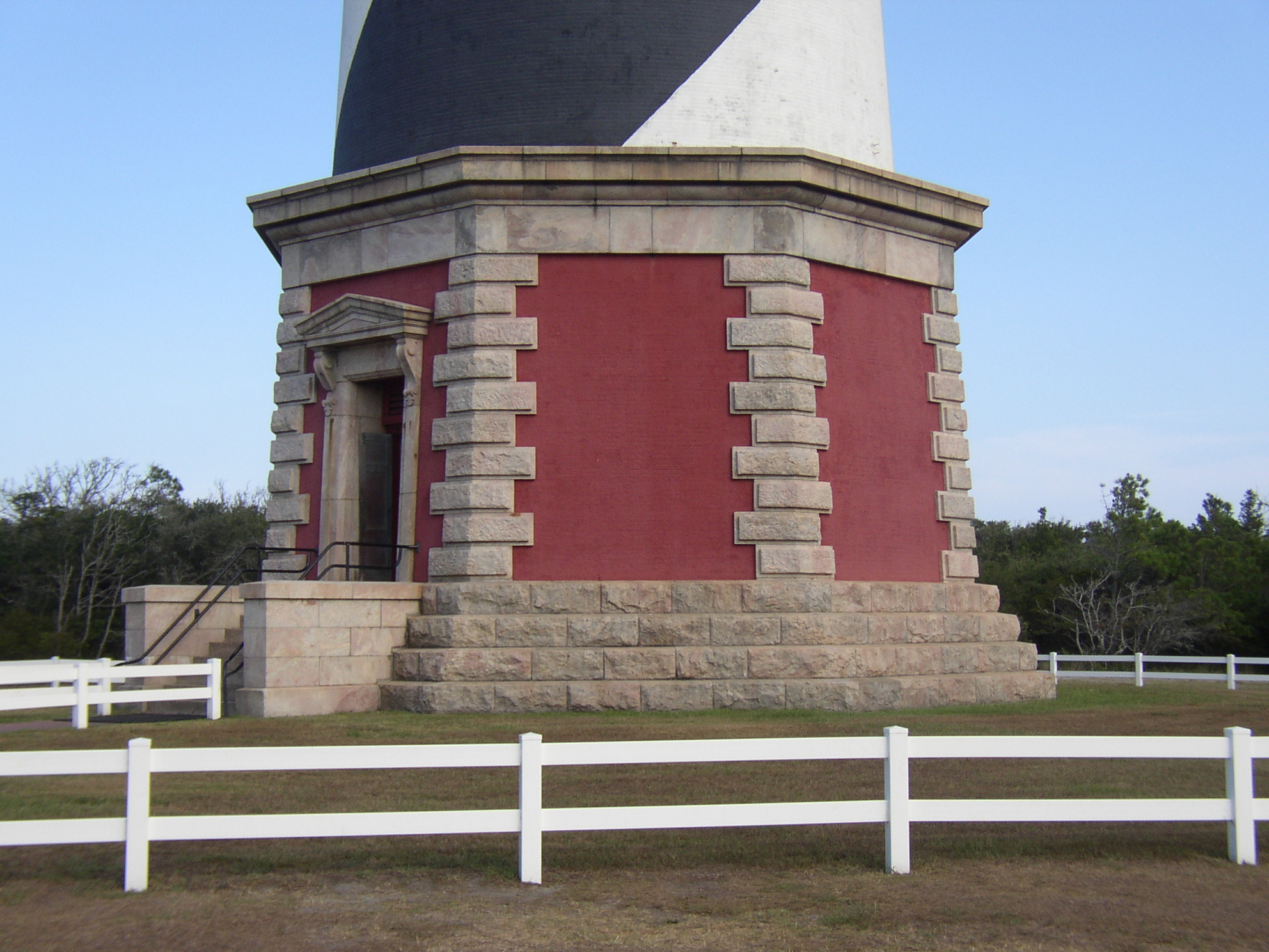
After the war, mariners and Navy officers lobbied for a completely new beacon. Congress appropriated $80,000 in 1868, and under the direction of Brigadier General J. H. Simpson of the Army Corps of Engineers, a new tower rose in just under two years at a final cost of $167,000. The first-order light was exhibited on December 16, 1871. The new tower was the tallest brick lighthouse in the world, and its distinctive black double-helix spiral painted against a white background gave it a daymark that no sailor could mistake. Each North Carolina lighthouse carried its own pattern so that captains could identify which light they were approaching during daylight hours. At Cape Hatteras, the spiraling stripes became iconic. The old sandstone tower was demolished in February 1871, and its ruins lingered on the beach until a storm finally swept them away in 1980.
The Ocean Fights Back
From the moment the new tower was completed, the sea began creeping toward it. The encroachment was gradual at first, almost imperceptible. By 1919 the high-water line had advanced to within 120 feet of the base. By 1935 the surf was lapping at the foundation itself. Dikes and breakwaters failed to hold it back. That year the Coast Guard gave up and deactivated the brick tower, replacing it with an aviation-style beacon mounted on a steel skeleton tower set further inland on a sand dune. The abandoned lighthouse was handed to the National Park Service. Then nature reversed course. The Civilian Conservation Corps and Works Progress Administration erected wooden revetments that slowed the erosion, and sand began accreting on the beach. By the mid-1940s, the tower stood 500 feet or more from the waterline. During World War II, with German U-boats sinking ships just offshore, the Coast Guard reclaimed the tower as a lookout station. By 1950, with the beach stable enough, the light was recommissioned with a 250,000-candlepower rotating beacon.
The Move of the Millennium
Erosion returned. By the 1990s the Atlantic was threatening the lighthouse once more, and the National Park Service faced a stark choice: lose the tower or move it. In 1999, the engineering firm International Chimney and Expert House Movers did what many thought impossible. They lifted 5,000 tons of brick and iron, 200 feet of tower, and moved the entire structure 2,900 feet inland to safety. The project, dubbed "The Move of the Millennium," earned the 40th Annual Outstanding Civil Engineering Achievement Award from the American Society of Civil Engineers. Cape Hatteras Lighthouse became one of the tallest masonry structures ever relocated. Today, the light still flashes from behind its two 1,000-watt lamps, producing 800,000 candlepower, visible for 20 nautical miles in clear conditions and reportedly spotted from as far as 51 miles out in exceptional weather. Visitors climb 257 steps through the interior spiral staircase to reach the lantern room, where the view stretches across the barrier islands to the open Atlantic.
Sentinel of the Shoals
The lighthouse stands within the Cape Hatteras National Seashore, flanked by the Hatteras Island Visitor Center and Museum of the Sea in the historic Double Keepers' Quarters. The museum documents the maritime heritage of the Outer Banks, the wrecks that gave Diamond Shoals its fearsome reputation, and the keepers who tended the light through hurricanes, wars, and the slow assault of the ocean itself. The black-and-white spiral remains one of the most recognizable silhouettes on the American coastline. It shares its diagonal daymark style with the St. Augustine Light in Florida, though each tower's pattern is unique. The lighthouse is not just a navigational aid. It is a monument to the persistence of the people who built it, rebuilt it, moved it, and refused to let the Atlantic swallow it whole.
From the Air
Located at 35.25N, 75.53W on Hatteras Island in the Outer Banks of North Carolina. The distinctive black-and-white spiral tower is clearly visible from the air, standing 198 feet tall near the village of Buxton. Best viewed at 1,500-3,000 feet AGL. Diamond Shoals extend southeast from the cape and are visible as discolored water in calm conditions. Nearest airport: Billy Mitchell Airport (KHSE), approximately 3 nm southwest. The Gulf Stream is often visible as a color change in the ocean to the southeast.