Cape Kiwanda State Natural Area
Most capes along the Oregon Coast are basalt - dark, dense volcanic rock that shrugs off the Pacific for millennia. Cape Kiwanda is sandstone. That difference explains everything about the place: the honeycomb textures, the natural arches, the deep chasms where waves boom and echo, the tide pools carved into surfaces soft enough to sculpt but hard enough to hold their shape for a human lifetime. Located in Pacific City on Tillamook County's Three Capes Scenic Route, Kiwanda is a headland that shouldn't still exist, and the story of why it does involves a basalt bodyguard, a Miocene-era sea stack, and the slow retreat of stone before water.
The Bodyguard and the Retreat
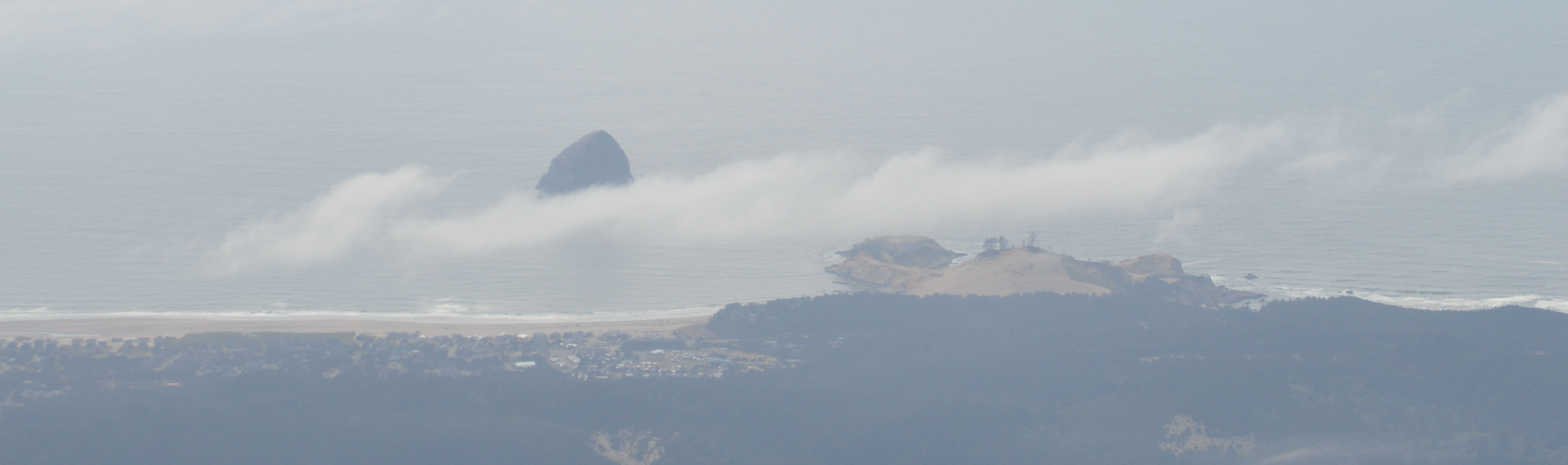
Chief Kiwanda Rock, the basalt sea stack standing offshore to the southwest, once connected directly to the cape. The promontory originally extended out to meet it - sandstone bonded to an intrusive basalt core, the harder rock shielding the softer from the worst of winter's southwest storms. Then erosion found the flanks. Water separated basalt from sandstone, isolating Chief Kiwanda Rock as a sea stack and leaving the cape exposed. Without its shield, the sandstone tip retreated to its current position, wave by wave, storm by storm.
But the bodyguard hasn't entirely abandoned its post. Chief Kiwanda Rock still absorbs some of the impact from southwest swells, breaking the largest waves before they reach the cape. It's a partial defense, diminishing with every century as both formations erode. The cape is retreating - waves undercut the sea cliffs from below while rockfall crumbles them from above - but the retreat is slow enough that generations of visitors have known Kiwanda as a place of permanence rather than loss.
Sandstone Gallery
Walk the cape at low tide and you enter a gallery of erosional art. The sandstone belongs to the Astoria Formation, and the Pacific has been working it like a sculptor for thousands of years. Tide pools pocket the surfaces, each one a miniature ecosystem of anemones and sea stars. Natural arches frame glimpses of ocean through stone. Deep chasms channel incoming surges into throaty explosions of spray. Small inlets form sheltered pools where the water turns impossibly clear.
Above the wave-carved lower reaches, remnants of enormous Holocene-era parabolic dunes blanket the highest elevations of the cape, adding sweeping sand formations to an already varied landscape. The combination - wave-carved stone below, wind-sculpted dunes above, all of it bathed in the shifting light of the Oregon Coast - makes Kiwanda one of the most photogenic landforms in the Pacific Northwest. Photographers return across seasons, chasing the way fog softens the textures or sunset gilds the sandstone gold.
Three Haystacks and a Lost Duckbill
Chief Kiwanda Rock is one of three features along the Oregon Coast that carry the name "Haystack Rock." The most famous stands at Cannon Beach, a postcard icon recognized worldwide. The one near Cape Kiwanda is less celebrated but no less striking - a dark basalt tower rising from the surf, its surface colonized by seabirds, its silhouette unmistakable against Pacific sunsets. The name repetition speaks to how common the formation is along this coast, where volcanic intrusions resist the waves that dissolve everything softer around them.
Not every formation survives. The Duckbill, a distinctive sandstone pillar shaped like its namesake, stood as one of the cape's beloved attractions until August 2016, when vandals deliberately toppled it. The loss was a reminder that sandstone formations exist on borrowed time even without human interference - but that humans can accelerate the clock in a single reckless act. What nature would have taken decades or centuries to accomplish, vandalism completed in moments.
The View from the Top
Hiking to the summit of Cape Kiwanda rewards with a panorama that stretches the length of the Three Capes Scenic Route. To the south, Nestucca Bay spreads its tidal flats into the coastal lowlands, its waters shifting between silver and brown with the tides. To the north, Cape Lookout extends its sharp promontory into the Pacific, a basalt finger pointing west that makes Kiwanda's sandstone seem even more improbable by comparison. On clear days the coastline unfolds in both directions - headland after headland stepping into the haze, each one marking where resistant rock meets relentless ocean.
Below the summit, Pacific City's dory fleet launches directly from the beach, flat-bottomed boats running through the surf in a tradition that dates back decades. The boats return the same way, riding waves onto sand with practiced timing. It's a working beach, not just a scenic one - fishing boats alongside surfers alongside hikers alongside photographers, all drawn to a sandstone cape that geology says shouldn't be here and the ocean is slowly proving right.
From the Air
Located at 45.22°N, 123.97°W on the northern Oregon Coast. The cape is a distinctive tan-colored sandstone promontory jutting into the Pacific, easily distinguishable from the darker basalt headlands to the north and south. Chief Kiwanda Rock (the basalt sea stack) is visible just offshore to the southwest. Look for Pacific City's beach to the east and Nestucca Bay to the south. Cape Lookout is visible approximately 8 miles to the north as a long narrow promontory. Nearest airport is Tillamook (KTMK), about 20 nautical miles to the northeast. Portland International (KPDX) is approximately 75 nautical miles to the east. Best viewed at 2,000-3,000 feet AGL for the full coastal panorama. Coastal fog is common, especially in summer mornings; afternoon clearing typical.