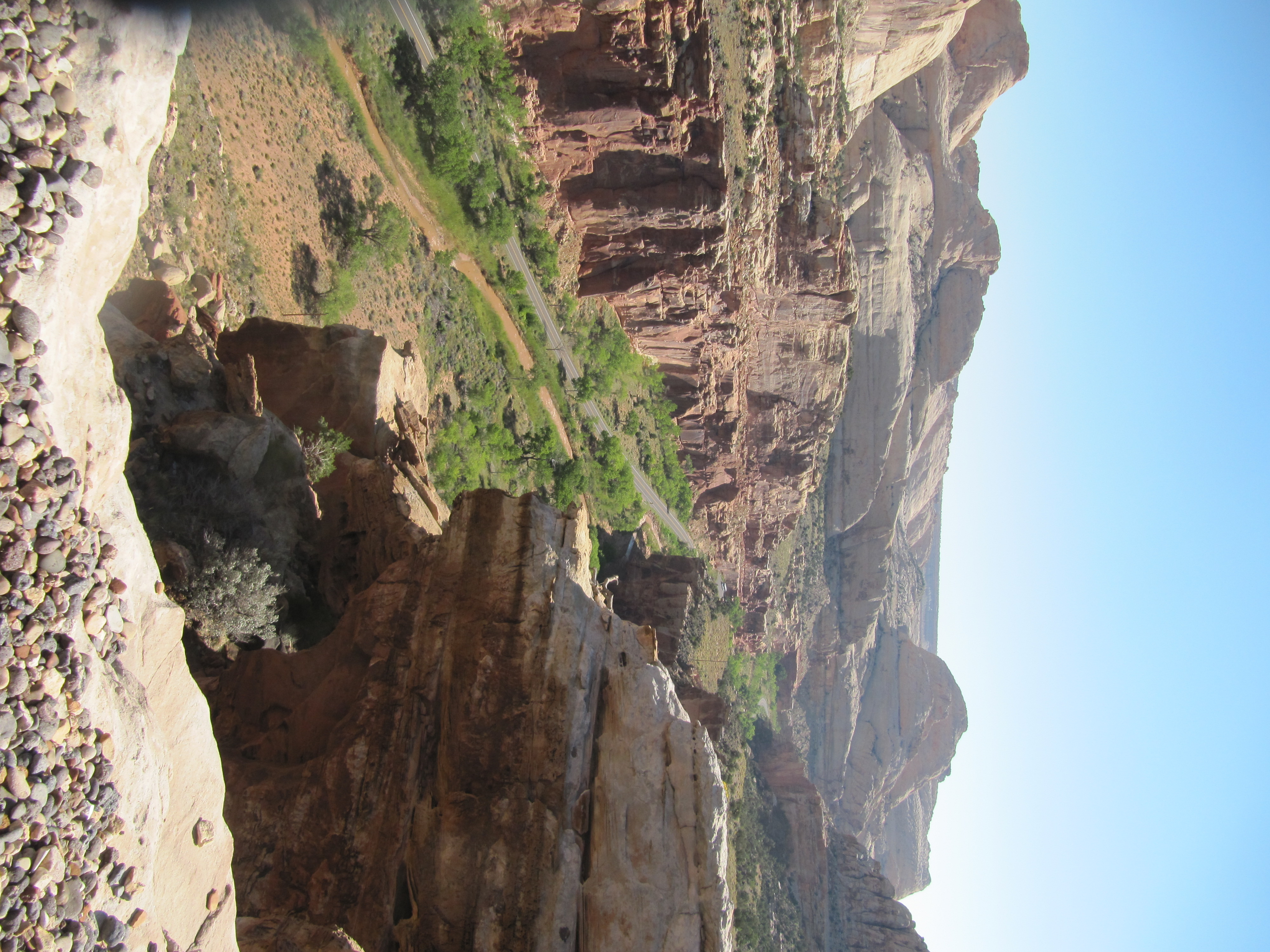
Capitol Reef National Park
The name makes no sense until you stand here. 'Capitol' comes from the gleaming white domes of Navajo Sandstone that line the Waterpocket Fold, each one vaguely resembling the dome of the United States Capitol building. 'Reef' is an old settler's term for any rocky ridge impassable to wagons, a barrier on land the way coral reefs are barriers at sea. Capitol Reef National Park in south-central Utah protects a landscape so rugged that the first paved road through it was not constructed until 1962. The park stretches long and narrow along its north-south axis, encompassing the largest exposed monocline in North America -- a 65-million-year-old warp in the Earth's crust where older and newer rock layers folded over each other in an S-shape, then spent millennia weathering into a spectacle of cliffs, canyons, towers, and arches.
The Waterpocket Fold
The Waterpocket Fold is the park's defining geological feature, a massive flexure in the Earth's crust likely created by the same tectonic forces that built the Rocky Mountains. Over 65 million years of erosion have exposed its layered interior like a cross-section of geological time. The Kaibab Limestone near the base is the same formation that rims the Grand Canyon. Above it, the reddish-brown Moenkopi siltstone gives way to the uranium-bearing Chinle Formation, then the great sandstones of the Glen Canyon Group: Wingate dunes, thin-bedded Kayenta stream deposits, and the massive fossilized desert dunes of the Navajo Sandstone. Higher still, the Jurassic San Rafael Group stacks four more formations, from the gypsum-laden Carmel to the tidal-flat Summerville. The fold runs north to south, forming a barrier barely breached by roads -- State Route 24 cuts east-west through the park, connecting Canyonlands to Bryce Canyon, but little else paved exists in this terrain.
The Fremont and the Moki
Around the year 1000, Fremont-culture Native Americans settled along the perennial Fremont River in the northern part of the Waterpocket Fold. They irrigated crops of maize and squash and built stone granaries using the black basalt boulders that litter the area. In the 13th century, a prolonged drought swept across the region, and the Fremont abandoned their settlements. Years later, Paiute people moved in. These Numic-speaking newcomers found the old Fremont granaries still standing and named them moki huts, believing they were the homes of a race of tiny people. In 1872, geographer Almon H. Thompson crossed the Waterpocket Fold as part of John Wesley Powell's expedition. Geologist Clarence Dutton spent several summers studying the area's geology. None of these early expeditions managed to explore the fold thoroughly -- its terrain simply would not cooperate.
Wayne Wonderland
Mormon settlers arrived in the 1870s following the Civil War, establishing the towns of Loa, Fremont, Lyman, Bicknell, and Torrey in the high valleys to the west. They planted orchards in the Fremont River valley -- cherry, apricot, peach, pear, and apple trees that the National Park Service still maintains today. From early March to mid-October, visitors can harvest fruit for a fee, a living remnant of pioneer agriculture inside a national park. In 1933, a local civic leader named Pectol raised $150 to hire Salt Lake City photographer J. E. Broaddus, who spent several years traveling and lecturing on 'Wayne Wonderland,' building public enthusiasm for the landscape. President Franklin D. Roosevelt designated Capitol Reef a national monument in 1937, though funds were so scarce during the Great Depression that it was years before the first rangers arrived. The monument did not officially open to the public until 1950. It became a full national park in 1971.
Into the Slot Canyons
Capitol Reef harbors more than 840 plant species, over 40 of them rare and endemic. But most visitors come for the rock. Fifteen hiking trails thread through the Fruita District alone, from the short walk to Hickman Bridge to the strenuous multi-day trek through Halls Creek Narrows. Canyoneering -- rappelling through slot canyons -- is growing in popularity, with the Cassidy Arch route being the most sought-after: eight rappels over several hours, beginning with a descent that drops below the famous arch itself. The Colorado Plateau's susceptibility to flash flooding makes weather planning essential; a slot canyon in a downpour becomes lethal. The park's scenic drive winds through Capitol Gorge past the major formations, while the unpaved Cathedral Road leads to Cathedral Valley and the monolithic Temples of the Sun and Moon. Torrey, the nearest town, has fewer than 300 residents -- a fitting gateway to a park that has always rewarded those willing to come a long way for something extraordinary.
From the Air
Located at 38.20N, 111.17W in south-central Utah. The Waterpocket Fold is a dramatic linear geological feature visible from cruising altitude, running north-south through the park. The white Navajo Sandstone domes are distinctive from the air, contrasting with surrounding red rock. Best viewed at 6,000-10,000 ft AGL. State Route 24 cutting east-west through the park provides a useful ground reference. Nearest airports include Hanksville Airport (KHVE) approximately 40 nm east, and Wayne Wonderland Airport (private) near Loa. Bryce Canyon Airport (KBCE) lies approximately 60 nm southwest. Cathedral Valley's Temples of the Sun and Moon are striking monoliths visible from altitude.