Captaincy General of Venezuela
On September 8, 1777, a royal decree issued from the palace of San Ildefonso in Spain redrew the map of South America. The provinces of Venezuela, Cumaná, Guayana, Maracaibo, Trinidad, and Margarita — scattered dependencies governed from distant capitals in Santo Domingo and Bogotá — were pulled together under a single captain general based in Caracas. The Spanish crown intended better administration and faster military response. What it got, within forty years, was a revolution. The Captaincy General of Venezuela, created to tighten imperial control, instead drew the outline of the nation that would break free from that empire.
Cocoa, Monopoly, and Revolt
Before the Captaincy General existed, Venezuela's economic engine ran on cocoa. Plantations spread along the littoral valleys, fueled by the labor of enslaved people imported in large numbers. The Compañía Guipuzcoana de Caracas, a Basque trading company granted a full monopoly over Venezuelan exports and imports in 1728, controlled the cocoa trade and made tobacco its second largest commodity. The company also pushed Venezuela's frontiers outward, sponsoring the Expedition of the Limits from 1750 to 1761 under José de Iturriaga y Aguirre, which established new settlements in Guayana Province. But monopoly breeds resentment. Small farmers, shut out of legal markets, sold their crops through contraband networks. In 1749, a Canarian immigrant named Juan Francisco de León led an open revolt against the company — a rebellion that failed militarily but demonstrated how deep the grievances ran.
Assembling a Nation by Accident
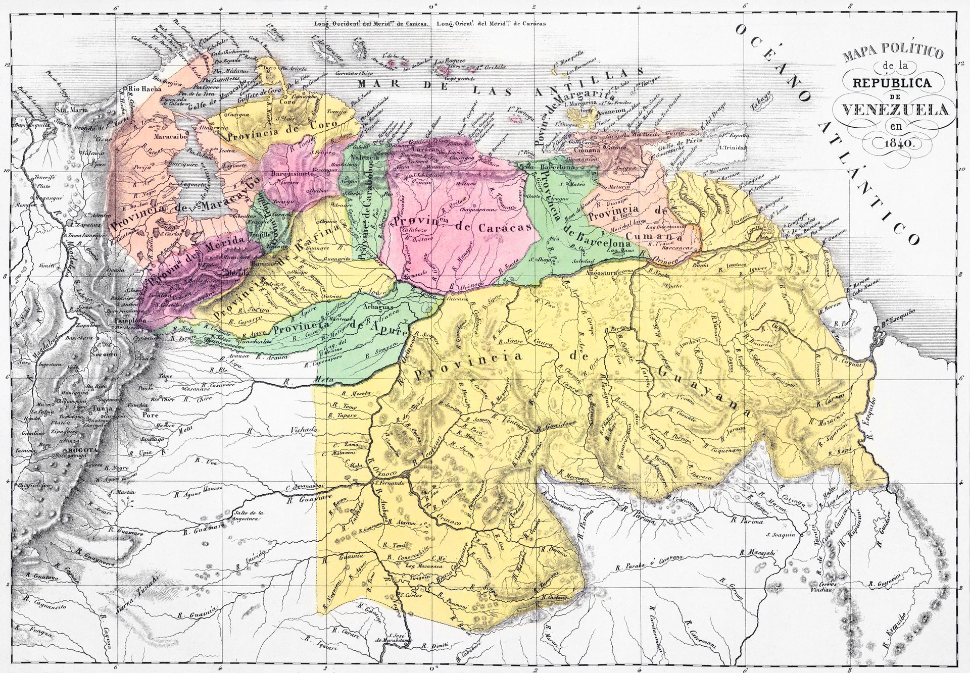
The Captaincy General did not arrive as a single decree. It was built in layers, each consolidating another thread of authority in Caracas. In 1776, Minister of the Indies José de Gálvez created the Intendancy of Caracas, unifying fiscal control over six provinces. The following year, the Royal Decree of September 8, 1777, established the joint governorship-captaincy general, subordinating regional governors and military commanders to the captain general in Caracas. Judicial unification came in 1786 with the creation of the Real Audiencia, and a consulado was established in 1793 to oversee trade. Finally, in 1803, all provinces were placed under the new Archdiocese of Caracas. What had been a collection of provinces answering to different masters was now a coherent political entity — one that, when the time came, already had the institutional skeleton of a country.
The King's Own Words
The royal decree itself reads with the formal weight of eighteenth-century Spanish bureaucracy, but its logic is practical: the provinces were too far from the viceregal capital of Santa Fe (modern Bogotá), decisions were delayed, and an invasion could exploit the administrative chaos. The king ordered "the absolute separation" of the provinces from the Viceroyalty of New Granada and their addition "in government and military matters to the Captaincy General of Venezuela." Regional governors were to obey the captain general in Caracas, and judicial appeals would flow to the Audiencia of Santo Domingo. In a later decree of 1783, Gálvez opened the island of Trinidad to immigration from the French Caribbean, a decision negotiated by Phillipe Rose Roume de Saint-Laurant. Trinidad would be lost to the British in 1797, a reminder that imperial borders were always provisional.
Independence and Its Fractures
The independence movement began on April 19, 1810, with the establishment of the Caracas Junta. After the Venezuelan Declaration of Independence in 1811, seven provinces formed the First Republic of Venezuela, claiming the territorial footprint of the Captaincy General. But not everyone agreed. Maracaibo, Guayana, and the city of Coro rejected the republic and sided with the royalists. After a year of war, the First Republic collapsed, reconquered by Frigate Captain Domingo de Monteverde. The Captaincy General was briefly split in two when the Cortes of Cádiz erected Maracaibo into a separate captaincy, though Ferdinand VII eventually reunified them. Through it all, the Real Audiencia under Regent José Francisco Heredia resisted Monteverde's attempts to impose martial law — a reminder that even within the royalist camp, the rule of law had its defenders.
The Shape of a Country
Venezuelan independence was consolidated in 1821 as part of Gran Colombia, the federation that Simón Bolívar envisioned as a continental republic. The Congress of Cucuta used the old viceregal and captaincy boundaries to define the new state's territory. But the union did not hold. Rising animosity between Venezuelans and New Granadians over how the republic should be governed led to Gran Colombia's collapse in 1830. When Venezuela emerged as an independent nation, its borders corresponded almost exactly to those of the old Captaincy General. The administrative convenience of a Spanish king, imposed to avoid "the most grave harm to my Royal Service," had become the permanent outline of a sovereign country. That is the irony of the Captaincy General: it was designed to preserve an empire and instead created the template for its dissolution.
From the Air
The Captaincy General of Venezuela was centered on Caracas, located at 10.500°N, 66.933°W, but its territory encompassed the entirety of modern Venezuela plus the island of Trinidad. From the air, the historical boundaries roughly correspond to the modern Venezuelan coastline, the Andes to the west, and the Orinoco basin to the south. Nearest airport to the colonial capital: Simón Bolívar International Airport (SVMI/CCS). The colonial center of Caracas is identifiable by its grid pattern in the valley below El Ávila.