Caracol
In 1937, a mahogany logger named Rosa Mai was pushing through the jungle of western Belize when he stumbled onto something that did not belong in the forest: carved stone monuments rising from the undergrowth, the remains of plazas and pyramids swallowed by centuries of tropical growth. What Mai had found was Caracol, a city the ancient Maya called Uxwitza — "Three Water Hill" — and what archaeologists would eventually recognize as one of the most powerful political centers in the Maya Lowlands. The winding road cut to reach the site gave it its modern Spanish name: caracol, meaning snail. The road still winds today, and the city it leads to still astonishes.
A City Larger Than Modern Belize City
Caracol's scale defied expectations for decades. Early researchers classified it as a tertiary center, a modest outpost in the Maya political hierarchy. They were wrong. At its peak during the Late Classic period, Caracol sprawled across an area larger than present-day Belize City and supported a population that may have reached 120,000 to 180,000 people — more than twice what the modern capital holds. With approximately 267 structures per square kilometer, its density exceeded that of Tikal by 85 percent. Radiating causeways connected the city's residential neighborhoods to its ceremonial core, and an extensive system of agricultural terraces sustained its enormous population. A 2009 airborne LiDAR survey mapped 200 square kilometers of the site and its surroundings, revealing settlement patterns that ground-level archaeology had missed for seventy years.
The Wars That Made an Empire
Caracol began as a client state of Tikal, the dominant power to the northwest. That relationship did not last. During the mid-sixth century, Tikal's grip weakened, and Caracol seized the opening. Yajaw Te' K'inich II, known as Lord Water, acceded to power in AD 553 and rebuilt the great pyramid of Caana, placing royal tombs within its structure. The wars with Tikal and the neighboring city of Naranjo reshaped the political geography of the Peten region. It was K'an II, however, who became Caracol's greatest ruler. Reigning for forty years from AD 618 to 658, he expanded the causeway system that stitched the city together, commissioned more stone monuments than any other king, and presided over what scholars call Caracol's golden age. Under his rule, the city's influence radiated outward through the lowlands, visible in shared ceramic traditions that spread across the region.
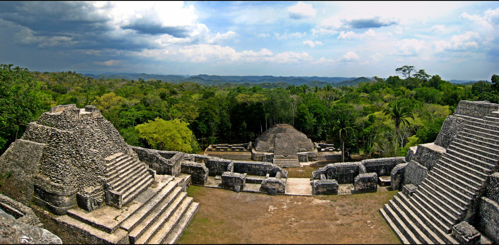
Sky-Palace on the Vaca Plateau
Caana — the Maya word means "sky-palace" — dominates the northern end of Caracol's B-Group Plaza. It remains the tallest manmade structure in all of Belize. The pyramid is not a single building but an acropolis: a massive raised platform crowned by multiple structures, courtyards, and tombs. Lord Water rebuilt it during the sixth century, and later rulers continued to modify and inhabit it through the Terminal Classic period. Excavations have uncovered royal burials, elaborate caches, and stucco masks adorning its facades. Ballcourt markers found nearby depict jaguar heads, rabbit figures, and images of the Sun God, their hieroglyphic texts recording the accession of rulers and the dedication of monuments. Below Caana, the surrounding plazas held carved stelae and altars that chronicled Caracol's dynasties across six centuries.
From Deep Time to Final Silence
People lived in the Caracol area as early as 1200 BC, though the epicentral zone was not occupied until around 650 BC. The city was formally founded in AD 331 by Te' K'ab Chaak, according to hieroglyphic records. A Teotihuacan-style cremation of three individuals, deposited in the plaza of the Northeast Acropolis during this founding era, points to early contact with the great city in central Mexico, over a thousand kilometers to the northwest. By AD 70, the Temple of the Wooden Lintel had been constructed and consecrated, and the full Maya ritual complex was in place. For nearly a millennium, Caracol grew, fought, and built. Then, like cities across the Maya world, it faltered. Structure A6 was abandoned around AD 1050, marking the final chapter of human occupation. The jungle closed in, and Caracol waited nearly nine hundred years for Rosa Mai and his search for mahogany.
From the Air
Caracol sits at 16.76°N, 89.12°W on the Vaca Plateau in the foothills of the Maya Mountains, western Belize. From 3,000–5,000 feet AGL, the cleared archaeological zone is visible as a break in the dense jungle canopy, with the massive pyramid of Caana as the most prominent feature. The site is approximately 40 km south of San Ignacio and the Macal River valley. The nearest significant airport is Philip S. W. Goldson International (MZBZ) in Belize City, roughly 80 nm to the northeast. The small airstrip at Central Farm near San Ignacio may be visible to the north. Expect tropical humidity, afternoon convective activity, and reduced visibility during the rainy season (June–December). The Maya Mountains rise to the south and east.