Carkeek Park
In November 2024, volunteers counted 1,779 chum salmon in Pipers Creek -- a record for a waterway that had held just 54 fish five years earlier. The creek runs through Carkeek Park, a 216-acre wedge of forest and beach on Seattle's northern edge, and the salmon's return is one of the most improbable urban wildlife stories in the Pacific Northwest. Fifty years of absence, decades of restoration work, a name in Lushootseed -- kwaateb, meaning "place where people are sent" -- and then the fish came back. Then the beavers showed up and built a dam.
A Canyon That Resisted the City
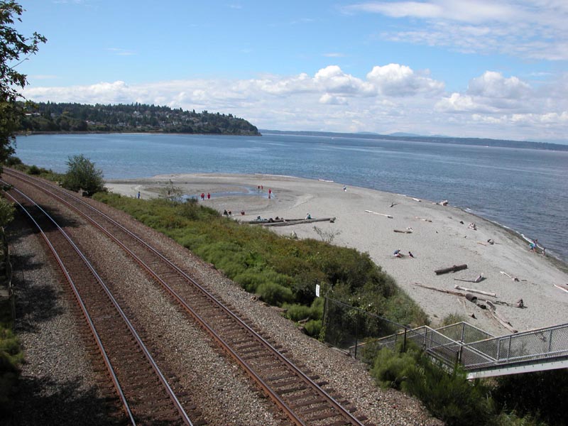
Carkeek Park occupies a steep canyon on Puget Sound in Seattle's Broadview neighborhood, and its rugged terrain is the reason it still exists. While the rest of northern Seattle was clearcut, graded, and built over during the twentieth century, this ravine was too difficult to develop easily. The original park was elsewhere -- the name belonged to Morgan and Emily Carkeek, who donated $25,000 for parkland in the 1920s. When the federal government condemned that first site for Naval Station Puget Sound, the city used the Carkeek gift and $100,000 of its own funds to acquire the canyon. The new Carkeek Park was re-dedicated on July 9, 1955, after renovations that added paved roads, beach and picnic areas, and an archery range. The archery range lasted until 1985, when neighbors complained about stray arrows.
From Clearcut to Comeback
The old-growth forest that once covered the canyon was logged off by the early twentieth century. What grows there now is a mature maple-alder forest in a successional stage, with Western red cedar and Douglas fir slowly reclaiming their dominance. Wetlands host cattails and sedges. Huge lady ferns fill the ravine between 105th and 110th streets. The park's six miles of trails pass through saltwater, riparian, wetland, upland forest, and meadow habitats, with views of the Olympic Mountains across Puget Sound. During World War II, the park briefly served as an Army camp. It has hosted outdoor performances, provided feed for zoo animals, and nurtured one of King County's largest master gardener demonstration gardens -- an acre of themed beds teaching home gardeners how to create wildlife-friendly spaces. The Environmental Learning Center, Seattle's first LEED Gold-certified city building, featured rooftop rainwater harvesting and solar panels before closing in 2013 due to budget cuts.
The Salmon and the Beavers
The centerpiece of Carkeek Park's ecological story is Pipers Creek, where chum salmon returned in 1987 after a fifty-year absence. The comeback was engineered by the Carkeek Watershed Community Action Project, launched in 1979 with support from the Suquamish Tribe, state agencies, and Seattle Public Utilities. Improved stormwater management gave the salmon a fighting chance. Every November, crowds gather for the Salmon Celebration to watch the spawning run. The creek had reached desperate lows -- 54 fish in 2019, 190 in 2020 -- before the 2024 record of 1,779 salmon. But nature had a complication in store. In autumn 2023, beavers took up residence near the creek's outlet into Puget Sound and built a dam, altering the waterflow and creating an unexpected management headache. The beavers are doing what beavers do. The salmon are doing what salmon do. The humans are trying to figure out how to let both succeed.
The Purple Salmon Slide
Carkeek Park's playground, completed in 1997 after years of planning and $275,000 in funding, was designed to teach children about the Pipers Creek watershed through play. Its centerpiece is a 19-foot purple salmon slide -- the kind of design choice that could only emerge from a community that built a park around a salmon run. Tiny caves and a flowing stream round out the playground's ecological theme. Local parents and neighbors did much of the physical labor. It is a small detail in a 216-acre park, but it captures something essential about Carkeek: this is a place where conservation is not a policy abstraction but a lived community practice, passed down through volunteer counting programs, demonstration gardens, and a giant purple fish that children slide down on autumn afternoons.
From the Air
Located at 47.710N, 122.372W on the northern shoreline of Seattle along Puget Sound. The park is visible as a large forested canyon cutting down to the beach between residential neighborhoods. Railroad tracks run along the shoreline. Best viewed at 1,500-2,500 feet AGL approaching from over Puget Sound, where the Olympic Mountains form the backdrop. Nearest airports: Boeing Field/King County International (KBFI), 8 nm south; Kenmore Air Harbor (S60), 6 nm east.