Carleton Martello Tower
The tower was already obsolete before its mortar dried. Construction began in 1813 on a rocky cliff above Saint John's western approaches, built to repel an American overland invasion that never came. By the time the circular masonry walls reached their full 30 feet of height in 1815, the War of 1812 was over. The guns specified in the original plans -- three 4-pounders and two 24-pounders -- were never installed. Yet this seemingly purposeless fortification would go on to serve in every major conflict Canada faced for the next 130 years, reinventing itself with each new war.
A Corsican Idea on a Canadian Cliff
The design traces back to a frustrating British experience on the Mediterranean island of Corsica in 1794, when Royal Navy warships struggled to overcome a single round tower at Cape Mortella. The stubborn effectiveness of that tower inspired the British to replicate the concept across their empire -- sturdy, circular, thick-walled structures that could absorb naval bombardment and deliver punishing fire from their rooftop batteries. They built dozens, from Ireland to Halifax to the Caribbean. Carleton Martello Tower, 50 feet in diameter and perched on a natural rocky pedestal overlooking the Bay of Fundy, became the third link in Saint John's defensive chain. Fort Howe protected the river narrows to the north, Fort Dufferin guarded the harbour entrance near Partridge Island, and the Martello Tower watched the western landward approaches. Together they formed a triangle of stone around one of British North America's most important ports.
Fenians, Powder, and a Pair of 32-Pounders
For decades after its construction, the tower sat quiet. In 1846, a bombproof magazine was built inside the structure, and from 1859 to 1866 it served as a powder magazine -- a stone vault packed with explosives at the edge of a civilian city. The tower found its first real purpose in 1866, when Irish-American Fenian veterans of the Civil War threatened to invade Canada. Two 32-pounder guns were hauled up the cliff and installed on the tower's platform. The New Brunswick Regiment of Garrison Artillery manned the position, scanning the horizon for raiders who never appeared in force at Saint John. The guns came down in 1877, and the tower cycled through a stint as a barracks before settling into quiet dormancy. During the First World War, it served an unlikely role as a detention centre for deserters of the 69th Battalion, housing men who had tried to flee the war between November 1915 and April 1916.
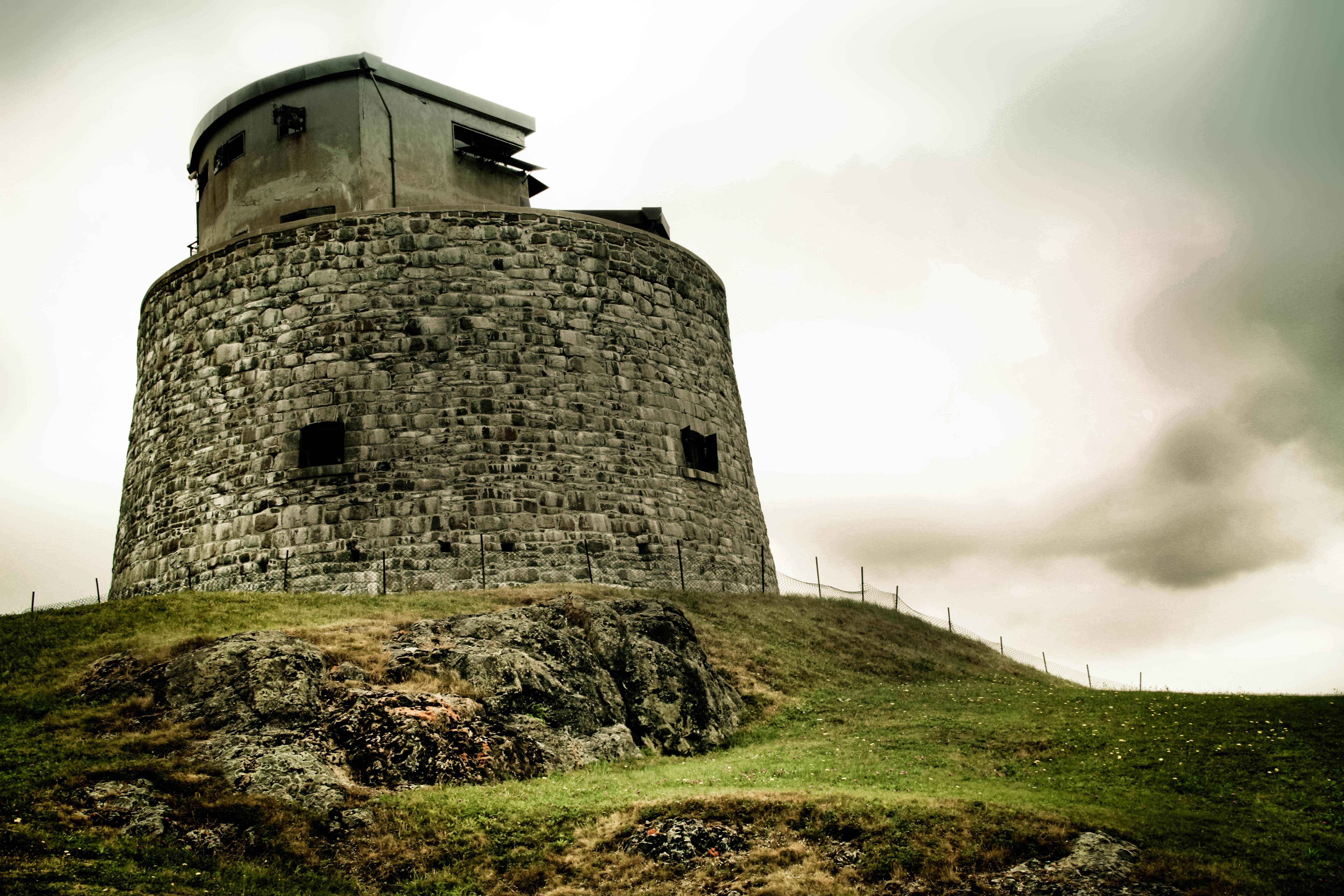
Concrete Crown for a New Kind of War
The Second World War demanded something the tower's original builders could never have imagined. In late 1939, the 8th Anti-Aircraft Battery mounted machine guns on the upper level. But the real transformation came in August 1941, when a two-storey concrete structure was placed directly on top of the old stone tower -- a brutalist crown on a Georgian head. This addition converted the Martello Tower into a Fire Command Post, coordinating anti-aircraft and coastal defenses across Saint John Harbour. A No. 3 Mark 4 telescope arrived in April 1942, followed by a No. 10 Director. By May 1943, a Mark II Position Finder completed the array of fire-control equipment. Soldiers of the 3rd New Brunswick Coast Brigade manned the position until August 1944, watching for threats that the tower's builders, with their smoothbore cannons and stone walls, could not have conceived.
The View from the Roof
Today the tower stands as a National Historic Site, designated in 1930 and open to the public since 1963. The restored powder magazine and barracks room offer a glimpse into the cramped world of garrison life, but the real draw is the rooftop. From the tower's stone parapet, the entire geography of Saint John's defense makes sudden sense. The harbour spreads below, the Saint John River curls toward the Bay of Fundy, and Partridge Island sits at the harbour mouth like a sentinel. The concrete World War II addition still sits atop the original masonry, a visible timeline of military technology stacked in layers. The tower is one of the oldest buildings in Saint John, a city that has burned and rebuilt itself repeatedly. That it survives at all -- a fortification built too late for one war, repurposed for three more, and finally preserved as a monument -- says something about the stubbornness of stone and the unpredictability of history.
From the Air
Located at 45.2521N, 66.076W on a rocky cliff on the west side of Saint John Harbour. The squat circular tower with its WWII-era concrete addition is visible from low altitude. Best viewed approaching from the southwest over the Bay of Fundy. Nearest airport: Saint John Airport (CYSJ), approximately 15 km east. The harbour, Partridge Island, and the Saint John River mouth are all visible landmarks for orientation.