The Breach That Drained a Sea
Somewhere between 640,000 and 700,000 years ago, a wall of water punched through the Coast Range and never stopped flowing. The Carquinez Strait -- eight miles of churning tidal channel connecting Suisun Bay to San Pablo Bay -- is the scar left by that cataclysm. Every drop of rain that falls on 40 percent of California's surface eventually funnels through this gap: the Sacramento and San Joaquin Rivers, draining 62,500 square miles of watershed, have no other path to the sea. The Karkin people, a division of the Ohlone, lived on both banks and gave the strait its name -- los Carquines, the Spanish called them. Today, bridges and power lines span the narrows, and cargo ships bound for the ports of Sacramento and Stockton navigate its deep channel. But the strait's real story is written in geology, in the tension between fresh water and salt, and in the human ambition to control what nature carved.
When the Lake Broke Through
During the ice ages, the Central Valley was not a valley at all. It was the floor of Lake Corcoran, a vast inland sea fed by snowmelt pouring off the Sierra Nevada. The lake originally drained south through a valley near present-day Monterey, but seismic activity along the Coast Range slowly raised the mountains and plugged that outlet. Water kept rising. At some point, the pressure became too much, and the coastal barrier between what are now Crockett and Benicia collapsed. Geologist Andrei Sarna-Wojcicki of the U.S. Geological Survey estimates the resulting flood was cataclysmic -- a wall of fresh water carving a permanent channel through rock and sediment. The lake emptied, the valley floors emerged, and California's great agricultural heartland was born. The narrow gap that remained became the Carquinez Strait, a bottleneck that has shaped the region's hydrology, ecology, and human history ever since.
A Delta Built Backward
Most river deltas fan outward at the coast, depositing sediment where current meets ocean. The Sacramento-San Joaquin River Delta does the opposite. Because the Carquinez Strait is too narrow to flush heavy floodwaters quickly, the Delta upstream acts like a basin -- first to fill during storms, last to drain. Silt and soil drop out of suspension while the water waits its turn to squeeze through the gap, building an inverted delta that spreads inland rather than seaward. It is one of the rarest geological formations on Earth, and it exists because of a strait that measures barely a mile across at its narrowest. This quirk of geography created the labyrinth of islands, channels, and marshes that would later become some of California's most productive farmland -- and one of its most politically contested landscapes.
The Salt Line
Fresh water is lighter than seawater. Where the two meet in the strait, an invisible boundary forms -- a halocline that shifts with the tides, the seasons, and human demand. By the early twentieth century, Delta farmers who irrigated their fields from the Sacramento and San Joaquin noticed the salt creeping farther inland each year. The cause was straightforward: more water was being pumped from the rivers than rain and snowmelt could replace. Politicians and farmers agreed on a bold solution -- dam the Carquinez Strait itself, walling off the Pacific entirely. In 1923, the California Legislature appropriated funds for a survey, and the federal government matched them through the U.S. Reclamation Service. Three sites were studied; Army Point near Benicia was chosen in 1928. The Salt Water Barrier became official state policy in May 1929. Then the Great Depression arrived. On January 24, 1930, President Herbert Hoover cancelled the project as too costly. The dam was never built. Instead, decades later, the Central Valley Project attacked the salinity problem from the other direction -- constructing dams far upstream and digging canals to redistribute fresh water across the San Joaquin Valley.
Bridges, Pylons, and Deepwater Ships
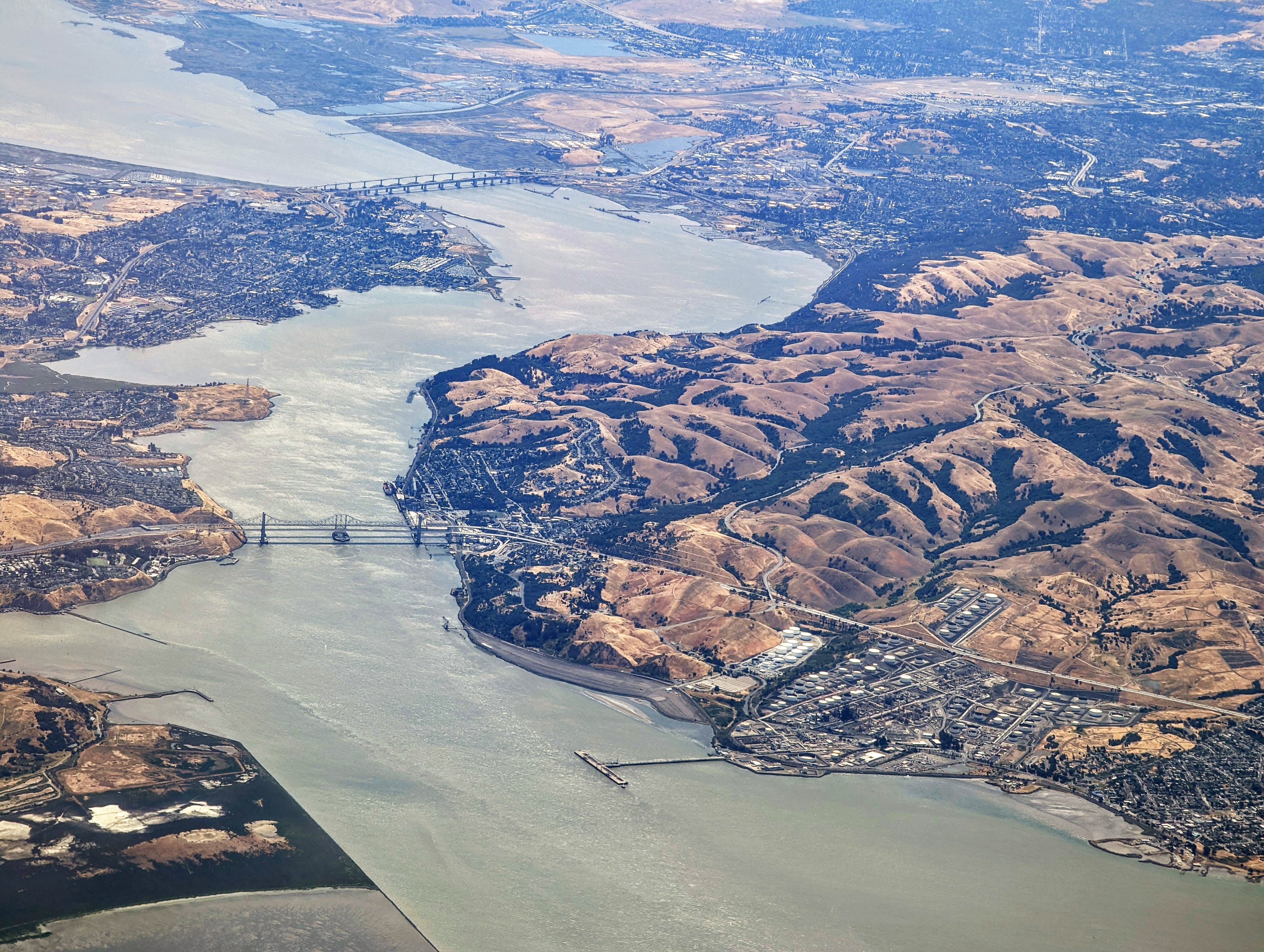
For all its geological drama, the Carquinez Strait is also a working waterway. The Baldwin Deepwater Shipping Channel runs through it, carrying commercial and military vessels to the Port of Sacramento and the Port of Stockton via the Stockton and Sacramento deep water channels. On the banks, the small towns of Benicia and Vallejo face Martinez, Port Costa, and Crockett across the narrows. Two bridges carry traffic over the water, and the Napa River enters nearby through the short Mare Island Strait. Tall pylons stride across the gap as well -- the Carquinez Strait Powerline Crossing was the world's first powerline crossing of a major river, a feat of engineering that matched the strait's own improbable geography. From above, the strait reads clearly: a thin blue line where the brown hills pinch together, the funnel through which California's interior breathes.
From the Air
The Carquinez Strait is at approximately 38.054N, 122.189W, clearly visible as a narrow water channel connecting Suisun Bay to San Pablo Bay. Two bridges span the strait, making it easy to identify. Best viewed at 2,000-4,000 feet AGL. The cities of Benicia and Martinez flank the strait on north and south. Nearby airports include Buchanan Field (KCCR) in Concord, about 10 nm south, and Napa County Airport (KAPC), roughly 15 nm northwest. On clear days, the strait is visible as the only gap in the Coast Range hills separating the inland valleys from San Francisco Bay.