
Carrawburgh
Imagine a Roman soldier from the Low Countries, posted to the cold edge of the empire, descending into a low stone chamber built to look like a cave. Inside, candlelight throws shadows on a relief of a young man stabbing a bull. The benches are raised. A wattle screen separates the anteroom from the nave. Outside, the wind crosses Northumberland's moors and rattles the wooden door. This is third-century Britain. The soldier is here to worship Mithras, a god from Persia, in a temple built at a Roman fort called Brocolitia, which probably means 'badger holes' in a Celtic tongue. The fort itself was an afterthought, slotted into a gap on Hadrian's Wall a few years after the rest of the wall went up. Today only the earthworks remain, but Carrawburgh holds one of the finest Mithraea ever found in Britain.
A Gap on the Wall
Hadrian's Wall was largely complete by the late 120s AD, but the regular spacing of forts left an awkward stretch between Housesteads, 5.2 miles east, and Chesters, 3.5 miles west. Around AD 130, the Romans decided to fill that gap with a new auxiliary fort. They called it Brocolitia, or Procolita, or Brocolita depending on which surviving document you read. The name is found in the fifth-century Notitia Dignitatum and in the seventh-century Ravenna Cosmography, and it almost certainly preserves an older Celtic name for the place. One scholarly suggestion: 'badger holes.' The fort was inserted so late that part of the existing Vallum, the great earthwork south of the wall, had to be filled in to make room. A fragmentary inscription, now in the Chesters Museum, points to a construction date around AD 130. The fort covered roughly 1.5 hectares, modest by the standards of the wall, but strategically essential.
Garrisons from Across the Empire
The Roman Inscriptions of Britain catalogue 48 inscriptions from Carrawburgh, and they trace a remarkable parade of units that passed through. Cohors I Tungrorum, from the Low Countries, garrisoned the fort from roughly 122 to 138, then moved on to Housesteads. Cohors I Aquitanorum, from south-western Gaul, arrived around 133. By the end of the second century, Cohors I Cugernorum, recruited from the Rhineland, was in residence. From 213 onward, Cohors I Batavorum, another Low Countries unit, served at the fort across at least three separate stints stretching into the year 400. The First Cohort of Frisiavones, from the Frisian coast, also appears in the inscriptions. None of these soldiers were Roman in the strict sense. They were auxiliaries, recruited from across the empire, who earned citizenship through service. The northern frontier of Britain was held, in practice, by Tungrians and Batavians and Frisians, men whose home rivers ran into the North Sea.
The Temple of Mithras
The most famous discovery at Carrawburgh sits just outside the south-west wall of the fort. The Brocolitia Mithraeum was built to resemble a cave, as Mithraic temples almost always were. The cult was a mystery religion, popular among soldiers, with secret initiations and a complex hierarchy of grades. Worshippers descended into the dim chamber, took their places on the raised benches called podia, and faced the relief of Mithras slaying the bull. At Carrawburgh, archaeologists found the temple had been built and rebuilt three times. The anteroom and nave were separated by a wattle-work screen whose base survived in remarkable condition. Nearby, the Romans built a separate shrine to the Nymphs and the Genius Loci, the spirit of the place. When the second Mithraeum was constructed, materials from this nymph shrine were reused, though the altar was preserved. A destruction layer dating to roughly AD 300 closed both shrines, possibly during a period when Christian soldiers had little patience for the old mysteries.
Coventina's Well
Beyond the fort, in the vicus (the civilian settlement that grew up alongside), the Romans honoured another deity: Coventina, a goddess of springs whose worship is recorded almost nowhere else in the empire. Her shrine was a small temple over a well or spring, and Victorian excavations recovered over 13,000 coins from the water, along with altars, votive offerings, and inscriptions. One altar tells us that Optio Maus of the First Cohort of Frisiavones had repaid a vow to Coventina, though whether the altar itself was the repayment is anyone's guess. The well and shrine are no longer visible above ground, but the inscriptions survive.
Gift to the Nation
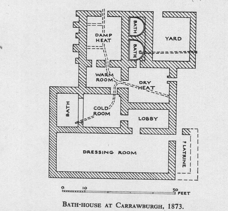
For decades Carrawburgh sat on private land. Only the fort's earthworks remain visible: the Wall here and the fort's north rampart were demolished in the eighteenth century to build General Wade's military road, now the B6318, which runs directly past the site. The late nineteenth-century antiquarian John Clayton, who also planted the Sycamore Gap tree a few miles west, partially excavated the fort, revealing the military bath-house outside the west gate in 1873 and the south-west corner tower in 1876. In January 2020, Jennifer Du Cane, whose family had owned the site since the 1950s, gifted the fort to the nation. It now belongs to Historic England and is administered by English Heritage. Visitors can walk the grass earthworks, descend into the Mithraeum (a 1950s reconstruction with replica altars; the originals are at the Great North Museum in Newcastle), and stand where Tungrian soldiers once watched the northern horizon.
From the Air
Coordinates: 55.035°N, 2.222°W. Recommended viewing altitude 2,000-4,000 ft AGL. The fort earthworks sit immediately south of the B6318 Military Road, which traces the demolished line of Hadrian's Wall at this point. The Mithraeum reconstruction is visible as a small rectangular structure just west of the fort outline. Northumberland National Park airspace. Nearest airports: Newcastle (EGNT) approximately 22 nm east-southeast, Carlisle Lake District (EGNC) approximately 27 nm west-southwest.
Nearby Stories
- Battle of Alnwick (1174) 5.7 km away
- Allenheads 5.8 km away
- Mitford Castle 6.4 km away
- Battle of Nesbit Moor (1355) 11 km away
- Battle of Arfderydd 12 km away
- Battle of Neville's Cross 13 km away
- Battle of Philiphaugh 19 km away
- Caldbeck 20 km away