Carriacou
The name the island's pre-Columbian inhabitants gave it was Kayryouacou -- "surrounded by reefs." For centuries, those reefs were a problem. They cramped shipping lanes, frustrated plantation owners, and kept Carriacou marginal even by Caribbean colonial standards. Today, the reefs are the reason people come. Grenada's second-largest island, roughly 13 square miles in area, Carriacou is home to about 9,600 people and a pace of life that makes the rest of the Caribbean look hectic. The coral that hemmed in commerce now draws divers from around the world, and the island's colonial past -- French, then British, then independent -- has left behind a landscape layered with plantation ruins, French place-names, and traditions that blend African, European, and Venezuelan influences into something entirely its own.
Empires Passing Through
Carriacou was settled long before the Kalinago arrived from South America between 500 and 1200 AD, though whether the earlier inhabitants and the newcomers coexisted or clashed remains unclear. The first European recorded to set foot on the island was Jean-Baptiste Du Tertre in 1656, a French Dominican friar who documented much of the Lesser Antilles. France colonized Carriacou and held it until 1763, when defeat in the Seven Years' War forced them to cede Grenada and its dependencies to Britain. The British developed sugar plantations and populated the island with enslaved Africans brought to work them. France briefly recaptured Carriacou in 1779 while supporting the American Revolution, but the 1783 Treaty of Paris returned it to Britain. During this turbulent interchange, the largest landowner and slaveholder on Carriacou was Judith Philip, a free Black woman -- a detail that complicates any simple narrative of colonial power. The islands remained British until Grenadian independence in 1974, but French patois and place-names persist across the landscape.
Island of Reefs and Ruins
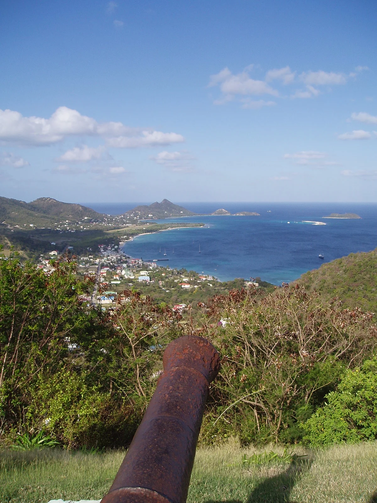
Carriacou's highest point, at 291 meters, rises through dense woodland where iguanas, land tortoises, soldier crabs, hummingbirds, and macaws share the canopy. The trails are poorly marked, and a guide is worth the hire -- not for safety so much as for the wildlife spotting. Below the ridgeline, the coast unfolds in a series of bays that range from pristine to haunted. Anse La Roche, on the northwest corner, offers a beach you may have entirely to yourself, with fort and plantation ruins at its southern end. On the east coast, the sea is gradually washing away an old cemetery, exposing graves on a macabre beach where the Ningo Well, one of the earliest wells on Carriacou, is under archaeological excavation. Near Belair, an 8-meter sugar mill tower stands as a remnant of the plantation era. By the south coast, the ruins of a cotton and lime processing operation include original machinery and a stone chimney that has outlasted the enterprise it served.
Hillsborough and Tyrell Bay
Hillsborough, the only real town, is atmospheric rather than picturesque. The waterfront is sandy but narrow, the buildings dilapidated in a way that suggests honest aging rather than neglect. You can walk the whole place in half an hour. During the 20th century, the harbor here served as the island's main port, but with the construction of a new marina at Tyrell Bay on the sheltered southwest coast, the center of gravity has shifted. Tyrell Bay, also known as Harvey Vale, is now the ferry port, connecting Carriacou to St. George's on Grenada by a 90-minute sailing. Small turboprop planes -- BN Islanders and Twin Otters -- fly once daily from Grenada's Maurice Bishop Airport to Lauriston Airport, a modest strip two miles west of Hillsborough. The December-to-April dry season brings the best weather. Carriacou sits clear of the main hurricane belt, though storms have struck in 1944, 1955, 2004, 2005, and 2024.
Carnival, Parang, and the Regatta
What Carriacou lacks in size it compensates for in cultural density. Carnival arrives just before Lent, filling the streets with parades of oily jab-jabbers, Shakespeare recitation competitions -- a tradition where contestants try to out-declaim each other from memory -- and quantities of rum that render much of the island incoherent by Ash Wednesday morning. The Carriacou Maroon and String Band Festival, usually in April, celebrates African-rooted music and storytelling. In August, the Carriacou Regatta draws locally built boats for racing on the first weekend, though the shore-side festivities have long since eclipsed the sailing. Then, on the weekend before Christmas, comes Parang -- a tradition that originated in Venezuela, where promenading musicians go door to door. On Carriacou, Parang has blended with Christmas carols and calypso satire into something distinctly Grenadian. Between festivals, the main activity is diving. The reefs that gave the island its name shelter coral gardens and underwater terrain that three dive operations work year-round.
From the Air
Located at 12.47N, 61.45W in the southeastern Caribbean, between Grenada to the south and the Grenadines to the north. The island is clearly visible from altitude as a compact landmass surrounded by lighter turquoise reef water. Tyrell Bay on the southwest side and Hillsborough on the west are the main coastal features. Lauriston Airport (MKCA) on the west coast handles small turboprops. Grenada's Maurice Bishop International Airport (TGPY) is roughly 20 nm south. Union Island's J.F. Mitchell Airport (TVSM) in Saint Vincent lies to the north. Expect trade wind clouds; best visibility December through April.
Nearby Stories
- Canouan 6.9 km away
- Grand Etang Lake 39 km away
- HMS Grenada (1804) 92 km away
- Little Tobago 126 km away
- Mount Gay Rum: Three Centuries in a Glass 139 km away
- 1766 Southeastern Caribbean Earthquake 143 km away
- Macuro 194 km away
- Operation Neuland 235 km away