Cârța Monastery
The monks who arrived in the Olt River valley around 1205 built their first structures from wood, as Cistercian custom required. The order that had preached austerity at Cîteaux Abbey in Burgundy carried that principle to the edge of the known world -- southern Transylvania, a frontier territory where the Făgăraș Mountains wall off the horizon to the south and the river marks the northern boundary of arable land. Within a decade, the Cistercians at Cârța had replaced their wooden buildings with a small stone chapel, the oratorium. Within two decades, they had begun the main church. They would not finish it for eighty years, because the Mongols came first.
A Foundation in Latin and Ambiguity
Nobody knows the exact year Cârța Monastery was founded. A document from 1418, issued by Sigismund, King of Hungary, at Konstanz, mentions that his predecessors founded and endowed the monastery -- but declines to specify when. Another document, the act disbanding the monastery in 1474 under Matthias Corvinus, references its royal establishment without dating it further. The best evidence comes from an Arpadian royal document of 1223, which describes the monastery's territory as a gift from a nobleman named Gocelinus, granted through the Transylvanian Voivode Benedict, who held office between 1202 and 1209. A 1206 record from the General Chapter of the Cistercian Order mentions a monk from Transylvania attending the mother abbey at Cîteaux -- almost certainly from Cârța. Piecing these fragments together, historians place the founding between 1202 and 1206. The monks came from Igriș Abbey in the Banat plain, itself a daughter house of Pontigny Abbey in France. Burgundian discipline, transplanted to the Carpathian frontier.
Before and After the Mongols
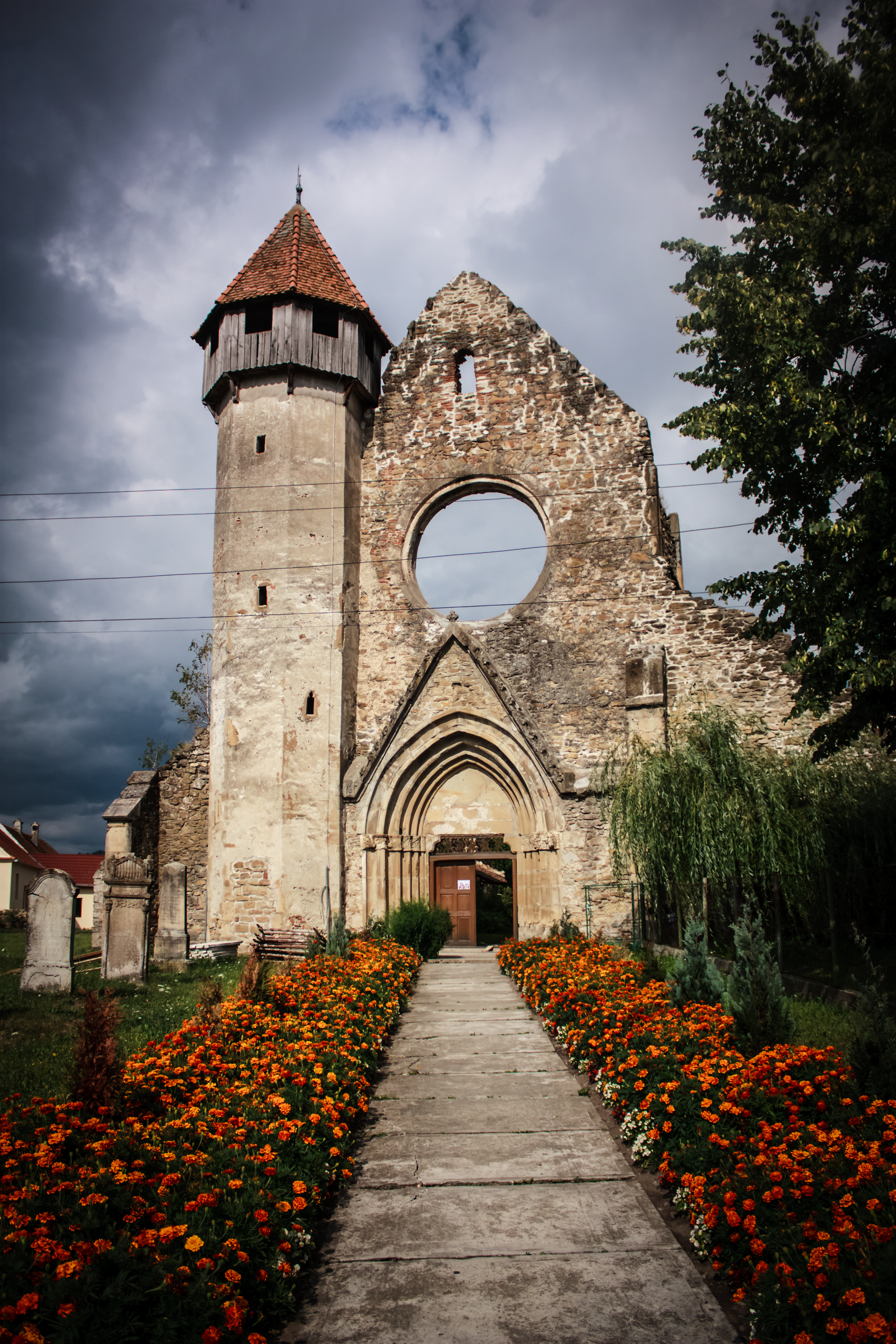
Construction of the main stone church began around 1220, and the builders worked in the Romanesque style -- heavy walls, round arches, the kind of architecture that projects permanence. They had raised the walls to about three or four meters when the Mongol invasion of 1241 swept through Transylvania, leaving devastation across the region. Construction halted. When work resumed around 1260, a new architect took charge, one trained in the mature Gothic style that had spread across Europe during the intervening decades. The shift is legible in the building itself: the lower portions carry the weight and solidity of Romanesque design, while the upper sections soar with pointed arches, ribbed vaults, and a polygonal apse that could belong to a church in northern France. The old stone oratorium was dismantled, its foundations repurposed as the base for the north wing of the transept. By 1300, the church and the east wing were complete. Work on the south side continued for another twenty years.
Ten Villages and an Empire of Wool
A document from 1322, issued by King Charles I of Hungary, reveals the scope of the monastery's temporal power: ten villages belonged to Cârța, stretching across the territory between Sibiu and Brașov and into the Târnava Mare River valley. The monks had founded several of these settlements themselves, populating them with German colonists -- the Transylvanian Saxons whose descendants still live in the region. Apoș, whose German name Abtsdorf translates to "the Monk's Village," preserves this founding relationship in its very name. Criț, Meșendorf, and Cloașterf followed, established during the 13th and 14th centuries along the Sighișoara seat. The monastery was not merely a house of prayer. It was a colonizing enterprise, an economic engine, and an instrument of frontier settlement that introduced French Gothic art to a region that had known only Romanesque forms.
Dissolution and Survival
In 1474, Matthias Corvinus initiated the monastery's disbandment, and by 1494 the apostolic legate Ursus of Ursinis formally ratified its attachment to the Provostship of Sibiu. The Cistercians departed. But the building did not vanish. It became an Evangelical Lutheran church, adopted by the local Saxon community whose ancestors the monks had helped settle there centuries earlier. The transition was practical rather than dramatic -- a shift in confession that left the architecture intact. In 1927, the Transylvanian Saxon archaeologist Victor Roth rediscovered the foundations of the original oratorium during spring excavations, adding a physical layer to the documentary evidence. Further archaeological work in 1983-1985 revealed additional details of the monastery's evolution. Today the building stands on the left bank of the Olt, between Sibiu and Făgăraș, its Gothic walls a record of eight centuries of continuous use -- from Cistercian austerity to Lutheran worship, through invasions, dissolutions, and the quiet persistence of stone.
From the Air
Located at 45.792N, 24.569E on the left bank of the Olt River in southern Transylvania, Romania, between Sibiu and Făgăraș. The monastery's stone church and tower are visible along the river valley, with the Făgăraș Mountains rising dramatically to the south. Best viewed at 2,000-3,000 feet AGL following the Olt River valley. Nearest airport: Sibiu International (LRSB), approximately 25 nm west.