Cartmel Priory
The Dissolution commissioners had clear instructions: 'Pull down to the ground all the walls of the churches, stepulls, cloysters, fraterys, dorters, chapter howsys.' The materials were to be sold for the Crown's profit. At Cartmel, in what is now Cumbria, this would have meant the destruction of one of the finest priory churches in northern England. But the villagers of Cartmel had a legal argument. When William Marshal, 1st Earl of Pembroke, founded the priory in 1190, he had given an altar within the church to the village and provided a priest to serve it. The church was the villagers' only place of worship. They petitioned to keep it, and -- remarkably -- they won.
William Marshal's Legacy
William Marshal, one of the greatest knights of the medieval world, founded Cartmel Priory for a community of Augustinian canons in 1190. He granted the entire fief of the district of Cartmel to support the new house, which was colonized by a prior and twelve canons sent from Bradenstoke Priory in Wiltshire. The priory dedicated to the Virgin Mary and St Michael grew steadily over the following centuries. Between 1327 and 1347, John Harington, 1st Baron Harington, added a chapel with four traceried windows in the south choir aisle; his tomb, shared with his second wife, still displays the Harrington knot and the Dacre scallop shells on its stonework. The gatehouse, built between 1330 and 1340, is the only surviving structure from the priory complex apart from the church itself.
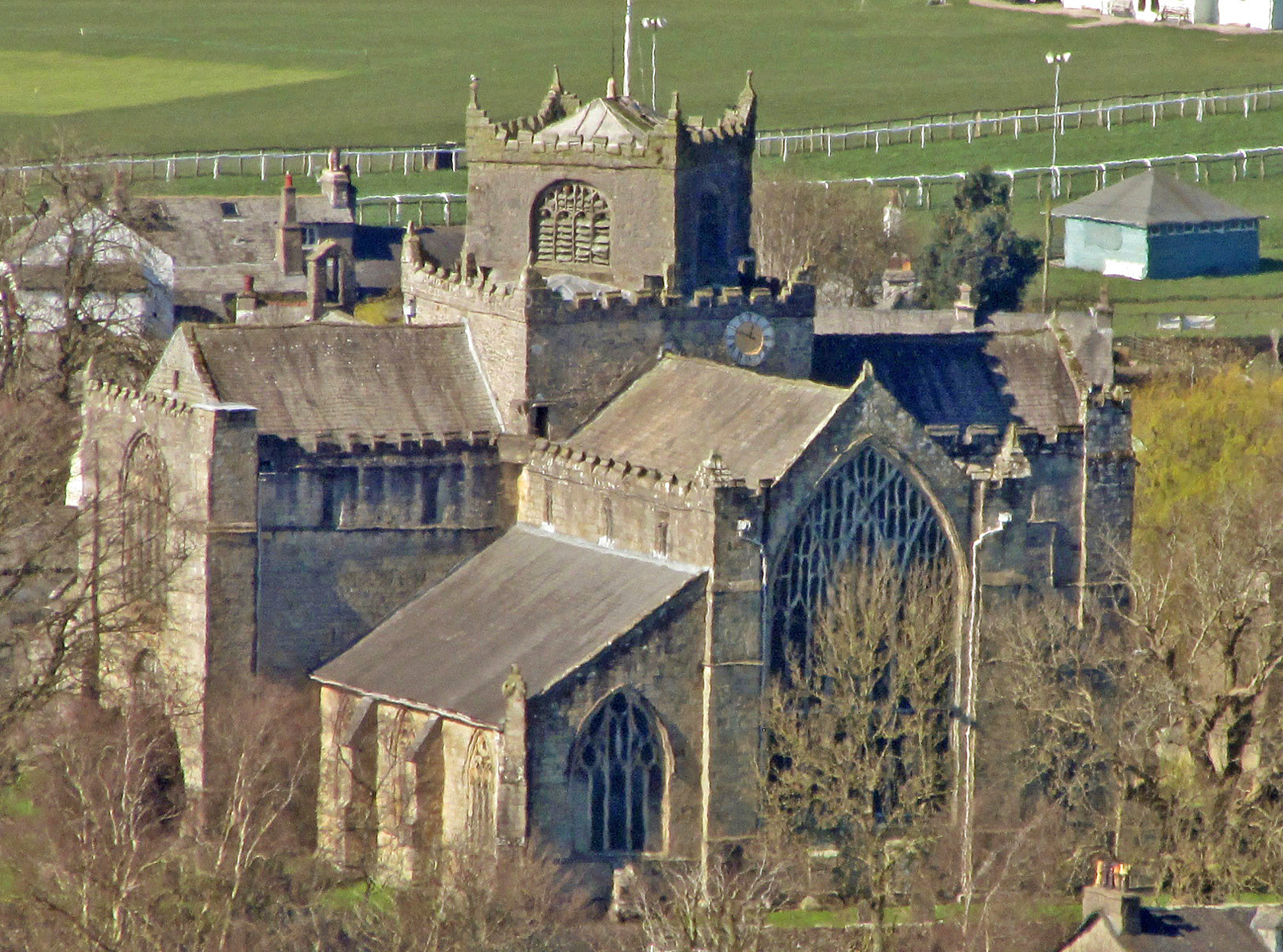
The Crooked Tower
Look up at Cartmel Priory's tower and something seems wrong. The upper stage sits at a 45-degree angle to the base on which it rests, a feature believed to be unique in England. The reason for this architectural oddity -- whether structural necessity, aesthetic choice, or medieval improvisation -- has never been satisfactorily explained. The tower was extended in the 15th century as part of extensive renovations that also replaced the early lancet windows at the east end with one enormous stained-glass window and installed 25 misericords in the choir. These carved wooden seats, dating from 1440, are of exceptional quality. Among the figures carved beneath the hinged seats is a three-headed Green Man sprouting foliage -- traditionally interpreted as a symbol of the devil, though its pagan origins run far deeper.
Rebellion and the Hangman's Rope
The priory was initially surrendered in 1536 during the Dissolution of the Monasteries, but the Pilgrimage of Grace -- the great northern Catholic rebellion against Henry VIII -- briefly restored the community. Cartmel was one of perhaps sixteen monasteries reinstated during the uprising. The prior, Richard Preston, had wisely fled to the Crown forces under the 3rd Earl of Derby, and so secured himself a pension and a parish living. Others were not so fortunate. When the rebellion failed, the subprior and several canons were hanged, along with ten villagers who had supported them. The brutality of the suppression ensured that no further resistance was offered.
Oak, Plaster, and Survival
The church that the villagers saved has been continuously used for worship since the 12th century, accumulating layers of restoration and renewal. By 1830 it needed substantial repair, and the results were described as 'more enthusiastic than sympathetic.' A more careful restoration by the architect E. G. Paley in 1867 uncovered the original massive oak timber roof, which had been hidden behind a plastered ceiling for centuries, and reglazed all the windows. The gatehouse became a museum in 1923 and was presented to the National Trust in 1946. Today the priory remains an active Anglican parish church in the diocese of Carlisle, its ancient walls still echoing with services, its crooked tower still puzzling everyone who looks up at it, and its Green Man still grinning from beneath a choir seat, as he has for nearly six hundred years.
From the Air
Cartmel Priory is at 54.20N, 2.95W in the village of Cartmel, Cumbria, on the southern edge of the Lake District between Morecambe Bay and Windermere. The priory's distinctive crooked tower is visible from low altitude among the village rooftops. Cartmel Racecourse is adjacent. Nearest airports: Barrow/Walney (EGNL, 12nm west) and Blackpool (EGNH, 25nm south). Morecambe Bay's vast tidal flats are visible to the south and east.