Cascade Range
On May 18, 1980, Mount St. Helens exploded with the force of 500 atomic bombs, blasting 1,300 feet off its summit and killing 57 people. The eruption shocked a nation that had forgotten American volcanoes could still erupt. But geologists weren't surprised - every major eruption in the contiguous United States over the past 200 years has come from the Cascades, the volcanic mountain range that runs from British Columbia through Washington and Oregon into Northern California. These are not dead peaks. They are part of the Pacific Ring of Fire, built by the slow collision of tectonic plates, and they will erupt again.
The High Cascades
The great stratovolcanoes dominate the range - massive cones that tower twice the height of surrounding peaks, their summits white with glaciers even in August. Mount Rainier, at 14,411 feet the highest point in Washington, holds more glacial ice than all other Cascade volcanoes combined. Mount Hood guards Portland's eastern horizon. Mount Shasta rises nearly 10,000 feet above the California plateau in a single unbroken slope. Mount Baker holds the American snowfall record - over 1,140 inches in the winter of 1998-99. These peaks are young by geological standards, built by repeated eruptions over the past million years, and they remain active. Rainier is considered one of the most dangerous volcanoes in America - if its glaciers melted rapidly in an eruption, lahars could reach Puget Sound communities in under an hour.
Fire and Ice
The Cascades exist because the Juan de Fuca Plate is diving beneath North America at the Cascadia Subduction Zone. As the oceanic crust plunges into the mantle, water rises and triggers melting, generating the magma that feeds the volcanoes. This same process causes earthquakes - the Cascadia fault is capable of magnitude 9 events, like the one in 1700 that sent a tsunami across the Pacific to Japan. The subduction zone explains why the Cascades are both fire and ice: volcanic heat builds the peaks while Pacific moisture dumps record snowfall on their western slopes. The mountains capture weather systems moving off the ocean, creating temperate rainforests on the windward side and near-desert on the eastern lee.
The Green Cathedral
Below the ice and rock, the Cascades support some of the most productive forests on Earth. Douglas-fir, western red cedar, and western hemlock grow to enormous size in the mild, wet climate - trees reaching 300 feet tall and living for centuries. The northern spotted owl and marbled murrelet depend on these old-growth forests; logging controversies have raged for decades over how much to preserve. Wildlife thrives: black bears, cougars, mountain goats, elk, and a few wolf packs returning from Canada. Fewer than 50 grizzlies survive in the remote North Cascades, one of the most endangered populations in the lower 48. The Pacific Crest Trail runs the length of the range, offering 2,650 miles of hiking from Mexico to Canada.
Sacred Mountains
The First Nations people gave these peaks names long before European explorers arrived. Mount St. Helens was 'Louwala-Clough' - the smoking mountain. Mount McLoughlin was 'M'laiksini Yaina.' Mount Jefferson was 'Seekseekqua.' When British explorer George Vancouver sailed Puget Sound in 1792, he renamed the peaks for British admirals and diplomats - Rainier for Peter Rainier, Baker for Joseph Baker, St. Helens for Baron St Helens. But the mountains keep their power regardless of what humans call them. They shape the climate, the forests, the rivers. They provide drinking water for millions. And occasionally, as St. Helens reminded us, they remind us who is really in charge.
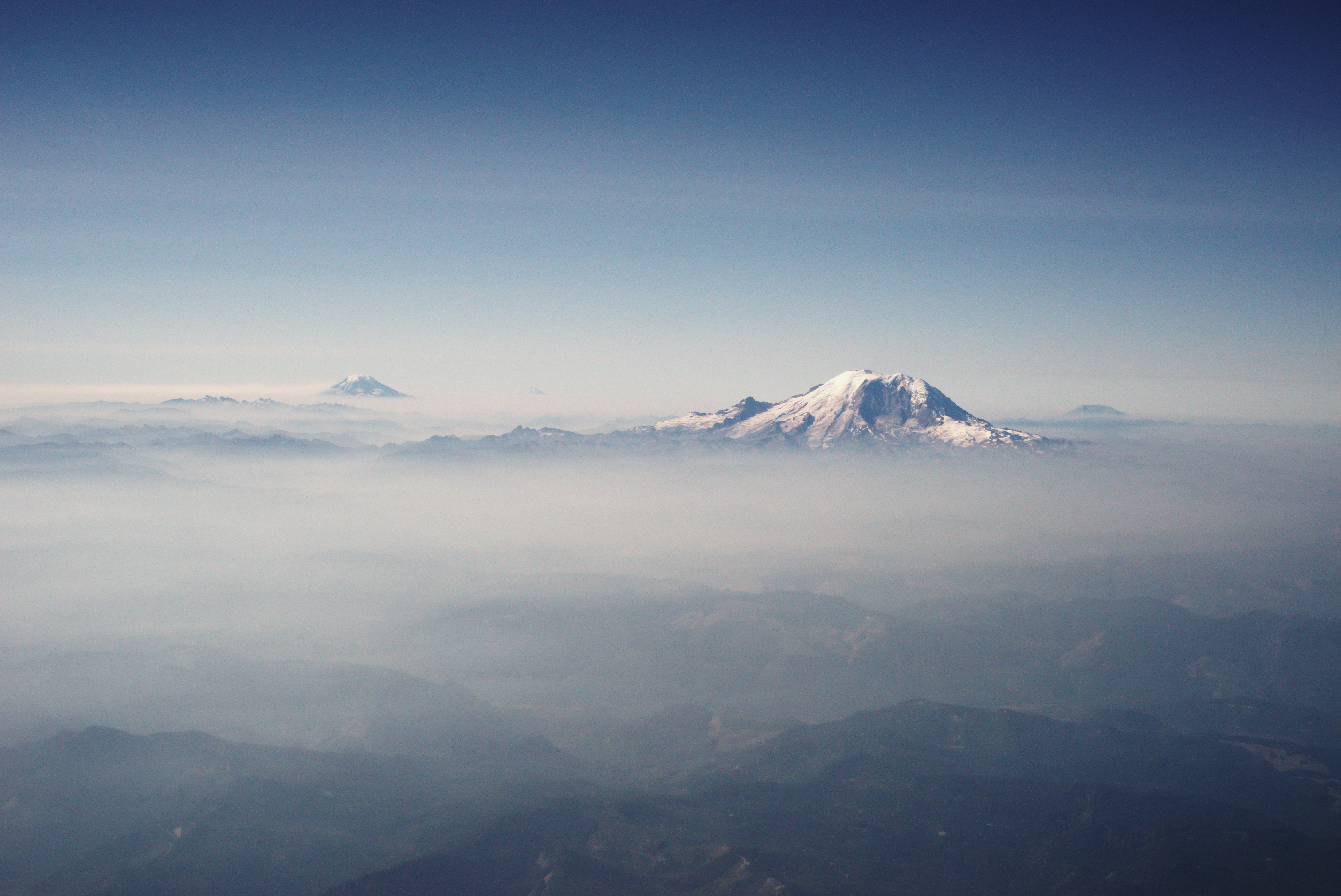
From the Air
The Cascade Range extends from Lassen Peak in Northern California (40.5°N) to the Thompson River confluence in British Columbia (50.2°N). The volcanic peaks are unmistakable landmarks: Mount Rainier (14,411 ft) dominates the Seattle skyline; Mount Hood (11,250 ft) defines Portland's eastern horizon; Mount Shasta (14,179 ft) rises dramatically from the California plateau. The Columbia River Gorge provides the only sea-level passage through the range. Expect significant terrain effects: strong downdrafts on lee sides, mountain wave turbulence, and rapidly changing weather. The western slopes receive 100+ inches of precipitation annually; the eastern rain shadow is semi-arid. Winter snow closes most mountain passes. Volcanic activity monitoring by USGS Cascades Volcano Observatory.