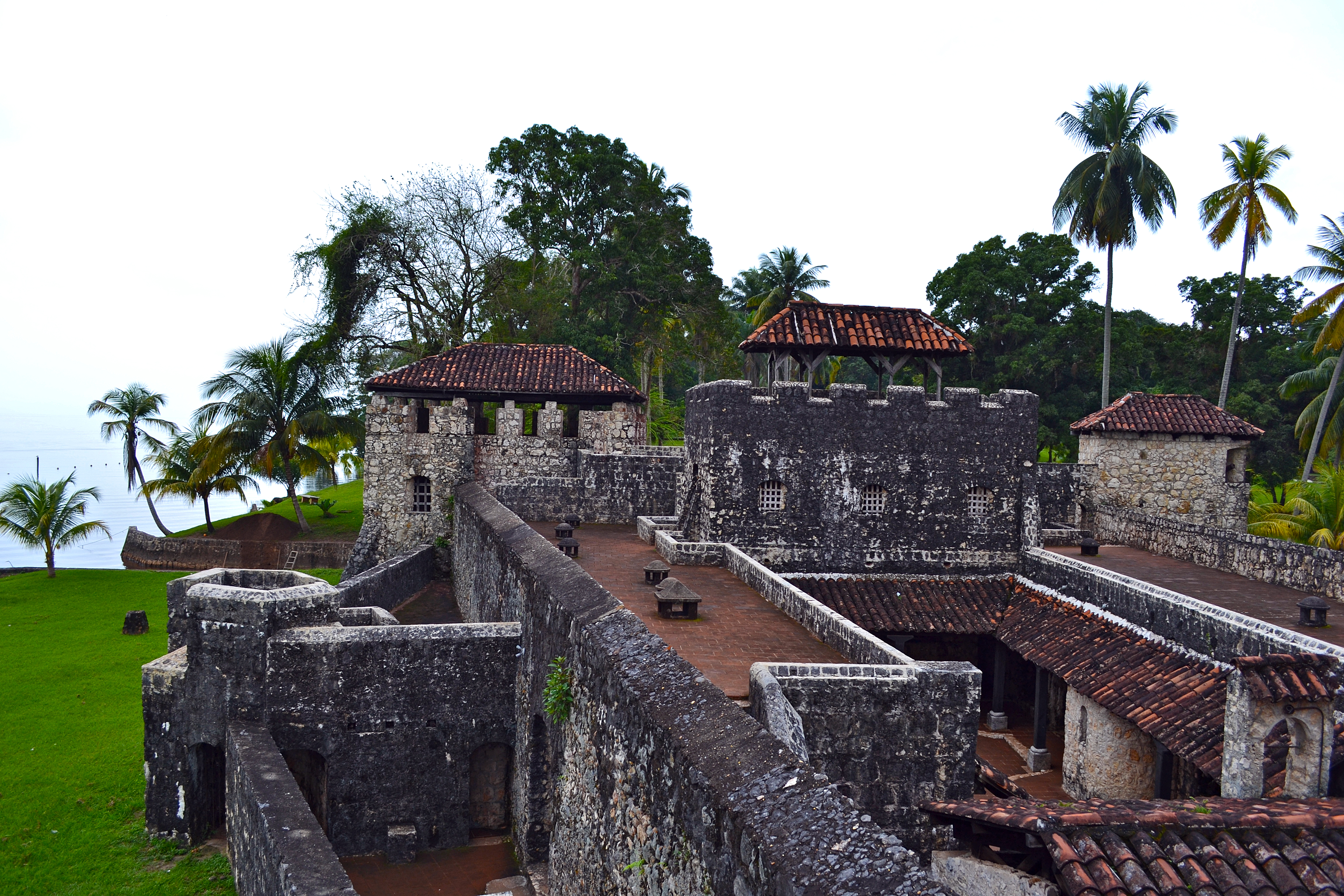
Castle of San Felipe de Lara
The logic of the fort's placement is immediately obvious. Where the Rio Dulce narrows to a bottleneck between Lake Izabal and the open water leading to the Caribbean, a stone fortress blocks the passage like a cork in a bottle. The Spanish understood in 1644 what any pirate could see from the deck of an approaching ship: whoever controlled this chokepoint controlled access to Guatemala's interior. The Castle of San Felipe de Lara was built to solve a specific problem -- English pirates kept sailing upriver and raiding the port of San Antonio de las Bodegas on Lake Izabal's south shore. The fort's history is a cycle of construction, destruction, and stubborn rebuilding that mirrors the broader story of colonial power in Central America.
Bustamente's Fort
In 1644, Diego de Avendano, governor of the Kingdom of Guatemala, ordered the construction of a fort at the river's narrowest point. The original structure was called Fuerte Bustamente and the Torreon de Defensa -- the Defence Tower. It was a practical response to a costly problem: English pirates had made raiding the Lake Izabal settlements a reliable business, and the Spanish needed a way to stop ships before they reached the lake. The fort's walls were later redesigned by Lara y Mogrovejo, an oidor -- a high judge in the colonial system -- whose surname gave the castle the second half of its name. For the Spanish, the position at San Felipe was more than military. The fort's commander also served as mayor of San Pedro de Amatique and San Antonio de las Bodegas, a joint appointment that consolidated control over the region's waterways and settlements.
Pirates, Raiders, and Abandoned Shores
The fort was destroyed and looted by pirates multiple times across the centuries, each attack demonstrating both the strategic value of the location and the difficulty of holding it. But English buccaneers were not the only threat. The Mosquito Zambo -- Indigenous and African-descended people from the Mosquito Coast -- conducted slave raids along the Motagua River delta and the shores of Lake Izabal that proved devastating to the local population. Entire settlements were emptied, their inhabitants either fleeing inland or being captured and sold into slavery in the British colony of Jamaica. The raids left the lake's shoreline largely deserted, and the towns that the fort was built to protect gradually ceased to exist in any meaningful sense. By the time a census was taken in October 1776, San Felipe counted only 122 inhabitants, all of them either Spanish or of mixed race. By 1797, the garrison had dwindled to 36 infantry -- a skeleton crew guarding a passage to a lake whose shores had been emptied by the very violence the fort was meant to prevent.
Earthquakes and Afterlives
The fort survived pirates and raiders, but the earth itself proved harder to resist. On July 11, 1999, an earthquake cracked the castle's walls, causing significant structural damage. The Guatemalan Institute of Tourism, INGUAT, which administers the site, oversaw repairs, and the fort has since become one of Guatemala's more visited historical attractions. Between 2001 and 2003, visitor numbers jumped from 45,652 to over 156,000, more than 90 percent of them Guatemalan. The Castle of San Felipe de Lara is not a ruin in the romantic European sense -- it is compact, restored, and surrounded by water on three sides, its stone walls reflecting in the river's surface. Environmental concerns shadow the site: the river water around the fort has been found to be heavily contaminated with coliform bacteria from local pollution, a modern threat that neither cannons nor thick walls can address.
The River Road to the Caribbean
The castle's setting remains its most powerful feature. Lake Izabal, Guatemala's largest lake, connects to the Caribbean Sea through the Rio Dulce and the broad, shallow expanse of El Golfete. The fort sits exactly where the water funnels from one world to another -- freshwater lake to tropical river to open ocean. From the battlements, the view downstream reveals the limestone cliffs and jungle canopy of the Rio Dulce gorge, one of Guatemala's most scenic waterways. Upstream, Lake Izabal stretches to the horizon. The Spanish chose this spot because geography left them no choice, and geography has ensured that the fort remains relevant long after the pirates and the garrison commanders are gone. It is a place where the physical landscape tells the human story: control the narrows, and you control the trade.
From the Air
The Castle of San Felipe de Lara sits at 15.637N, 88.993W at the point where Rio Dulce exits Lake Izabal in eastern Guatemala. From 2,000-4,000 feet AGL, the fort is visible as a small stone structure at the river's narrowest point, with the broad expanse of Lake Izabal to the southwest and the Rio Dulce canyon extending northeast toward the Caribbean. The town of Rio Dulce (Fronteras) is nearby. The nearest airport is Puerto Barrios (PBR) approximately 60 km to the northeast. La Aurora International Airport (MGGT) in Guatemala City serves as the region's major hub. Expect humid tropical conditions with afternoon thunderstorms common.