Castle of San Luis de Bocachica
The name tells you everything: Bocachica, the "little mouth." Of the two channels leading into Cartagena's vast natural harbor, only this narrow passage between Tierra Bomba Island and the mainland could admit deep-draft ships. Whoever held Bocachica held the key to one of the richest ports in the Spanish Empire. In 1646, Spain began building a fortress to make sure that key stayed in the right hands. The Castle of San Luis de Bocachica would stand for nearly a century, weathering a French siege and falling only to the largest fleet Britain had ever sent to the Western Hemisphere.
A Fortress at the Throat of Empire
Construction began in 1646 under the direction of the military engineer Juan de Somovilla, and the fort took its name from the governor who commissioned it, Luis Fernandez de Cordoba. The logic of its placement was elemental. Cartagena's harbor had two entrances: Bocagrande, the "big mouth" to the north, and Bocachica to the south. Bocagrande was shallow, impassable for the heavy galleons that carried gold and silver from South America to Spain. Bocachica was the only deep-water route in, and it was so narrow that ships had to pass single file. A fortress here could rake any approaching vessel with cannon fire before it reached the harbor. Combined with a chain barrier stretched across the channel and supporting batteries on the opposite shore, Fort San Luis turned Cartagena's geography into a killing ground for any uninvited fleet.
Sancho Jimeno's Stand
The fortress first proved its worth in April 1697, during the War of the League of Augsburg. A combined force of French troops and Caribbean pirates, operating under the command of Baron de Pointis, attacked the castle on April 13. The garrison commander, Don Sancho Jimeno de Orozco, mounted a defense that held for two days before the castle fell on April 15. The French took the fort but could not destroy it, a testament both to Jimeno's stubborn resistance and to the fortress's solid construction. The raiders went on to sack Cartagena itself, but San Luis survived intact, ready to be repaired and regarrisoned. Its walls had bent but not broken.
Fire and Ruin in 1741
The castle's final battle came during the War of Jenkins' Ear, when Admiral Edward Vernon brought a staggering armada of 124 ships and more than 27,000 men against Cartagena. On March 13, 1741, British warships began bombarding Fort San Luis while infantry landed nearby. The garrison of roughly 300 soldiers under the engineer Carlos Desnaux held out for weeks as the British pounded the walls with naval guns and a battery of twenty-four-pounders constructed on shore. When the fort finally fell on April 5, the British captured a battered shell. During their retreat from Cartagena weeks later, having failed to take the city itself, they put what remained of San Luis to the torch. The castle that had guarded the little mouth for nearly a century was reduced to charred rubble.
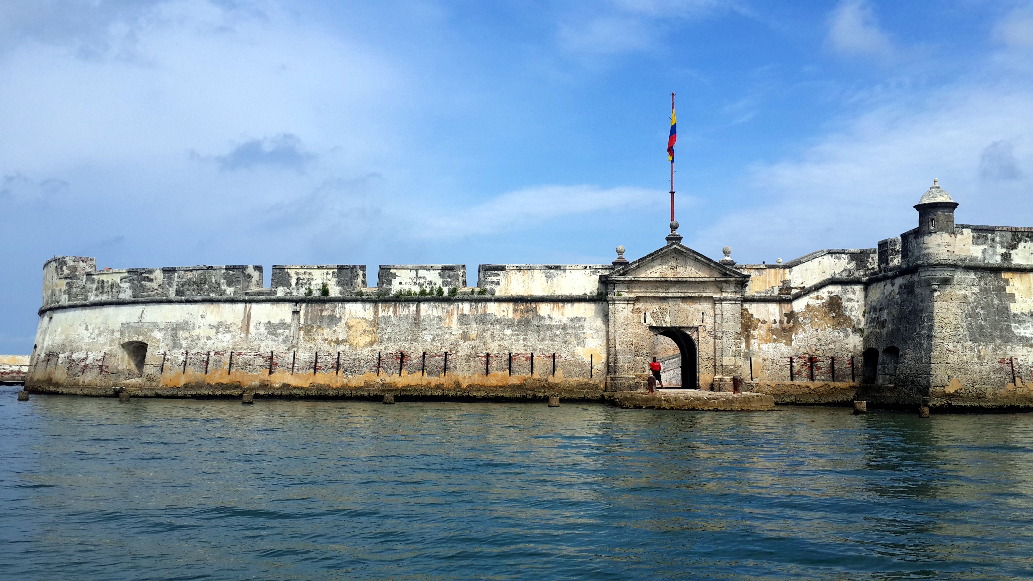
San Fernando Rises from the Ashes
Spain did not abandon the site. In 1753, the military engineer Antonio de Arevalo began constructing a replacement fortress directly over the ruins of San Luis. The new Castle of San Fernando de Bocachica was completed in 1759, a more modern fortification designed with the lessons of 1741 in mind. Arevalo, who would spend decades strengthening Cartagena's defenses, built San Fernando lower and thicker, better able to absorb the kind of sustained bombardment that had crumbled its predecessor. Today the fortress stands as one of Cartagena's most striking tourist attractions, its coral-stone walls rising from the waterline of Tierra Bomba Island. Visitors arrive by boat, passing through the same narrow channel that once funneled Spanish galleons, French raiders, and British warships into the crosshairs of whatever fortress happened to be standing guard.
From the Air
Located at 10.32°N, 75.58°W on the southern tip of Tierra Bomba Island, guarding the Bocachica channel entrance to Cartagena Bay. The fortress is visible from 3,000-5,000 feet as a stone structure at the water's edge on the narrow strait. The channel itself is strikingly narrow when viewed from above. Nearest airport: Rafael Nunez International Airport, Cartagena (SKCG/CTG), approximately 8 nm northeast. Look for the contrast between the open Caribbean to the south and the enclosed bay to the north, with the fortress marking the transition point.