Catalina Airport
The runway at Catalina Airport ends at the edge of a cliff. Approach from the wrong direction in strong southwest winds and a downdraft can push your aircraft toward the ground. Land too fast and you might roll off the far end before you realize the pavement continues beyond what you can see. This is the Airport in the Sky, perched near the highest point of Santa Catalina Island, where pilots have been testing their skills since the 1940s. Many aircraft rental agencies refuse to let customers fly here without completing a special Catalina checkout first.
Buffalo Springs
The airfield began as Buffalo Springs Airport, a name drawn from the island's interior springs. In autumn 1942, the United States Army Air Forces took control of the facility to support military activities on the island during World War II. The Army, Navy, Coast Guard, Maritime Service, and Office of Strategic Services all used Catalina during the war, and the airfield operated as a sub-base of March Field in Riverside County. A USAAF Fourth Air Force Replacement Training Station occupied the site. When the war ended, the military departed, and California aviation veteran Richard Probert, who lived from 1907 to 2008, worked to open the airport to civilian use. He built the terminal building that welcomed peacetime visitors.
The Airline Era
Commercial aviation came to Catalina in the early 1950s, when United Airlines began scheduled service with Douglas DC-3 aircraft flying nonstop to Long Beach and connecting to Los Angeles International. Catalina Air Lines followed with de Havilland Doves serving LAX and Burbank. Pacific Air Lines, Golden West Airlines, Trans Catalina Airlines, and Catalina-Vegas Airlines all operated routes at various times. By 1979, Trans Catalina was running hourly shuttle service from Orange County and Long Beach, with eleven daily flights departing every hour from 8 AM to 6 PM. The island had become a quick hop from the mainland for day-trippers and weekend visitors. Resort Commuter Airlines, operating as Trans World Express for TWA, continued service into 1987.
The Tabletop Challenge
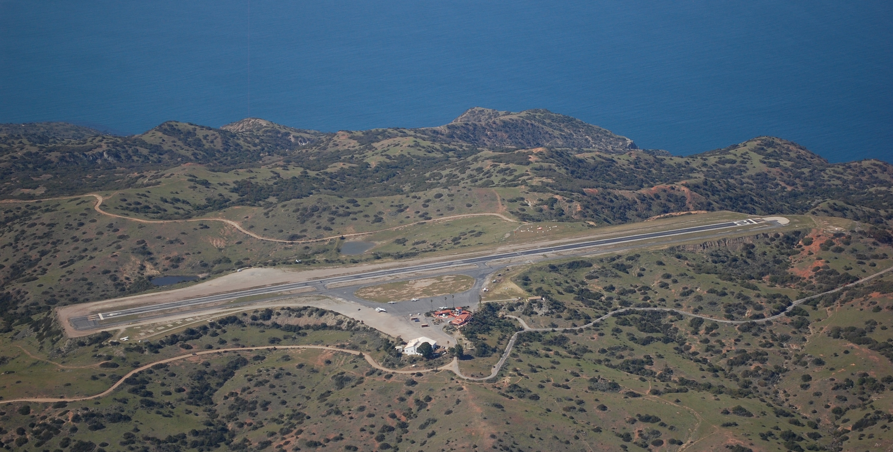
Runway 4/22 is what pilots call a tabletop runway, built on a flattened hilltop with terrain dropping away on all sides. The asphalt extends nearly to the edges of the plateau, with the far end becoming visible only as an aircraft approaches the crest. Pilots unfamiliar with the airport have blown tires or suffered accidents thinking they were about to run off the end when more pavement lay just ahead. In January 1984, a private Learjet overshot Runway 22, killing six people. The accident prompted the Catalina Island Conservancy to restrict the types of aircraft permitted to land. Pilot caution remains essential, and the airport closes at dusk, having no runway lights.
Marines on the Mountain
By the 2010s, seventy years of use had left the asphalt runway crumbling, requiring hundreds of thousands of dollars in annual maintenance. The Aeronautics Division of Caltrans directed the Catalina Island Conservancy to develop a long-term repair plan. The solution came from an unexpected source: the United States Marine Corps at Camp Pendleton. In January 2019, 120 Marines invaded Catalina Island for a training exercise that involved rebuilding the runway. They erected an encampment at the airport and spent months resurfacing the strip. The work cost approximately five million dollars, paid by the airport owners. On May 3, 2019, the runway reopened. The first aircraft to touch down was a 1944 Douglas DC-3 that had originally been owned by the Wrigley family.
Island Gateway
Today the Catalina Island Conservancy owns and operates the airport, permitting air charter and general aviation access. Daily airfreight deliveries keep the island supplied with goods from the mainland. Film crews have used the location, including the 1979 comedy The In-Laws, where the tower stood in for a rural Latin American airport. The restaurant at Buffalo Springs Station serves visitors who fly in for lunch. At 1,602 feet above sea level, surrounded by the island's rugged interior terrain, Catalina Airport remains one of California's most distinctive aviation destinations, a place where the rewards of reaching the runway match the challenges of getting there.
From the Air
Catalina Airport (KAVX) sits at 1,602 feet MSL at coordinates 33.405N, 118.416W, approximately 10 nautical miles from Avalon. Runway 4/22 is a 3,000-foot tabletop strip requiring careful planning. Approach Runway 22 with caution in southwest winds due to potential downdrafts. The runway extends beyond the visible crest, deceiving pilots unfamiliar with the layout. The airport closes at sunset due to no lighting. Contact the Catalina Island Conservancy for current operating requirements. Nearest mainland alternatives are Long Beach (KLGB), John Wayne (KSNA), and Los Angeles International (KLAX).