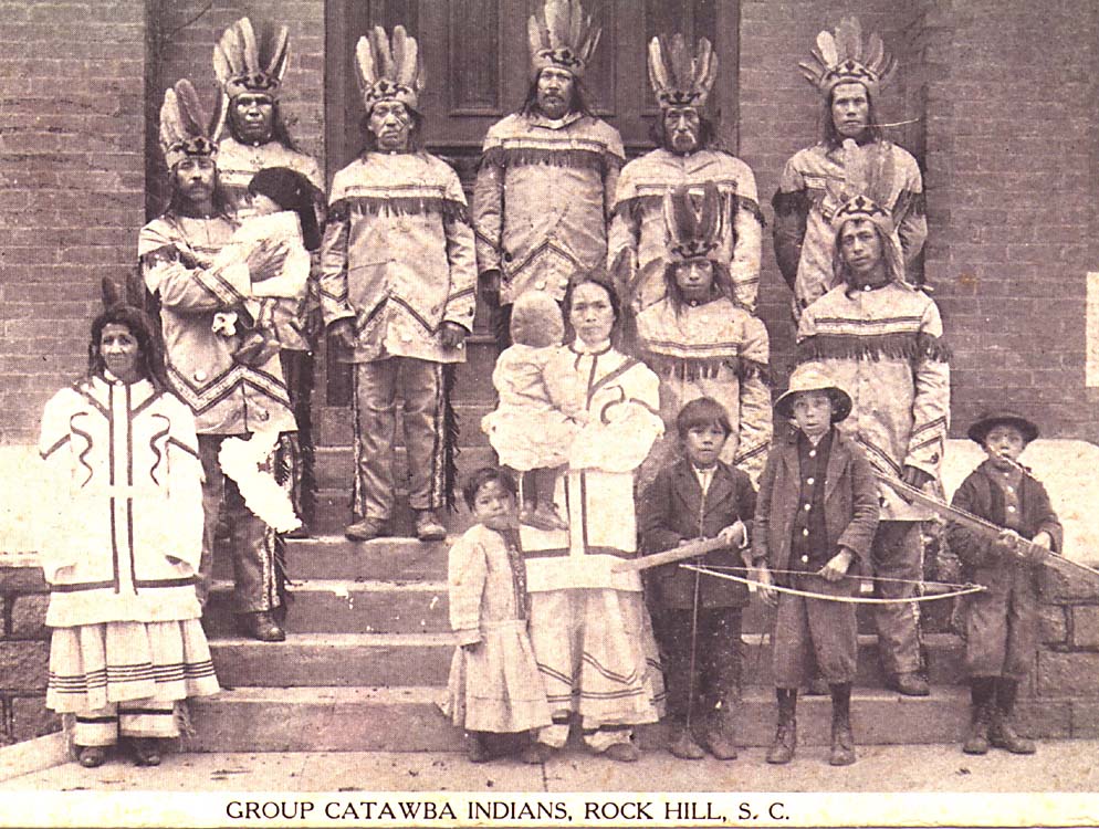
Catawba People
Their name means river. The Catawba - or Iswa in their own Siouan language - defined themselves by the waterway that threads through the Carolina Piedmont, the same river that still bears their name from its headwaters in North Carolina through South Carolina, where it becomes the Wateree. For centuries the Catawba were among the most powerful tribes in the Southeast, their territory stretching across what is now both Carolinas. The Iroquois called them Totiri. European colonists called them allies. The federal government, in 1959, called them terminated. But the Catawba refused every attempt to erase them, and today their nation - headquartered at Rock Hill, South Carolina - stands as one of the most remarkable stories of Indigenous survival on the East Coast.
Warriors of the Piedmont
The Catawba occupied their territory along the river corridor from at least the Paleoindian period, around 10,000 B.C. By the time Europeans arrived, they were the dominant force in the Carolina Piedmont, absorbing smaller tribes whose numbers were collapsing from the catastrophic effects of colonization. The Catawba were fierce fighters. They battled the Haudenosaunee Seneca nation and the Algonquian-speaking Lenape for hunting territory, chasing raiding parties hundreds of miles north across the Potomac River in the 1720s and 1730s. One pursuit ended in a pitched battle near Leesburg, Virginia. Other clashes were recorded at Franklin, West Virginia, at Hanging Rocks, and near the mouths of Antietam Creek and Conococheague Creek in Maryland. During the American Revolution, the Catawba sided with the colonists against the British, withdrawing temporarily into Virginia in 1780 when British troops approached their reservation.
The Long Dispossession
The colonial government of South Carolina confirmed a Catawba reservation in 1763, on both sides of the Catawba River within present-day York and Lancaster counties. It was the beginning of a two-century erosion. By 1826, dwindling numbers - as few as 110 people by one 1896 estimate - forced the Catawba to lease half their reservation to white settlers for a meager annuity. In 1840, the Treaty of Nation Ford stripped them of nearly all remaining land. That treaty was illegal from the start: South Carolina had no authority to negotiate it, federal approval was never granted, and Senate ratification never came. Some Catawba, exhausted by conditions among the settlers, left to join the Cherokee in western North Carolina. Finding life among former enemies no more pleasant, most returned. An elderly Catawba woman, the last of those who had gone west, died among the Cherokee in 1889.
Terminated and Reborn
Federal recognition came in 1941, and the Catawba adopted a written constitution in 1944 - the same year South Carolina granted them citizenship but denied them the right to vote. Native Americans in the state could not cast ballots until the late 1960s, after the Voting Rights Act of 1965. Then, in 1959, the federal government terminated the Catawba under its assimilation policy, cutting off benefits and dividing communal land among individual households. The Catawba responded by reorganizing. In 1973 they established tribal enrollment and began the decades-long process of regaining federal recognition. They adopted a new constitution in 1975. The fight culminated in 1993 when Congress passed the Catawba Indian Tribe of South Carolina Land Claims Settlement Act, reversing termination, recognizing the nation, and awarding $50 million to settle claims rooted in that illegal 1840 treaty.
Clay and Memory
The Catawba are believed to possess the oldest surviving pottery tradition east of the Mississippi River, and possibly one of the oldest on the American continent. Catawba women have been making pottery and baskets for centuries, arts they continue to practice and teach at the Catawba Cultural Center near Rock Hill. The annual Yap Ye Iswa celebration - roughly translated as Day of the People, or Day of the River People - draws the community together each year to honor their heritage. The Catawba language, a Siouan tongue from the Catawban branch, had nearly vanished but is now being actively revived. As of the most recent counts, the Catawba Nation has grown to approximately 2,600 citizens, most living in South Carolina. They remain, as they have been for twelve thousand years, the people of the river.
From the Air
Located at 34.90°N, 80.88°W near Rock Hill, South Carolina, along the Catawba River in the Carolina Piedmont. The Catawba reservation and tribal headquarters are just south of the North Carolina border. From the air, the Catawba River is the defining geographic feature - winding through rolling Piedmont terrain from the Blue Ridge foothills to the coastal plain. Nearest major airport is Charlotte Douglas International Airport (KCLT), approximately 25 nm northwest. Rock Hill/York County Airport (KUZA) is closer at roughly 5 nm. The landscape is gently rolling farmland and suburban development, distinctly different from the mountain terrain to the west. Best viewed from 3,000-5,000 ft AGL.