Caura National Park
At 75,340 square kilometers, Caura National Park is roughly the size of Panama. It is the largest national park in Venezuela and, when it was decreed in March 2017, the newest. Yet for a protected area of such staggering scale, it arrived quietly, the culmination of a half-century of incremental protections that began in 1968. The park encompasses the watershed of the Caura River, a major tributary of the Orinoco that drains some of the most intact tropical rainforest left on the South American continent. From the air, it is an unbroken canopy stretching from the state of Bolivar into Amazonas, interrupted only by the dark ribbon of the river and the occasional white scar of rapids.
Fifty Years in the Making
The protection of the Caura basin did not happen in a single act of political will. In 1968, during the government of Raul Leoni, the Venezuelan state created several forest reserves that included the Caura area, establishing the legal framework for conservation without yet granting full national park status. Four decades later, in 2008, the government of Hugo Chavez launched the Caura Plan, a more focused initiative to protect the river basin's resources from the encroachment of mining and logging. The final step came in March 2017, when the administration of Nicolas Maduro decreed the creation of Caura National Park, consolidating the protected territory between Bolivar and Amazonas states. Its first management plan followed a year later, in March 2018. The park's creation was not without controversy; indigenous communities and some scientists raised concerns about how the designation would affect traditional land use and self-governance in the region.
Canopy Without End
The park sits within the Guianan Highlands moist forests ecoregion, one of the most biodiverse and least disturbed tropical forest systems remaining anywhere. The dominant vegetation is tropical rainforest, dense and layered, with a canopy so continuous that the forest floor receives only scattered light. Among the notable tree species are mahogany, carapa, and the araguaney, Venezuela's national tree, whose yellow blossoms erupt in brilliant displays during the dry season. Cabimo oil trees provide resin that local communities have harvested for generations. The sheer extent of unbroken forest is the park's defining feature. From ground level, the scale is impossible to grasp. From altitude, the green stretches to every horizon, broken only where the Caura and its tributaries have carved their channels.
Jaguars, Tapirs, and the Pressure of Proximity
Caura's fauna catalogue reads like an inventory of South American tropical wildlife at full strength. Tapirs move through the understory on trails worn smooth by generations of use. White-lipped peccaries travel in herds large enough to be heard before they are seen. Giant anteaters, yellow-bellied spider monkeys, and collared peccaries share the forest with large carnivores: jaguars, pumas, and tayras. Overhead, black curassows and crestless curassows forage in the canopy. But this abundance is not guaranteed. Research published in 2016 by the University of Washington and the Wildlife Conservation Society documented that hunting pressure from growing human populations in and around the park was already affecting wildlife numbers. The park's size offers a buffer, but size alone does not confer protection when enforcement is thin and communities depend on bushmeat for protein.
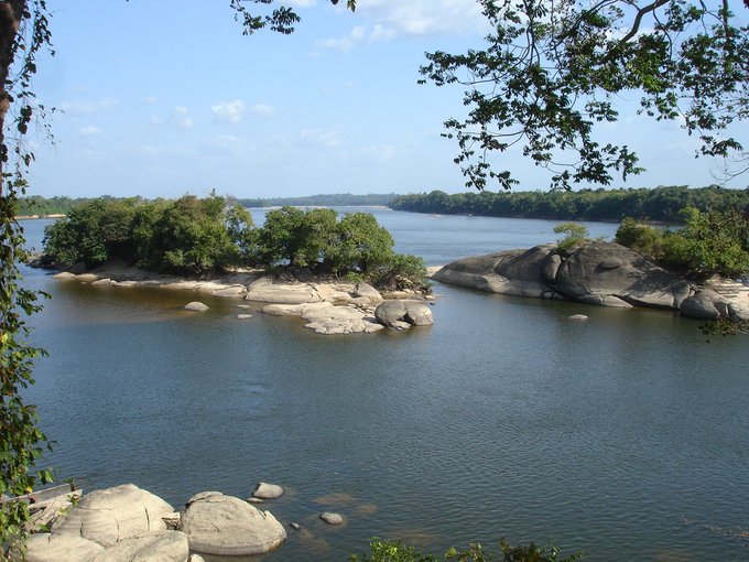
The River at the Heart
The Caura River gives the park both its name and its ecological backbone. Rising in the Guiana Highlands, the Caura flows north to join the Orinoco, its dark waters stained by tannins leached from the forest floor. Along its course, the river drops over Para Falls, one of the most impressive cataracts in the Guiana region, notable less for sheer height than for the enormous volume of water that pours over its lip during the rainy season. The Erebato tributary joins from the left bank, adding its own considerable flow. For indigenous Ye'kwana and Sanema communities who have lived along these waterways for centuries, the river is not scenery but infrastructure: a transportation network, a fishing ground, and a source of the fresh water on which forest life depends. Their relationship with the park's administration remains a point of ongoing negotiation.
From the Air
Centered near 7.64°N, 64.88°W. Caura National Park is an enormous tract of unbroken tropical forest visible from any cruising altitude as a dark green expanse stretching across southeastern Venezuela. The Caura River is traceable as a sinuous dark line running north toward the Orinoco. Para Falls may be visible as a white disruption in the river's course. Nearest airports include SVPR (Puerto Ordaz/Ciudad Guayana) and SVCB (Ciudad Bolivar). The park spans parts of Bolivar and Amazonas states.