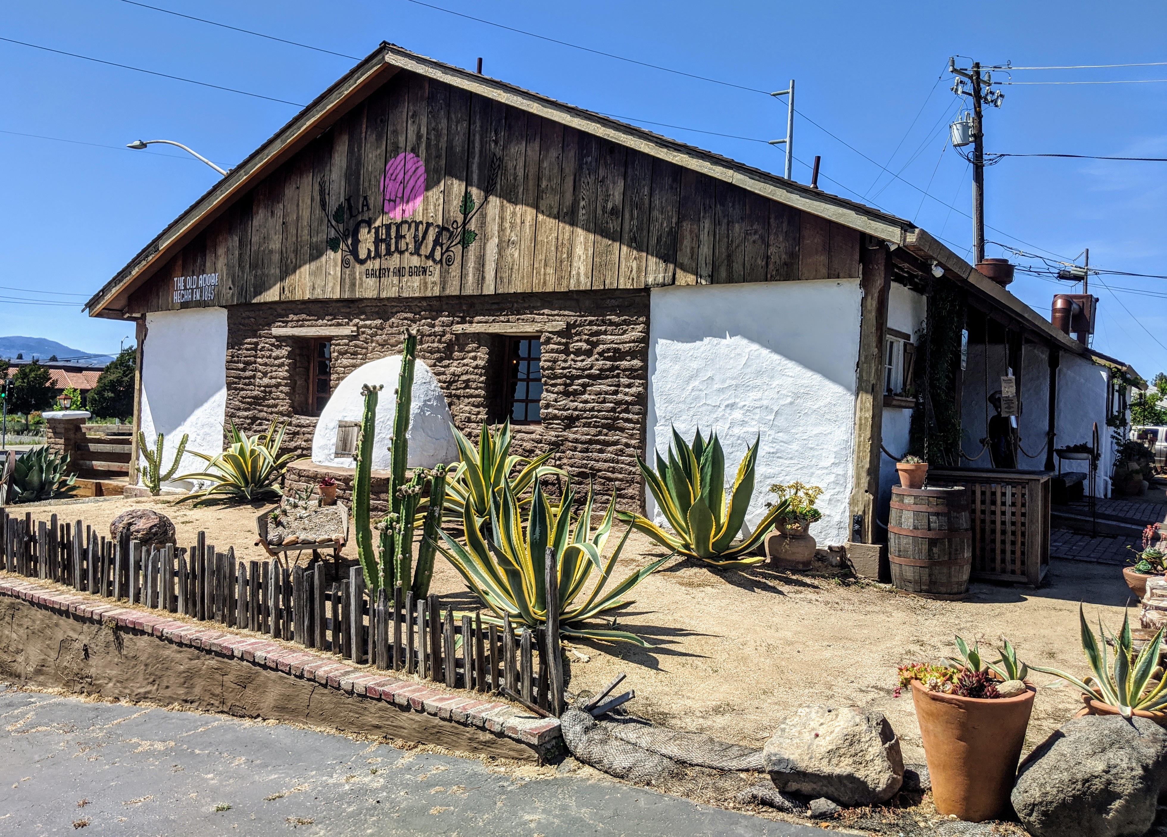
The Old Adobe
The walls are three feet thick at the base. They were made from adobe bricks mixed with horse manure and hay, shaped by hand in 1845 by workers on Cayetano Juarez's rancho, and they are still holding up a building in downtown Napa. The Cayetano Juarez Adobe -- locals just call it the Old Adobe -- is the oldest structure in the city, a relic of the brief window when California was governed from Mexico City and men like Juarez built their lives at the intersection of Mexican authority, Native American community, and a land that was about to be taken from both of them.
A Californio's Kingdom
Cayetano Juarez was born in 1809 and came to the Napa Valley as a soldier in the Mexican Army. By 1840, he had received a land grant called Rancho Tulucay, where he raised cattle and horses on rolling hills that would someday be planted with Cabernet Sauvignon. He built his first adobe home on the rancho that year, but it did not survive. The second, larger adobe house, constructed in 1845, did. Juarez employed about 400 Native American workers on his land, raising cattle and field crops. His children grew up speaking Patwin, the local Native American language, a detail that reveals how intertwined these communities were before the Gold Rush changed everything. His descendants remained active in Napa Valley civic life for five generations.
Built to Last, Barely
The adobe sits less than half a mile east of the Napa River, at the start of the Silverado Trail -- the first permanent road between Napa and Calistoga, established in 1852 to serve the mercury mines on the slopes of Mount Saint Helena. The rectangular building was constructed primarily from adobe brick, with walls tapering from three feet thick at the foundation to two feet above the attic. Old-growth redwood posts, chamfered at eight inches square, support the overhanging porch; three of the four originals survive. Wooden beams and exposed rafters give the interior a skeletal honesty that restoration later revealed beneath layers of ill-advised renovation. Over the decades, the building was converted from a family home to a restaurant and bar, suffering what architect Juliana Inman of the Napa County Landmarks Board described as abuse: "terrible additions," structural neglect, and the slow erasure of its original character.
Bringing It Back with Mud and Manure
In 2014, George Altamura purchased the building, and his son Justin took on the restoration as a personal mission. Justin Altamura studied the preservation of historic adobe structures and made a deliberate choice: traditional materials and techniques wherever possible. Over 300 large adobe bricks were manufactured by hand using the same recipe of clay, horse manure, and hay that Juarez's workers had used 170 years earlier. A team of expert Mexican masons repaired and replaced the traditional mud mortar between the original bricks. Original wooden beams were exposed again. The entrance door was restored to its nineteenth-century appearance. The building was listed on the National Register of Historic Places in 2015, midway through the painstaking work. By early March 2019, the renovation was complete -- though its opening as a restaurant was delayed two months by the COVID-19 pandemic.
Tacos in a Time Capsule
Today the Old Adobe houses La Cheve, a Mexican restaurant that serves food beneath the same exposed rafters and thick adobe walls that sheltered Juarez's family. The choice of tenant feels right: a Mexican restaurant in a building constructed during the Mexican period of California history, on land that once belonged to a Californio rancher. Inman praised the restoration for giving the building "some cachet and some importance" after decades of degradation. Walking through the door, you pass beneath the porch supported by those original redwood posts and enter a space where the walls themselves are artifacts -- three feet of earth and straw separating the present from a time when the Napa Valley was cattle country, the language of the household was Patwin, and California belonged to Mexico.
From the Air
Located at 38.29N, 122.28W in downtown Napa, just east of the Napa River near the start of the Silverado Trail. The small adobe building is not individually visible from altitude, but the Napa River corridor and the grid of downtown Napa provide clear visual reference. Napa County Airport (KAPC) is 5nm south. The Silverado Trail extends northeast from this point toward Calistoga and Mount Saint Helena, which rises to 4,342 feet and is visible from considerable distance. Best viewed at low altitude on approach to KAPC or during a scenic flight up the Napa Valley.