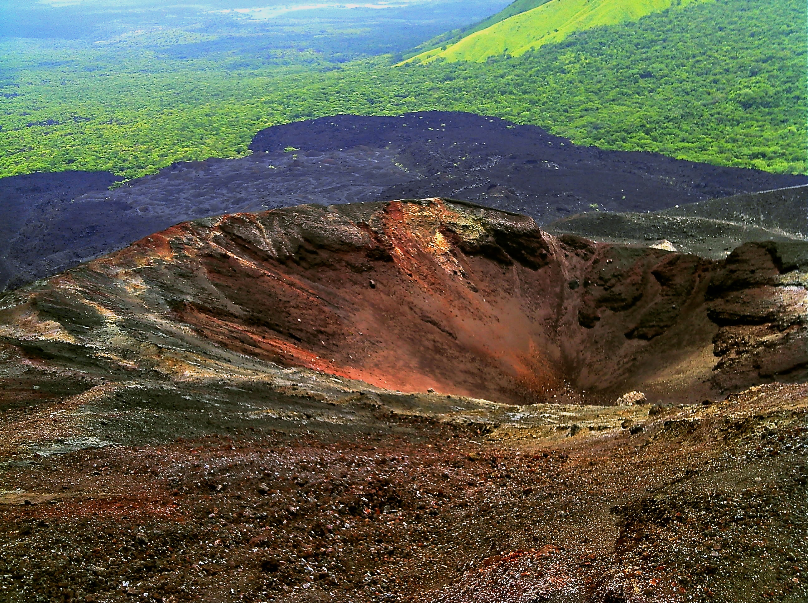
Cerro Negro
Most volcanoes are ancient things, ground down by millennia of weather and memory. Cerro Negro is not. In April 1850, a farmer's field in the Cordillera de los Maribios split open, and basaltic cinder began piling into a cone where none had existed before. The volcano was barely older than the Republic of Nicaragua itself. Its name means "Black Hill," and from the air the reason is obvious: a dark, gravelly pyramid standing in sharp contrast to the green hillsides surrounding it, like a charcoal smudge on an emerald cloth. In the century and a half since that first eruption, Cerro Negro has erupted at least 23 times, making it one of the most restless volcanoes in a country defined by volcanic activity.
Born Yesterday, Geologically Speaking
Cerro Negro sits along a northwest-southeast trend line in the Cordillera de los Maribios, part of the Central American Volcanic Arc created by the Cocos Plate diving beneath the Caribbean Plate at roughly nine centimeters per year. It is the largest and southernmost of four cinder cones that have formed along this alignment, and despite being the youngest volcano in Central America, it has been one of Nicaragua's most active. The first eruption lasted from April 13 to May 27, 1850, producing lava flows and property damage near the village of Malpaisillo, about ten kilometers away. What makes Cerro Negro unusual is not just its youth but its behavior: during several eruptions, ash vents from the summit while lava simultaneously pours from fractures at the base, as if the volcano cannot decide which way to express itself.
A Century of Fire
The eruption record reads like a drumbeat quickening over time. After the 1850 birth, eruptions followed in 1867, 1899, 1914, 1919, and 1923 — the last of which was a notable sub-Plinian event that ejected 36 million cubic meters of tephra. The pace accelerated at mid-century: 1947 brought the largest eruption in the volcano’s history, forcing evacuations of Malpaisillo, and eruptions struck again in 1948, 1950, 1954, 1957, 1960, 1961, 1962, and 1963. The 1968 eruption created the Cristo Rey crater, sent ash raining over Leon — Nicaragua's second-largest city, about 20 kilometers away — and produced incandescent gas plumes visible from 50 kilometers. In 1971, volcanic bombs shot 600 meters into the air, and Leon recorded 18 centimeters of ash, collapsing buildings across the city.
When the Ash Reached Leon
The 1992 eruption, after two decades of quiet, reminded everyone what Cerro Negro could do. Over five days beginning April 9, a sub-Plinian column rose seven kilometers into the sky. More than 20,000 people were evacuated as water systems failed under the ashfall. Four centimeters of tephra blanketed Leon, caving in roofs and causing fatalities. Three years later, the 1995 eruption arrived in two phases: 79 days of phreatic explosions averaging 100 to 160 blasts per day, followed by a pause, then 13 days of larger eruptions that ejected two-meter boulders from the crater. New lava filled two-thirds of the 1992 crater and added roughly 50 meters of height to the cone. Six thousand people evacuated safely. The final eruption, in August 1999, was triggered by three magnitude-5.2 earthquakes in three hours — the first time large-magnitude quakes had preceded an eruption at Cerro Negro.
Boarding the Black Hill
Today, Cerro Negro has become one of Nicaragua's most unlikely tourist attractions. Visitors hike up the loose, gravelly slopes of the cinder cone, then ride back down on wooden boards at speeds that can exceed 50 kilometers per hour — an activity that has been dubbed "volcano boarding." The contrast is striking: a volcano that has buried cities in ash, forced tens of thousands from their homes, and killed people in living memory now draws backpackers seeking an adrenaline rush on its flanks. Meanwhile, the Nicaraguan Seismic Network and INETER maintain monitoring stations on the volcano, tracking seismic activity, gas concentrations, surface deformation, and temperature shifts. Cerro Negro's CO2 output is estimated at 2,800 tonnes per day. Volcanologists have developed a time-volume prediction model correlating the timing of future eruptions with the volume of previous ones, and another large-scale eruption is considered overdue.
A Living Laboratory
Because Cerro Negro has been erupting since 1850, scientists have been able to document the entire growth of a volcano in real time — something rarely possible. Every eruption has been recorded, measured, and analyzed, creating a dataset that spans the volcano's complete lifespan. The biggest hazard is not lava or pyroclastic flows, which tend to stay away from major population centers, but the vast quantities of ash and tephra that can blanket hundreds of square kilometers. From above, the volcano looks deceptively small against the green mountain range, but the dark cone tells its own story: here is a piece of the Earth that did not exist two centuries ago, that has grown taller with nearly every eruption, and that is almost certainly not finished.
From the Air
Cerro Negro sits at 12.508°N, 86.703°W in the Cordillera de los Maribios, northwest Nicaragua. From 5,000–8,000 feet AGL, the dark cinder cone is starkly visible against the surrounding green hillsides. The city of Leon (MNLN) lies approximately 20 km to the southeast. Augusto C. Sandino International Airport (MNMG) in Managua is about 120 km to the southeast. Be aware of volcanic gas emissions and potential ash hazards; check NOTAMs for volcanic activity advisories.